2. 中国科学院青藏高原研究所, 北京 100101;
3. 中国科学院青藏高原地球科学卓越创新中心, 北京 100101;
4. 南京信息工程大学大气科学学院, 江苏 南京 210000
青藏高原(下称高原)是全球面积最大、平均海拔最高的高原之一, 有世界“第三极”之称。由于高原的高海拔和特殊地形, 其独特的热力强迫作用对中低纬度地区的天气、气候的形成及变化具有重要的影响(Yanai et al, 1992; Duan et al, 2005; Ma et al, 2015, 2017)。自叶笃正(1974)发现夏季高原作为热源对环流结构产生重要的作用起, 大量研究人员对高原研究做出了相关贡献(Sun et al, 2017; Huang et al, 2017; Ma et al, 2014, 2011, 2006; Hu et al, 2004)。通过分析大气的热力适应、局地尺度加热和大陆尺度加热的综合效应, 吴国雄等(2005)提出了高原夏季地表加热对增强东亚季风和中亚干旱的作用。
近年来全球范围内气候经历着巨大变化, 尤以山区最为显著(Diaz et al, 1997)。高原是气候变化的敏感区域, 其气候变化特征及其对中国乃至全球气候的影响受到研究人员广泛关注, 并主要集中在降水、温度、积雪、风速等气候要素以及气溶胶、臭氧等大气成分方面(Rangwala et al, 2010; Wu et al, 2010; Lau et al, 2006; Chen et al, 2013)。气候变化背景下, 作为影响大气热力效应中最主要的因素之一, 高原地表加热特征也存在较显著的变化。植被和积雪作为高原地区两种最为重要的陆面覆盖类型与同期的地表加热存在密切的联系(于琳琳等, 2012)。湍流感热作为高原地气系统进行热量交换的主要形式之一, 受南亚季风增强的影响呈现显著减弱的趋势(Wu et al, 2003)。此外, 利用气象观测数据, Duan et al(2008, 2009)发现地表风速的降低是影响高原近30年来感热通量变化的最主要因素。Shi et al(2014)根据台站观测、再分析资料以及卫星数据发现, 高原潜热通量在各季节呈逐渐增加的趋势。夏季南亚季风的加强会改变高原降水从而改变水蒸汽冷凝所释放的潜热以及地面接收的向下长波辐射(Avissar et al, 1998)。
已有研究往往将潜热及感热单独考虑或者将二者视为整体研究(李栋梁等, 2007), 并重点集中在分析高原地面加热场的时空分布特征、变化趋势、影响因素及其气候效应(Ma et al, 2009)。但潜热通量和感热通量作为两个相互独立且相互联系的气候要素, 二者变化趋势间的联系不容忽视。因此本文将重点对潜热和感热之间的联系进行探讨, 同时对地面加热场的时空分布特征及其年际变化趋势进行分析, 并在此基础上研究高原春季感热及潜热变化的可能影响机制。
2 资料选取受地形因素的限制, 高原地区气象台站分布不均, 因而台站数据不能全面和准确地代表高原地表热状况的空间特征及其在气候变暖背景下的变化趋势。ERA-Interim再分析资料由于其格点数据的特征弥补了这一局限。ERA-Interim由欧洲中期天气预报中心(ECMWF)发布, 提供了自1979年以来的再分析资料, 并实时更新。相比于ERA-40数据同化模型, ERA-Interim采用了四维变分分析, 并结合改进的湿度分析、卫星数据误差校正等技术, 实现了再分析资料的质量提升(Simmons et al, 2007)。选用1979年3月至2009年2月分辨率为0.5°×0.5°的ERA-Interim逐日地表热通量再分析资料(包含感热通量及潜热通量数据)来分析30年高原地区地面加热场的时空分布特征及其年际变化趋势。研究表明, 通过对再分析资料地表热通量数据的评估, ERA-Interim可基本重现高原地表感热通量的年际变化趋势, 具有一定的准确性和可靠性(刘超等, 2015; 张浩鑫等, 2017)。ERA-Interim地表热通量数据被广泛应用到高原地表加热场与我国东部降水以及海温变化等的联系的研究中(于琳琳等, 2012; 金蕊等, 2016)。
采用的其他再分析资料有: ERA-Interim月平均位势高度、经向风速、纬向风速、垂直风速以及GPCC月平均降水数据, 资料的水平分辨率为2.5°×2.5°。GPCC(Global Precipitation Climatology Project)降水资料是全球降水气候计划利用全球6 000多个测站的常观测资料和少量的卫星资料, 通过卫星反演降水与地面站点观测降水合并计算集成的月降水量资料(Schneider et al, 2005)。
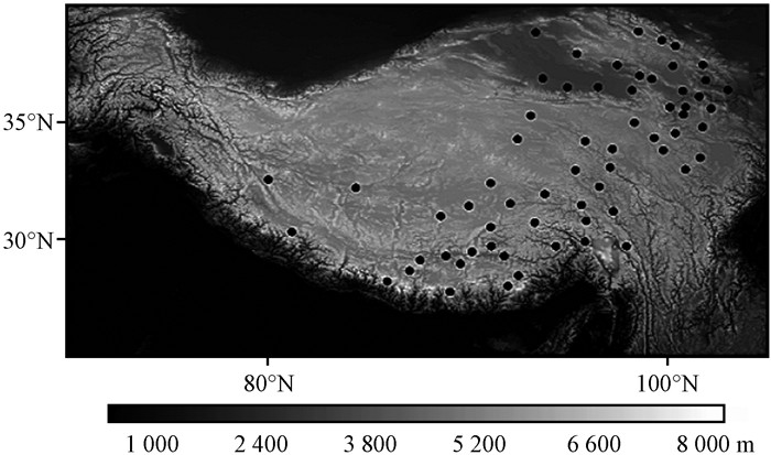
选用国家气象信息中心提供的高原地区个57个站点1979—2008年春季逐日降水、地表风速、气温和0 cm地温资料, 研究范围包括我国青海省以及西藏省, 站点分布如图 1所示。
|
图 1 青藏高原地形(阴影区, 单位: m)及站点(黑点)分布 Figure 1 Locations of surface observation stations (black dots) and spatial distribution of the topography (the shaded, unit: m) over Qinghai-Tibetan Plateau (QTP) |
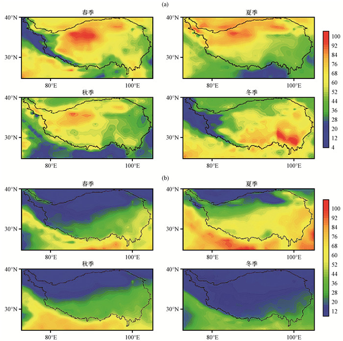
通过1979年3月至2009年2月高原四季感热通量空间分布[图 2(a)]可以看出, 高原感热全年季均值都为正值, 其中春季在高原西北部出现了高于100 W·m-2的峰值。随着太阳辐射的增强, 青藏高原春、夏两季感热通量远高于秋、冬两季的感热通量, 由此可见, 地表感热是高原热力状况的最重要组成部分。除冬季外, 高原感热空间分布呈现为自西北向东南递减的特征, 冬季感热通量最大值出现在高原东南部而其他三季则在高原西南部出现感热通量最大值。以下是对该现象的可能解释:高原西北部受高海拔以及复杂地形的影响, 相比于高原东南部, 降水量较少和植被也较为稀疏, 从而导致了更强的地表风速以及更大的地气温差, 使得高原西北部感热通量在春、夏、秋季高于东南部的现象形成; 而在冬季, 由于太阳辐射处于全年最低阶段, 日间地气温差差异不明显的情况下, 加之高原西北部植被较稀疏, 导致夜间地气温差出现更大负值(Yang et al, 2011), 从而使得冬季高原西北部感热通量低于东南部。
|
图 2 1979年3月至2009年2月青藏高原感热通量(a)及潜热通量(b)在不同季节的空间分布(单位: W·m-2) Figure 2 Spatial distributions of sensible heating (a) and latent heating (b) over the QTP from March 1979 to February 2009 in different seasons.Unit: W·m-2 |
从1979年3月至2009年2月高原潜热通量在不同季节的空间分布特征[图 2(b)]可以看出, 高原四季潜热都为正值, 且受南亚夏季风爆发的影响, 在夏季达到最高值, 冬季则为潜热最弱的季节。从空间分布来看, 高原四季感热空间分布呈现自东南向西北递减的特征, 基本与感热通量呈反相分布。从图 2(b)中可以看出, 高原西南部地区潜热在各季节都相对较强, 这可能与冷季印缅槽的维持, 暖季南亚夏季风的建立以及喜马拉雅山脉高海拔导致的常年积雪有关。
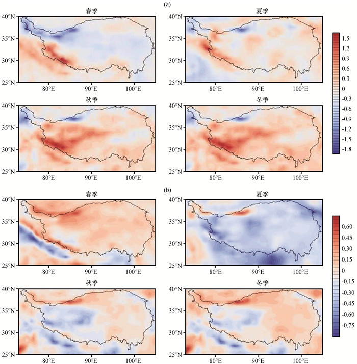
3.2 年际变化趋势为研究高原地面热状况的年际变化趋势, 利用最小二乘法计算了高原各季节地表热通量线性变化趋势的空间分布(图 3), 高原四季感热通量线性变化趋势空间分布[图 3(a)]显示, 春、秋、冬三季高原大部分地区感热通量年际变率分别为负、正、正, 而夏季则没有明显空间变化特征。不难发现, 高原西南及西北部各季节感热通量都呈现出相反的年际变化, 大体上表现为西南部增强而西北部减弱的趋势。高原东部感热通量变化趋势空间模态则相对一致。值得注意的是, 春季高原潜热通量[图 3(b)]显著增加而夏季潜热则呈显著减弱的趋势。对于秋季和冬季而言, 高原东部潜热增强, 西部潜热减弱。由于各季节高原地表热通量年变化趋势空间分布在东部相对一致, 为更好的研究高原地面加热场与气候要素间的联系, 选择90°E—100°E, 28°N—38°N作为研究区域对高原感热和潜热年际变化进行进一步分析。
|
图 3 1979年3月至2009年2月青藏高原感热通量(a)及潜热通量(b)年变率在不同季节的空间分布[单位: W·m-2·(10a)-1] Figure 3 Spatial distributions of the change rate of sensible heating (a) and latent heating (b) over the QTP from March 1979 to February 2009 in different seasons.Unit: W·m-2·(10a)-1 |
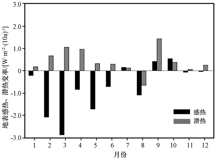
从1979年3月至2009年2月高原感热和潜热各月的变化率(图 4)中可以看出, 感热在大部分月份出现减弱趋势, 其中3月减弱较明显, 为-2.88 W·m-2·(10a)-1, 感热通量年变率为正的月份有7月、9月及10月。潜热通量年变率情况大体上与感热相反, 各月潜热主要呈增强趋势, 其中3月、4月和9月增强趋势明显, 增率分别为1.061, 0.976和1.441 W·m-2·(10a)-1。高原四季感热和潜热变率如表 1所示, 春、夏、秋、冬四季感热通量变率分别为-1.83, -0.55, 0.09和-0.08 W·m-2·(10a)-1, 而潜热通量变率分别为0.79, -0.08, 0.63和0.14 W·m-2·(10a)-1。由此可见, 高原感热和潜热通量变化趋势在春季较为显著, 其他三个季节则如冬季感热和潜热的变化都非常微弱。通过分析感热和潜热的年际变化发现, 春冬两季感热通量与潜热通量之间存在明显的负相关, 相关系数分别达-0.69和-0.66, 且都通过了95%的显著性检验。其他两个季节潜热通量和感热通量则并无明显的联系。表明可能存在某一气候因子同时影响着春冬两季的潜热和感热通量。由于高原冬季地表热通量数值较小, 对我国东部气候影响有限, 且年际变化并不显著, 本文将选择1979—2008年30年春季地表热通量作为研究对象, 探讨影响高原地面热状况的气候因素, 以期揭示气候变化和高原地面加热场之间的联系。
|
图 4 青藏高原各月潜热、感热变率 Figure 4 The change rate of SH and LH in the QTP for each month |
| 表 1 青藏高原四季地表感热、潜热变率及相关系数 Table 1 The change rate and correlation coefficient of SH and LH in the QTP for four seasons |
根据总体动力学公式, 感热通量可表示为:
| $ SH = {C_P}\rho {C_{{\rm{DH}}}}{V_0}\left({{T_s} - {T_a}} \right)~~~, $ | (1) |
式中: Cp、ρ、CDH分别指在常压下干空气的比热、空气密度以及热量拖曳系数, 由于对高原感热变化影响较小, 在以往的研究中大多被视作常数(Li et al, 1996); V0、Ts-Ta分别代表地表风速和地气温差, 是影响地表高热变化的重要因素。选用高原57个站点地表风速、地温和气温的观测数据以及再分析资料, 研究了高原地表感热通量对地气温差和地表风速的响应。
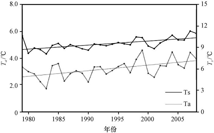
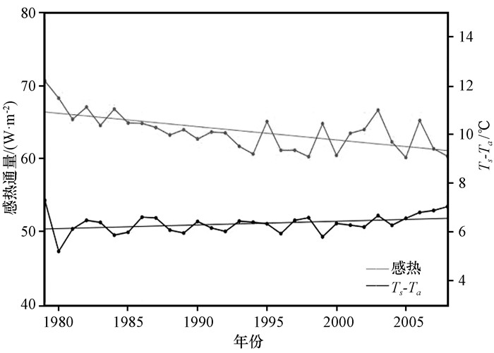
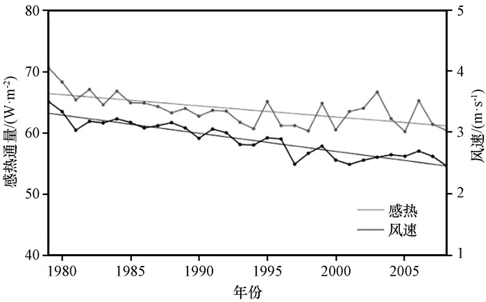
通过高原春季地温和气温的长期变化趋势(图 5)可以看出, 高原春季地温明显高于气温, 多年平均值分别为9.55和3.22 ℃, 说明高原春季感热为正。从1979—2008年高原地温和气温都存在着显著的增加趋势, 年变率分别为0.42和0.57 ℃·m-2·(10a)-1, Liu et al(2000)的研究也发现高原气候变暖显著高于我国其他地区。Rangwala et al(2009)探讨了高原年间的气候变化并推测高原地表湿度变化是高原变暖的主要因素。分析高原地气温差和感热的联系发现(图 6), 高原地气温差呈上升的趋势而地表感热却显著减弱, 且两者之间并没有显著的相关关系。由此可以发现地气温差并不是影响高原地表感热变化的主要原因, 故而可以推断地表风速可能是导致高原感热持续减弱的重要要因素。高原春季感热变化与同期亚欧大陆地表风速相关系数的空间分布情况如图 7所示, 其中降水数据为ERA-Interim提供的再分析资料。进一步分析高原感热与高原地表风速的联系发现(图 7), 高原春季感热与地表风速的年际变化趋势一致, 大体可以分为两个变化阶段, 第一阶段为1979—1994年, 高原地表感热与地表风速都呈显著的持续性减弱趋势, 第二阶段为1995—2008年, 高原地表感热与地表风速呈一致的波动式减弱特征。由上述分析可以发现二者相关性明显, 相关系数为0.70, 显著性水平高于95%。由此可以确定高原感热减弱主要是由于受到地表风速变化的影响。
|
图 5 1979—2008年青藏高原春季地温Ts和气温Ta的年际变化 Figure 5 Interannual variation of spring Ts and Ta in the QTP from 1979 to 2008 |
|
图 6 1979—2008年青藏高原春季感热通量、地气温差Ts-Ta的年际变化 Figure 6 Interannual variation of spring sensible heating, Ts-Ta in the QTP from 1979 to 2008 |
|
图 7 1979—2008年青藏高原春季感热通量和地表风速年际变化 Figure 7 Interannual variation of spring sensible heating and surface wind speed in the QTP from 1979 to 2008 |
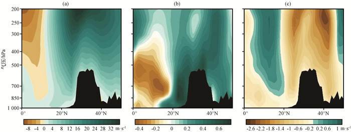
高原是处于副热带西风带控制下的区域[图 8(a)], 高空西风带强度变化可通过动量下传改变高空地表风速(王美蓉等, 2012), 故西风急流的强弱变化可能通过影响高原地表风速从而引起春季感热通量的变化。为确定西风急流与高原地表风速的联系, 从高原地表风速与90°E—100°E平均纬向风速空间相关图[图 8(b)]中发现, 高原地表风速与高原上空西风急流强度存在明显的正相关, 尤其在500 hPa高度附近, 相关系数达到近0.7。值得注意的是, 正相关最大的高值区在高原南侧20°N—25°N的区域, 且20°N以南存在一个明显的负相关区域, 该区域西风强度较弱, 是副热带西风带和热带东风带的过渡区域。
|
图 8 90°E—100°E平均纬向风(a, 单位: m·s-1)、高原地表风速与90°E—100°E平均纬向风速相关分布(b)及感热低年与感热高年90°E—100°E平均纬向风速差值(c, 单位: m·s-1)剖面 黑色阴影区为青藏高原地形 Figure 8 Cross sections of mean zonal wind speed averaged 90°E—100°E (a, unit: m·s-1), correlation coefficient between surface wind speed of the QTP and mean zonal wind speed (b) and difference of mean zonal wind speed between SH-Low years and SH-High years (c, unit: m·s-1).The black shaded represents the topography of QTP |
为研究西风急流对高原感热通量的影响, 分别对高原感热偏强年和偏弱年的同期90°E—100°E平均纬向风速进行了差值分析[图 8(c)]。考虑到潜热与感热的显著负相关, 选取潜热通量低于气候平均且感热通量高于气候平均值的年份作为感热偏强年(潜热偏弱年), 选取潜热通量高于气候平均且感热通量低于气候平均值的年份作为感热偏弱年(潜热偏强年)(表 2)。从图 8(c)中可以发现高原感热强弱年上空西风带强弱有明显差异:感热通量低值年高原及高原北侧西风都有明显的偏弱异常。上述分析说明高原感热通量受地表风速的直接影响, 而导致地表风速变化的直接因素则是高原上空西风急流系统的减弱。
| 表 2 1979年3月至2009年2月感热高年(潜热低年)和感热低年(潜热高年)年份 Table 2 Composites years with high (low) and low (high) SH (LH) from March 1979 to February 2009 |
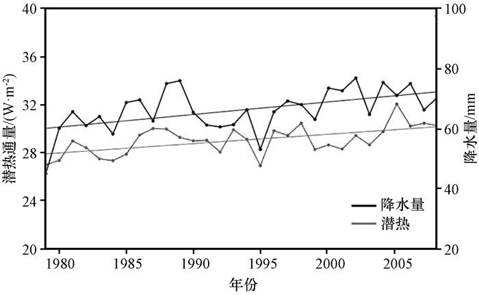
潜热是地面加热场的重要组成, 由地表水汽蒸发并在近地面凝结所释放的能量多少决定, 因而与降水量之间可能存在密切的联系。为了进一步研究高原潜热和降水之间的联系, 利用高原地区57个台站气象观测月降水量数据计算了30年高原春季降水量的变化并与高原潜热变化趋势进行对比分析(图 9)发现, 高原春季降水趋势和潜热变化一致, 整体都表现出增长趋势, 且两者相关性明显, 相关系数达到0.60, 并达到了95%的显著性水平。由此可以确定, 高原春季降水量的增加是引起高原潜热变化的重要因素。
|
图 9 1979—2008年青藏高原春季潜热通量、降水年际变化 Figure 9 Interannual variation of spring LH, precipitation in the QTP from 1979 to 2008 |
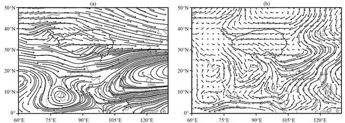
水汽含量是影响降水的重要因素, 通过高原春季多年平均水汽输送空间分布特征[图 11(a)]中可以看出, 春季高原水汽输送主要有两条通道:受到地形因素的影响, 西风携带的水汽在伊朗高原上空分裂成南北两支, 其中北支跨过天山山脉, 通过塔里木盆地或直接到达高原北部; 南支则向南传输与阿拉伯海携带的水汽汇合后通过印度半岛及孟加拉湾携带该地区的水汽最后到达高原上空, 与前者相比, 由于孟加拉湾水汽供给, 南支水汽输送强度相对较强。南北两支传输路径在高原东南部形成较弱的水汽辐合区后在高原东侧输出。为确定西风急流对高原水汽输送的影响, 通过春季亚太地区500 hPa风场30年平均气候特征[图 10(a)]可以发现, 北半球在20°N以北的副热带地区高空存在一稳定、连续的西风带。和水汽输送路径类似, 受高原的大地形作用的影响, 该西风带在高原东部分裂成南北两支, 并在高原北侧形成高压脊, 南侧形成低压槽, 即“印缅槽”(Li et al, 2016)。通过上述分析, 不难发现, 高原在西风带的控制下, 西风急流携带的水汽成为高原春季重要的水汽来源; 孟加拉湾由于地处高原南部, 受印度洋丰富水汽及印缅槽的影响, 对高原水汽输送具有非常重要的意义。

|
图 10 高原春季500 hPa风场多年平均(a, 单位: m·s-1)及其潜热高年与潜热低年差值(b, 单位: m·s-1)空间分布 Figure 10 Springtime spatial distribution of 500 hPa wind field (a, unit: m·s-1) around the QTP from 1979 to 2008 and difference of 500 hPa wind field (b, unit: m·s-1) between LH-High years and LH-Low years |
|
图 11 高原春季整层水汽通量多年平均(a, 单位: kg·m-1·s-1)及其潜热高年与潜热低年差值(b, 单位: kg·m-1·s-1)空间分布 Figure 11 Springtime spatial distribution of water vapor flux (a, unit: kg·m-1·s-1) around the QTP from 1979 to 2008 and difference of water vapor flux (b, unit: kg·m-1·s-1) between LH-High years and LH-Low years |
对潜热通量高年和低年的水汽通量场进行合成分析[图 11(b)]可以看到, 潜热通量高值年高原南部降水量增强, 主要由于孟加拉湾向西北的水汽输送正异常引起的。通过分析潜热通量高值年和低值年春季500 hPa风场差值[图 10(b)]结合纬向风速差值[见图 8(c)]发现, 潜热偏强年, 孟加拉湾上空形成一异常气旋, 在高原南侧西风急流减弱的情况下, 该异常气旋偏北气流转向为西北气流并携带部分水汽到达高原, 部分随高原南侧的异常偏东风到达印度半岛。此外, 由于高原海拔的影响, 该异常气旋所携带的水汽不能到达西南侧, 同时由于西风携带的水汽减弱, 使得高原西南侧成为可降水量偏弱区域。
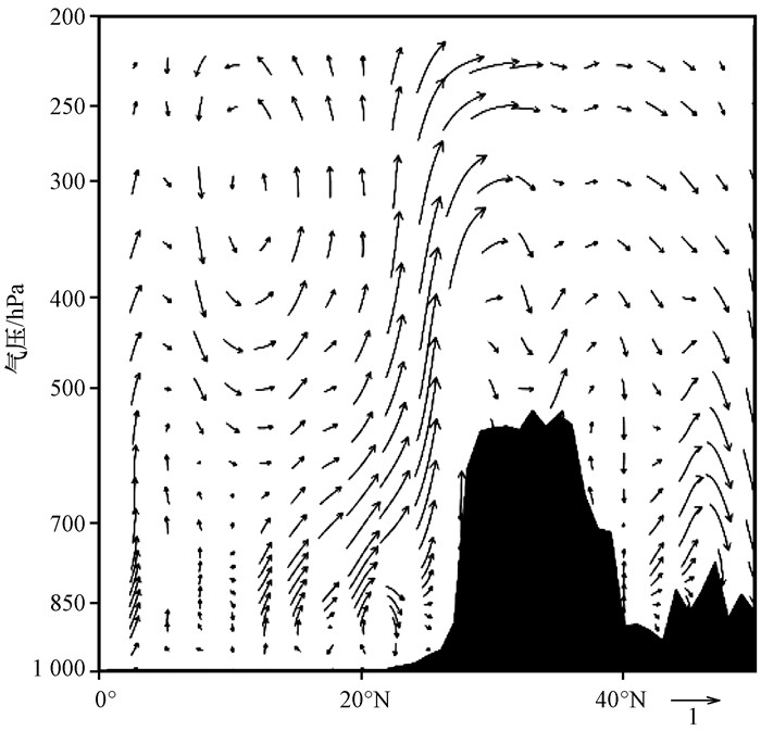
通过对90°E—100°E潜热通量高低年风矢量差值高度纬度剖面(图 12)进行分析, 同样可以看到高原潜热偏多年南侧孟加拉湾海域对流层低层气流具有明显增强的抬升运动, 并在上文所描述气旋的作用下, 形成了携带丰富水汽的偏经向风异常, 该经向风在高原南部受地形因素影响逐步抬升, 并有部分到达高原上空, 有利于提高高原气柱可降水量、增强高原春季降水从而使高原潜热通量增强。
|
图 12 90°E—100°E潜热高年与潜热低年风场差值(单位: m·s-1)高度-纬度剖面 黑色阴影区为青藏高原地形 Figure 12 Difference of wind vector averaged from 90°E—100°E between LH-High years and LH-Low years.Unit: m·s-1. The black shaded represents the topography of QTP |
通过对高原地表热通量的时空分布特征, 年际变化趋势的分析, 深入研究探讨了春季高原上空西风急流变化与高原感热和潜热间的联系, 并得出以下结论:
(1) 高原地表热通量以感热通量为主, 除受夏季西南季风的影响潜热通量高于感热通量外, 其余三个季节高原感热都强于高原潜热。感热通量与潜热通量空间分布呈反相分布, 分别为自西北向东南递减和递增。
(2) 从长期变化趋势来看, 高原春季热通量变化较明显。其中感热具有显著的减弱趋势, 主要分为两个阶段, 1994年之前与之后分别呈持续性减弱与波动式减弱特征。春季潜热在气候量值较低的情况下, 增率达到0.79 W·m-2·(10a)-1, 说明潜热增强趋势显著。同时春季感热与潜热年际变化间存在着明显的负相关, 说明可能存在某一气候因子同时影响着对感热和潜热的变化。通过对高原感热影响因素的分析, 发现高原感热通量的降低趋势是对高空西风急流减弱的响应。
(4) 分析表明孟加拉湾上空异常气旋环流的形成背景是高原西风急流减弱。在该气旋的作用下使该地区对流增强、水汽上升异常, 同时气旋中北向暖湿气流将水汽携带至高原, 为高原提供更多水汽, 使高原中东部大部分地区水汽含量增加并通过影响高原降水量改变其潜热通量。
综上, 从高原感热通量和潜热通量变化间的联系出发, 建立了西风急流对高原地表热力特征可能影响机制, 即西风急流减弱使高原地表风速减弱的同时, 伴随着印度洋海温升高, 在孟加拉湾上空形成一异常气旋, 共同影响着高原的感热及潜热变化。该机制的建立为进一步探讨西风急流对高原热力作用影响以及气候效应提供了基础。数值模拟与观测资料的结合将是我们下一步研究的重点。
Avissar R, Schmidt T. 1998. An evaluation of the scale at which ground-surface heat flux patchiness affects the convective boundary layer using large-eddy simulations[J]. J Atmos Sci, 55(16): 2666–2689.
DOI:10.1175/1520-0469(1998)055<2666:AEOTSA>2.0.CO;2 |
|
Chen S, Huang J, Zhao C, et al. 2013. Modeling the transport and radiative forcing of Taklimakan dust over the Tibetan Plateau:A case study in the summer of 2006[J]. J Geophys Res, 118(2): 797–812.
|
|
Diaz H F, Bradley R S, 1997. Temperature variations during the last century at high elevation sites[M]. Climatic change at high elevation sites. Springer Netherlands.
|
|
Duan A, Wu G X. 2005. Role of the Tibetan Plateau thermal forcing in the summer climate patterns over subtropical Asia[J]. Climate Dyn, 24(7/8): 793–807.
|
|
Duan A, Wu G. 2008. Weakening trend in the atmospheric heat source over the Tibetan Plateau during recent decades.Part Ⅰ:Observations[J]. J Climate, 21(13): 3149–3164.
DOI:10.1175/2007JCLI1912.1 |
|
Duan A, Wu G. 2009. Weakening trend in the atmospheric heat source over the Tibetan Plateau during recent decades.Part Ⅱ:connection with climate warming[J]. J Climate, 22(15): 4197–4212.
DOI:10.1175/2009JCLI2699.1 |
|
Li G P, Duan T Y, Wan J, et al. 1996. Determination of the drag coefficient over the Tibetan Plateau[J]. Adv Atmos Sci, 13(4): 511–518.
DOI:10.1007/BF03342041 |
|
Hu Z Y, Cheng G D, Qian Z Y, et al. 2004. Cooling effect of ballast revetment on the roadbed of Qinghai-Tibetan Railway[J]. Sci China (Earth Sci), 47(S1): 161–167.
|
|
Huang F F, Ma W Q, Wang B B, et al. 2017. Air Temperature Estimation with MODIS Data over the Northern Tibetan Plateau[J]. Adv Atmos Sci, 34(5): 650–662.
DOI:10.1007/s00376-016-6152-5 |
|
Lau K M, Kim M K, Kim K M. 2006. Asian summer monsoon anomalies induced by aerosol direct forcing:the role of the Tibetan Plateau[J]. Climate dynamics, 26(7/8): 855–864.
|
|
Li X Z, Zhou W. 2016. Modulation of the interannual variation of the india-burma trough on the winter moisture supply over southwest china[J]. Climate Dyn, 46(1/2): 147–158.
|
|
Liu X D, Chen B D. 2000. Climatic warming in the Tibetan plateau during recent decades[J]. Int J Climatol, 20(14): 1729–1742.
DOI:10.1002/(ISSN)1097-0088 |
|
Ma W Q, Ma Y M. 2016. Modeling the influence of land surface flux on the regional climate of the Tibetan Plateau[J]. Theor Appl Climatol, 125(1): 45–52.
|
|
Ma W Q, Ma Y M, Ishikawa H. 2014. Evaluation of the SEBS for upscaling the evapotranspiration based on in-situ observations over the Tibetan Plateau[J]. Atmos Res, 138(3): 91–97.
|
|
Ma W Q, Ma Y M, Li M S, et al. 2009. Estimating surface fluxes over the north Tibetan Plateau area with ASTER imagery[J]. Hydrol Earth Syst Sci, 13(1): 57–67.
DOI:10.5194/hess-13-57-2009 |
|
Ma W Q, Ma Y M, Su B. 2011. Feasibility of retrieving land surface heat fluxes from ASTER data using SEBS:A case study from the NamCo area of the Tibetan Plateau[J]. Arctic Antarctic & Alpine Research, 43(2): 239–245.
|
|
Ma Y M, Ma W Q, Zhong L, et al. 2017. Monitoring and modeling the Tibetan Plateau's climate system and its impact on East Asia[J]. Scientific Reports, 7: 44574.
DOI:10.1038/srep44574 |
|
Ma Y M, Zhong L, Tian H, et al. 2006. Study on the regional land surface heat fluxes over heterogeneous landscape of the Tibetan Plateau area[J]. J Remote Sens, 10(4): 542–547.
|
|
Rangwala I, Miller J R, Russell G L, et al. 2010. Using a global climate model to evaluate the influences of water vapor, snow cover and atmospheric aerosol on warming in the Tibetan Plateau during the twenty-first century[J]. Climate Dyn, 34(6): 859–872.
DOI:10.1007/s00382-009-0564-1 |
|
Rangwala I, Miller J R, Ming X. 2009. Warming in the tibetan plateau:possible influences of the changes in surface water vapor[J]. Geophys Res Lett, 36(6): 295–311.
|
|
Schneider U, Fuchs T, Meyer-Christoffer A, et al, 2008. Global precipitation analysis products of the GPCC[R/OL]. Global Precipitation Climatology Centre (GPCC), DWD, Internet Publikation, 112. http://www.mapcruzin.com/environmental-shapefile-aps/water/precipitation/GPCC_intro_products_2008.pdf. [2017-04-08].
|
|
Shi Q, Liang S. 2014. Surface-sensible and latent heat fluxes over the Tibetan Plateau from ground measurements, reanalysis, and satellite data[J]. Atmos Chem Phys, 14(11): 5659–5677.
DOI:10.5194/acp-14-5659-2014 |
|
Simmons A, Uppala S, Dee D, et al. 2007. ERA-Interim:New ECMWF reanalysis products from 1989 onwards[J]. ECMWF Newsletter, 110: 25–35.
|
|
Sun G H, Hu Z Y, Sun F L, et al. 2017. An analysis on the influence of spatial scales on sensible heat fluxes in the north Tibetan Plateau based on Eddy covariance and large aperture scintillometer data[J]. Theor Appl Climatol, 129(3/4): 965–976.
|
|
Wu G, Yao T, Xu B, et al. 2010. Dust concentration and flux in ice cores from the Tibetan Plateau over the past few decades[J]. Tellus B, 62(3): 197–206.
DOI:10.1111/j.1600-0889.2010.00457.x |
|
Wu T W, Qian Z A. 2003. The relation between the Tibetan winter snow and the Asian summer monsoon and rainfall:An observational investigation[J]. J Climate, 16(12): 2038–2051.
DOI:10.1175/1520-0442(2003)016<2038:TRBTTW>2.0.CO;2 |
|
Yanai M, Li C, Song Z. 1992. Seasonal heating of the Tibetan Plateau and its effects on the evolution of the Asian summer monsoon[J]. J Meteor Soc Japan, 70(1B): 319–351.
DOI:10.2151/jmsj1965.70.1B_319 |
|
Yang K, Guo X F, Wu B Y. 2011. Recent trends in surface sensible heat flux on the Tibetan Plateau[J]. Sci China(Earth Sci), 54(1): 19–28.
|
|
金蕊, 祁莉, 何金海. 2016. 春季青藏高原感热通量对不同海区海温强迫的响应及其对我国东部降水的影响[J]. 海洋学报, 38(5): 83–95.
Jin R, Qi L, He J H. 2016. Effect of oceans to spring surface sensible heat flux over Tibetan Plateau and its influence to East China preciptation[J]. Acta Oceanologica Sinica, 38(5): 83–95.
|
|
李栋梁, 何金海, 汤绪, 等. 2007. 青藏高原地面加热场强度与ENSO循环的关系[J]. 高原气象, 26(9): 36–45.
Li D L, He J H, Tang X, et al. 2007. The relationship between the intensity of surface heating fields over the Qinghai-Xizang Plateau and ENSO cycle[J]. Plateau Meteor, 26(9): 36–45.
|
|
刘超, 刘屹岷, 刘伯奇. 2015. 6种地表热通量资料在伊朗-青藏高原地区的对比分析[J]. 气象科学, 35(4): 398–404.
Liu C, Liu Y M, Liu B Q. 2015. Comparison of six sensible heat flux datasets over the Iranian-Tibetan Plateaus[J]. J Meteor Sci, 35(4): 398–404.
DOI:10.3969/2014jms.0038 |
|
王美蓉, 周顺武, 段安民. 2012. 近30年青藏高原中东部大气热源变化趋势:观测与再分析资料对比[J]. 科学通报, 57(Suppl): 548–557.
Wang M R, Zhou S W, Duan A M. 2012. Trend in the atmospheric heat source over the central and eastern Tibetan Plateau during recent decades:Comparison of observations and reanalysis data[J]. Chinese Sci Bull, 57(Suppl): 548–557.
|
|
吴国雄, 刘屹岷, 刘新, 等. 2005. 青藏高原加热如何影响亚洲夏季的气候格局[J]. 大气科学, 29(1): 47–56.
Wu G X, Liu Y M, Liu X, et al. 2005. How the heating over the Tibetan Plateau affects the Asian climate in summer[J]. Chinese J Atmos Sci, 29(1): 47–56.
|
|
叶笃正, 张捷迁. 1974. 青藏高原加热作用对夏季东亚大气环流影响的初步模拟实验[J]. 中国科学(地球科学), 25(3): 397–420.
Ye D Z, Zhang J Q. 1974. A preliminary experimental simulation the heating effect of the Tibetan Plateau on the general circulation over Eastern Asia in summer[J]. Sci China (Earth Sci), 25(3): 397–420.
|
|
于琳琳, 陈海山. 2012. 青藏高原4月陆面状况和地表加热异常与中国夏季降水的联系[J]. 高原气象, 31(5): 1173–1182.
Yu L L, Chen H S. 2012. Possible linkages among anomalous land surface condition surface heating in Qinghai-Xizang Plateau in April and summer precipitation in China[J]. Plateau Meteor, 31(5): 1173–1182.
|
|
张浩鑫, 李维京, 李伟平. 2017. 春夏季青藏高原与伊朗高原地表热通量的时空分布特征及相互联系[J]. 气象学报, 75(2): 260–274.
Zhang H X, Li W J, Li W P. 2017. Spatial and temporal distribution characteristics of surface heat fluxes over both Tibetan Plateau and Iranian Plateau in boreal spring and summer and their relationships[J]. Acta Meteor Sinica, 75(2): 260–274.
DOI:10.11676/qxxb2017.002 |
2. Institute of Tibetan Plateau, Chinese Academy of Sciences, Beijing 100101, China;
3. Chinese Academy of Sciences Center for Excellence in Tibetan Plateau Earth Sciences, Beijing 100101, China;
4. Nanjing University of Information Science and Technology, Nanjing 210000, Jiangsu, China
 2018, Vol. 37
