
Uncertainties in the Regional High-Resolution Land Surface Simulations

  • Yanhong GAO 1 ,
  • Wei LIU 2 ,
  • Li ZENG 3
Expand
  • 1Institute of Atmospheric Sciences & Department of Atmospheric and Oceanic Sciences, Fudan University, Shanghai 200438, China
  • 2Meteorological Center of East China Air Traffic Administration, Civil Aviation Administration of China, Shanghai 200335, China
  • 3Key laboratory of Land Surface Process and Climate in Cold and Arid Regions, Northwest Institute of Eco-Environment and Resources, Chinese Academy of Sciences, Lanzhou 730000, Gansu, China

Received date: 2021-04-03

  Revised date: 2021-06-16

  Online published: 2021-12-28

Highlights

Land is an important part of the earth's climate system and an important place for human life.Water resources, ecosystems and human activities over land are all affected by global climate systems and are sensitively respond to climate changes.At the same time, as the lower boundary for the climate system, land exerts an important feedback on regional weather and climate system.Therefore, accurate, and high-resolution land surface simulation is an important prerequisite for simulating weather climate events and correctly understanding weather climate phenomenon.However, there is still great uncertainty in modern land surface processes simulations.The uncertainty of land surface process simulation comes from three aspects: model physical process, surface characteristic parameters, and meteorological driven data.This study summarizes the sources of uncertainty in high - resolution simulations of land surface processes, especially in high altitude mountains, focusing on the important impact of heterogeneous distribution characteristics of precipitation data on land surface process simulation.Improving land surface process model, providing realistic distribution of surface characteristic parameters, and carrying out dynamical downscaling simulation at convection permitting scale based on the high-resolution land surface statements may be an effective way to improve precipitation simulation for complex terrains.We aim to accurately simulate regional water circulation and realize the ultimate purpose of land surface process and regional climate simulation.

Cite this article

Yanhong GAO , Wei LIU , Li ZENG . Uncertainties in the Regional High-Resolution Land Surface Simulations[J]. Plateau Meteorology, 2021 , 40(6) : 1364 -1376 . DOI: 10.7522/j.issn.1000-0534.2021.zk008

1 引言

除大气圈和岩石圈外, 地球气候系统中绝大部分生物繁衍和生产生活都发生在地球表面。陆地是人类赖以生存的重要活动场所, 为我们提供了必需的粮食、 淡水、 能源以及表层生态系统。因此, 陆地对全球变化的响应研究受到了广泛而持续的关注。陆面过程研究就是解决与人类社会最密不可分的陆地表层圈层的相互作用, 它是一个典型的多学科交叉融合的研究领域(戴永久, 2020)。
陆面数值模式是研究陆面过程以及陆气相互作用的强有力工具, 是描述陆地表面地球物理、 化学、 生物、 水文等过程的数值模型。40年来, 它经历了从最初的第一代水箱模式, 发展到考虑植被蒸散发等生理过程以及植被影响辐射传输的第二代-BATs (Biosphere-Atmosphere Transfer Scheme) (Dickinson et al, 1993)、 SIB2 (the Simple Biosphere Model) (Sellers et al, 1996)、 SSiB (the Simplified SIB) (Xue et al, 1996)、 CLM3.0 (the Community Land Model version 3.0)(Oleson et al, 2004)和Noah(Chen and Dudhia, 2001)等, 到进一步考虑物理生化和呼吸过程的第三代(CLM4.5, https: //www.cesm.ucar.edu/models/cesm1.2/clm/models/lnd/clm/doc/UsersGuide/f101.html), 再到包含更详细子模块的第四代(CLM5, https: //www.cesm.ucar.edu/models/cesm2/land/; Noah-MP, https://ral.ucar.edu/sites/default/files/public/projects/wrf-hydro-modeling-system/noah-mp-tutorial-20170501.pdf) 等, 现代的陆面过程模式已经有了长足的进步, 大致可以描述陆面的基本地球物理、 化学、 生物和水文等过程。
早期的陆面过程研究旨在发展、 检验和完善陆面过程模式, 大多使用定点陆面和边界层加强观测资料验证和率定陆面过程模式(Ji, 1995Xue et al, 1996Yang et al, 1997)。近几十年来, 以气候变暖为标志的全球环境变化持续发生, 对人类赖以生存的生态环境产生了重大影响, 导致森林面积减小、 土地退化与荒漠化、 水土流失、 自然灾害急剧增加等负面后果(朱连奇和许立民, 2011水利部黄河水利委员国际合作与科技局, 2008符淙斌和马柱国, 2008Zeng et al, 2003Yang et al, 2004Scholes, 2016)。随着陆面过程模式的逐步完善和全球变化与陆地生态系统研究的开展, 现代陆面过程模式, 包括各种分布式水文模型和生态模型, 被广泛用于分析气候变化对陆地水文和生态系统的影响, 以及预测未来全球变化可能带来的农业、 林业、 土壤和生态系统复杂性的改变(Ruiz-Barradas and Nigam, 2006Margulis et al, 2002Mitchell, 2004Nunes et al, 2012Xue et al, 2021)。全球变化研究对陆面过程模拟提出了更大的挑战(Broxton et al, 2016Wang et al, 2016)。

2 陆面过程模拟不确定性的主要来源

陆面过程模拟的不确定性主要来源于三个方面: 模式物理过程、 地表特征参数、 气象驱动数据。下文分别予以介绍。

2.1 模式物理过程

陆面过程模式发展阶段, 尤其是模式发展初期, 物理过程正确描述的重要性排在首位。使用定点加强观测数据作为气象驱动数据, 使用定点观测的地表特征参数, 开展地表能量和水分通量的模拟, 并与定点监测数据进行比较(Yang, 2005Zhao et al, 2006Yang et al, 2009a)。这种研究方法可以最大程度保证驱动数据和地表特征参数的准确性, 是用于发展和改进模式物理过程的有效途径。
20世纪80~90年代, 陆面过程研究大多采用上述方法。这种方法需要全套的陆面过程加强观测数据支撑, 尤其是地表通量的观测。陆面加强观测成为人类认识陆气相互作用的重要途径。于是, 80年代以后, 全球范围开展了一系列大型国际陆面观测试验研究和计划, 如美国的the First ISLSCP (International Satellite Land Surface Climatology Project) Field Experiment (FIFE) project, 法国的 the Hydrologic Atmospheric Pilot EXperiment (HAPEX-MOBILHY), 欧洲的ECHIVAL Field Experiment in a Desertification Threatened Area (ECHIVAL-EFEDA), the Global Energy and Water Cycle Experiment Continental-Scale International Project(GEWEX-GCIP), the Global Energy and Water cycle EXperiment, the GEWEX Asian Monsoon Experiment (GEWEX-GAME), 亚马逊的The Large-scale Biosphere-Atmosphere Experiment in Amazonia (LBA), 中国的黑河试验(the Heihe)和内蒙古半干旱草原土壤植被大气相互作用(IMGRASS)等。早期研究多基于气象要素梯度观测资料计算地表通量(Yang et al, 2009b), 后来随着观测设备的发展, 涡动相关观测被大量使用(Zhang et al, 2010Zhou et al, 2017a), 有些大型试验还采用通量观测矩阵开展研究(Li et al, 2018)。
基于这些大型观测试验, 陆面过程模式得以逐步发展和完善。最具代表性的陆面过程模式包括BATS (Dickinson et al, 19861993)、 SiB (Sellers et al, 19861996)、 IAP-LSM-1994 (IAP Land Surface Processes Model version 1994) (Dai and Zeng, 1997)、 AVIM (Atmosphere Vegetation Interaction Mode) (Ji and Hu, 1989Ji, 1995)、 Noah (Chen and Dudhia, 2001)。这一阶段陆面模式最显著的特点是细致地考虑了植被在陆地水热过程中的作用, 包括对辐射传输、 动量交换、 蒸腾、 降水截流等过程的影响。20世纪90年代, 光合作用、 呼吸作用等关键的植被生理与生态系统过程也囊括其中。
现代的通用陆面过程模式大我源于此, 并加入大量新的子模式, 包含的过程更加完备, 对陆面物理、 化学和生物等过程的描述已经比较完备(戴永久, 2020)。但是, 高海拔山区富含冰雪, 物理过程较平原区更为复杂, 全球通用陆面过程模式对高海拔地区冰冻圈物理过程的描述存在不足(Yang et al, 2018Zheng et al, 2017)。近年来, 针对这一不足开展了不确定性研究, 高海拔山区陆面过程的优化和改进取得了一些进展, 举例如下:
针对陡峭地形, Gao et al (2004)将三维地表水文过程与中尺度大气模式耦合, 研究了青藏高原边缘流域地表侧向流对天气/气候的影响(高艳红等, 2006); Zhou et al (2017b)认为地形拖曳方案的加入可以减小青藏高原地表风速和地表气温的模拟误差。针对土壤湿度模拟偏差, Pan et al (2017)针对青藏高原土壤粒径较粗的特征, 发展了砾石参数化方案, 使得土壤湿度模拟误差减小25%。Gao et al (2015c)根据青藏高原植被特征和实验室研究发现高寒植被短浅根系参数化方案的加入可以极大地改进表层土壤湿度模拟, 同时显著提高蒸散发模拟性能。
青藏高原湖泊众多, 而且近年来湖泊面积扩大, 湖泊数量增多, 这对陆表类型构成产生了较大影响。Gao et al (2020b)发现如果在中尺度模式中使用最近点海温作为湖表温度, 模拟会显著高估湖泊附近地区降水。Wen et al (2016)研究发现相比周边陆地, 湖泊具有较高的地气温差, 对边界层结构有一定影响。Gao et al (2020b)改用地气温差校准的近地面气温后显著减小了降水模拟误差。湖泊盐分和浅表水纹波对湖气相互作用的影响也受到关注(Wen et al, 2015b2016)。一些研究将参数化的动态湖泊过程模式与中尺度天气模式耦合, 用于湖泊的区域气候效应研究(Gu et al, 2013Huang et al, 2019Wen et al, 2015a)。
积雪反馈是陆气相互作用的重要组成部分(Pepin et al, 2015Douville, 2009Xiao and Duan, 2016Letcher and Minder, 2015Gao et al, 2018)。Jiang et al (2019)分析了五套积雪观测数据, 发现青藏高原积雪减薄且持续时间较短的特点。使用最新一代的Noah-MP默认参数化方案的模拟结果显著高估了积雪覆盖度, 这可能是青藏高原气温模拟冷偏差的一个重要原因。针对这一问题, 使用优化的积雪参数化方案, 显著减小了积雪模拟偏差(Jiang et al, 2020)。使用动力降尺度模拟的降水数据作为陆面模拟的驱动数据, 进一步精细刻画了藏东南地区高海拔山区的积雪分布特征(Gao et al, 2020a)。
平原区的典型陆面过程参数化的发展也取得一些新进展。典型代表是城市和农田模块的发展。农田, 作为一种重要的人工植被模块, 成为陆面过程模式近年来快速发展的方向, 全球广泛使用的几个陆面过程模式都不同程度地研发了农田模块, 例如, CLM模式从4.0版本开始发展农田模块(Oleson et al, 2013), 5.0版本中, 耦合了一个全新的功能组装的陆地生态系统模拟器(Functionally Assembled Terrestrial Ecosystem Simulator, FATES)(Lawrence et al, 2020)。Noah-MP模式中也研发了农田模块(Liu et al, 2016Zhang et al, 2020)。
城市冠层模型一直是陆面过程模式的研发焦点之一(Chen et al, 2011Wang et al, 2019Li et al, 2019)。随着变暖的加剧, 城市热岛效应越来越强烈, 复合高温热浪事件频发, 对人类健康造成了极大的威胁。一些国家和地区从陆面过程反馈机理角度, 采取了一定措施, 可以在一定程度减缓城市热岛效应(Shashua-Bar et al, 2009Middel et al, 2014Estoque et al, 2017Roy et al, 2012Stovin et al, 2012)。在我国, 运用陆面过程研究理论指导城市化发展方面研究还相对薄弱。新一代模式研发将进一步精细刻画下垫面各种地表要素的非均匀分布, 建立包含人类活动(城市化、 植树造林、 森林砍伐、 灌溉等)的高分辨率全球陆面过程模式, 并与其他学科相结合, 形成跨领域的综合预报预测系统或研究方法和工具(戴永久, 2020)。

2.2 地表特征参数

模式研发初期, 为了减小物理过程以外的要素干扰, 地表特征参数以观测点实测为主, 使用实测气象要素作为驱动数据, 进行模式的单点测试。实地气象和地表特征观测数据的使用使得陆面过程模拟误差仅限于模式物理过程, 该方法对陆面过程模式的研发起到了非常重要的作用。但同时, 由于所有观测仅限于该监测点, 由于地表特征的高度非均匀分布, 该点研究结果的空间代表性有限。
为了研究全球或区域陆表水文过程, 国际上开展了一系列研究计划 [如: Global Soil Wetness Project (GSWP), Global Land Data Assimilation System (GLDAS)等], 使用气象数据驱动陆面或水文模式, 以离线方式进行模拟成为地表环境对全球变化响应研究的主要手段, 全球或区域地表土壤和植被特征数据成为必须。The Advanced Very High Resolution Radiometer (AVHRR)土地覆盖/利用类型产品, The Food and Agriculture Organization (FAO)土壤类型数据, 植被覆盖度被广泛使用。同时, 研究发现全球通用地表特征数据集中的植被和土壤特征与某些区域实际观测结果存在较大差异, 对模拟结果有很大影响, 准确的网格化地表特征参数成为限制陆面过程非均匀性模拟的重要因素(Chen et al, 2007Wei et al, 2014)。在地形复杂地区, 由于地表特征尺度远小于平坦地区, 对地表特征数据提出了更高要求。另外, 随着社会的发展和人类活动强度的增大, 土地覆盖/利用变化迅速, 地表特征参数不能得以及时更新, 也限制了陆面过程的准确模拟。比如, 京津冀、 长三角和珠三角地区的快速城市化在早期的AVHRR数据是无法体现的。
于是, 一些研究团队从解决基础数据入手, 研发了本土化的地表特征参数数据集, 提高了研究区域的地表能量和水分交换的模拟性能。例如, 中山大学陆面过程研究小组基于世界、 区域和国家的土壤图和土壤剖面数据库, 研发了1 km分辨率的全球土壤和有机质数据集(李文耀等, 2020Shangguan et al, 2014Dai et al, 2019)。高艳红等(2007)刘伟等(2007)研发了适合黑河流域的土壤质地、 土地利用和植被覆盖度数据。研究表明, 本土化的地表特征数据集可以显著提高陆面过程模拟性能(李文耀等, 2020吴龙刚等, 2014Gao et al, 2008)。随着高分辨率地表遥感产品的推成出新、 以及全球变化和地球表层系统研究的不断进步, 越来越多的卫星遥感数据被用于陆面过程模拟。

2.3 气象驱动数据

陆面过程模式发展早期, 多使用加强观测期气象观测资料驱动陆面过程模式, 使用同期地表热量和水分交换通量观测资料验证模拟结果, 因而不存在驱动数据不确定性导致的模拟误差(Chen et al, 1996Swenson and Lawrence, 2012Zhong et al, 2011Liu et al, 2005Yang et al, 2014)。随着全球变化日益成为显学, 越来越多的研究需要区域或全球范围的陆面过程模拟, 因而网格化气象驱动数据的需求被提上日程, 高分辨率陆面数据同化系统对驱动数据提出了更高的时空分辨率需求(Mitchell, 2004Chen et al, 2009Fang, 2009)。
早在21世纪初, Guo et al (2006) 基于第二次全球土壤湿度比较计划, 提出土壤湿度模拟的准确性很大程度上依赖于气象驱动数据的准确性, 全球尺度而言, 驱动数据引起的误差甚至和模式误差相当。在青藏高原中部研究中Gao et al (2015c)对比了分别使用站点观测和网格化降水数据驱动陆面过程模式Noah LSM, 发现使用站点观测资料驱动的蒸散发和径流模拟结果明显优于使用网格化驱动数据的模拟结果(图1), 认为驱动数据的不确定性对陆地水循环研究的影响甚至大于陆面模式物理过程和地表特征参数的影响(Gao et al, 2015c)。在典型农田覆盖区, Zhang et al (2016)也发现降水数据对Noah-MP模拟的地表通量的影响大于地表特征参数的影响。武洁等(2020)对比地面观测资料, 分析了全球陆面数据同化产品GLDAS和高分辨率陆面过程模拟的青藏高原土壤湿度, 发现基于常规气象观测资料插值的网格化降水资料难以体现空间非均匀性, 是影响土壤湿度模拟性能的重要因素之一。
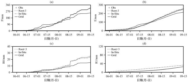
图1 GAME加强观测期间安多站观测和中国气象驱动数据(CMFD)最近网格的累积降水(P)(a)、 使用站点观测和格点降水数据模拟的累积蒸散发(E)(b)、 地表累积径流量(R0)(c)和地下累积径流量(R1)(d)(引自Gao et al, 2015c

Fig.1

The accumulative precipitation at the <i>in-situ</i> Amdo Station and the precipitation (P) at the nearest grid in the observation-based precipitation product CMFD to the Amdo Station in the GAME enhanced observation period (a), simulated cumulative evapotranspiration (E) (b), cumulative surface runoff (R0) (c), and cumulative underground runoff (R1) (d) driven by the in-situ and gridded precipitation data (From <a href="javascript:;" class="mag_content_a" onclick="piaofuRef(this,'R30')" rid="R30">Gao et al, 2015c</a>)
诸多研究表明, 陆面过程模拟所需气象驱动要素(降水、 2 m气温、 2 m相对湿度、 气压、 向下短波和长波辐射、 10 m风场经向风、 纬向风分量等, 不同模式所需要素可能不同)中, 降水数据对模拟结果的影响最大(Gao et al, 2015c2020aZhang et al, 2016Yoon et al, 2019武洁等, 2020Wang and Zeng, 2011Vionnet et al, 2019Immerzeel et al, 2014)。Guo et al (2006)指出全球平均而言, 降水、 地表辐射以及植被类型对土壤湿度的模拟影响较大, 而在东亚地区, 降水是最主要的影响因素。降水数据的不确定性成为阻碍陆面/水文模拟的瓶颈。在地形复杂地区, 例如青藏高原, 受自然条件限制, 观测站点主要分布在中东部地形比较平坦的地区。而且处于安全考虑, 观测设备大多安装在山谷中, 站点观测的代表性有限, 这些客观条件都严重地限制了基于观测的网格化降水产品的准确性(Gao et al, 2015bGao and Chen, 2017)。然而, 降水多产生于山区, 尤其是被称为亚洲水塔的青藏高原, 近年来气候变化强烈地影响了地表环境变化(姚檀栋等, 2015Chen et al, 2015), 稀疏的观测站点分布和高分辨率网格化降水数据匮乏的矛盾尤为突出(图2), 地表环境的模拟对降水数据准确性的需求尤为迫切。
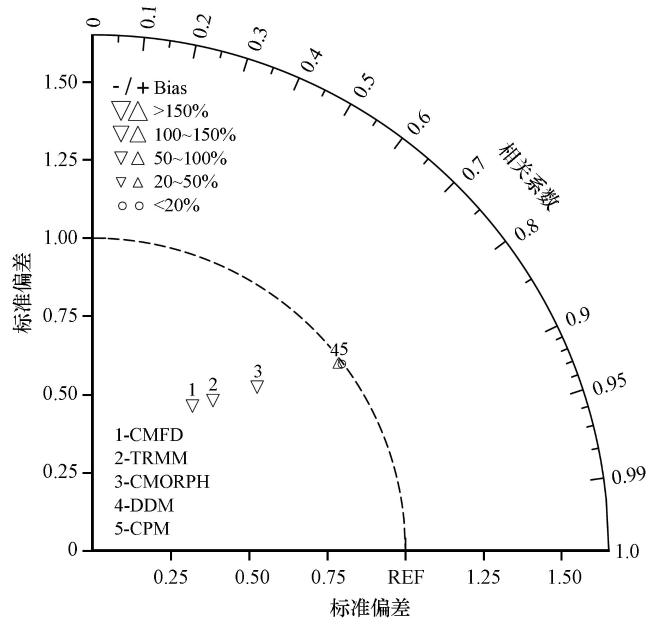
图2 高分辨率陆面数据同化系统(HRLDAS)模拟的2013年10月至2014年5月的积雪覆盖度与MODIS产品比较的泰勒图

模拟结果使用基于观测的三套降水产品(CMFD、 TRMM、 CMORPH)和两套基于气候模式的动力降尺度(DDM和CPM)模拟结果作为降水驱动数据 (来自Gao et al, 2020a

3 降水驱动数据的不确定性

降水是地球系统唯一的淡水来源, 是联系地表水循环和大气水循环的桥梁, 是水循环诸多要素中最重要的因子。它与蒸发、 径流、 水储量变化等地表水循环要素以及水汽输送等大气水循环要素一起, 共同构成了地球水循环系统。
越来越多的研究表明, 尽管陆面过程模式持续改进其模拟地表热通量和水文分量的能力, 但降水数据的准确性一直是离线模拟的瓶颈(Adam and Lettenmaier, 2003)。这种矛盾在物理过程高度复杂的高海拔山区尤其严重(Gao et al, 2015c2017Immerzeel et al, 2015)。首先, 高海拔山区富含冰雪, 物理过程较平原区更为复杂, 全球通用陆面过程模式对高海拔地区冰冻圈物理过程的描述还存在诸多不足(Yang et al, 2018Zheng et al, 2017); 其次, 由于自然条件限制, 青藏高原缺乏准确观测(包括气象观测和其它地表特征数据的观测), 使得青藏高原陆面过程模拟研究缺乏有力的数据支撑(Gao et al, 2015cZhang et al, 2016Yoon et al, 2019)。这些都给青藏高原陆面过程的研究带来了极大的不确定性。
全球范围降水产品有CMORPH, GPM, PERSIANN。在我国, 使用比较广泛的有中科院青藏高原研究所开发的CMFD, 中国气象局开发的中国陆面数据同化系统(CLDAS)降水产品, 中山大学陆面过程研发团队建立的5 km分辨率陆面过程驱动数据集, 还有其它各研究团队根据各自研究需要制作的区域降水驱动数据等。总体来说, 网格化降水产品按照数据源大体可分为三类: 地面监测插值产品、 卫星遥感反演产品和全球气候模式产品。三种数据制作方法各有优缺点: 站点监测位置最为准确, 但是受监测范围和环境因素影响, 区域代表性受到限制; 卫星反演产品可以提供大范围监测数据, 但是反演算法受多方面制约, 需要订正, 数据准确性受到影响; 气候模式产品基于大气动力和物理过程, 可以获得区域尺度降水产品, 但是存在模拟误差。
(1) 地面降水观测。地面观测是获取准确降水数据的基本保障。但是, 我国气象台站分布不规则, 中东部地区分布比较密集, 而在西部则分布稀疏, 而且受地形条件限制, 观测仪器多位于山谷中, 复杂的地形限制了站点数据的区域代表性(Gao et al, 2015b); 再者, 常规气象台站最高海拔位于4800 m, 海拔5000 m以上没有常规气象观测, 这一分布决定了常规气象观测数据更多反映的是青藏高原中东部地区的山谷气候, 通过插值方法获得的网格降水资料对广大的西部高海拔地区以及中东部山顶位置的降水准确性有待研究(Gao et al, 2018)。
高海拔地区降水数据的准确性问题已经引起了地学领域研究学者的广泛关注, Hu et al (2018)指出所有基于观测的网格化降水产品(GPCP, GPCC, CRU, WM)在青藏高原都存在显著低估。高海拔地区降水与平原区最大的不同是高海拔地区降水多以固态降水为主, 而平原区以液态降水为主。再者, 由于常年平均气温在零度以下, 高海拔地区水资源也以固态储存(积雪、 冻土、 冰川)方式为主。这一显著差别导致青藏高原水循环的复杂程度远远大于平原区。早在20世纪90年代末, Goodison et al (1998)在世界气象组织固态降水观测比较报告(WMO Solid Precipitation Measurement Intercomparison final report)仪器和观测方法67号报告中基于全世界12个国家上百个观测站点研究, 指出高海拔地区的降水观测存在显著低估, 动力损失以及蒸发和湿润损失是导致低估的三个重要因素, 并认为对雨量计进行三层遮蔽可以提高降水量监测的准确性。鉴于各种原因, 三层遮蔽方法未能广泛实施。之后, Ye et al (2004)Yang et al (2005)针对中国范围降水观测数据提出了偏差校准方法, 发现中国范围常规气象站监测年平均降水量普遍低估6%~62%(平均19%), 月降水趋势低估5%~20%。Immerzeel et al (2015)在印度河流域的研究也指出高海拔降水量存在严重低估现象。总之, 青藏高原降水观测数据存在很大的不确定性。
(2) 卫星遥感反演。由于地面监测站点的代表范围有限, 卫星遥感反演为大范围降水监测提供了有力补充(Yoon et al, 2019)。然而, 卫星遥感降水产品在正演或反演的过程中受算法影响, 存在显著系统偏差。
卫星反演算法多为经验公式或拟合结果, 算法以及所用参数存在较大不确定性。例如, 云是卫星产品识别中的重要影响因素, 不同的去云方法对产品准确性的影响极大(Hall et al, 1995Jiang et al, 2019)。诸多卫星气象研究人员终生致力于反演算法的优化, 以期提供高质量的降水产品, 但是, 由于主要受到两方面的限制, 现有的降水产品在青藏高原的适用性还有待提高: 一是反演算法, 二是订正仍然极大地依赖地面观测数据。以众所周知的TRMM卫星为例, 常用的TRMM降水有3A43, 3B42, 3B42RT, 不同产品的准确性不同, 其中3A43降水产品得到了全世界的广泛认可, 然而, 诸多研究表明该产品在青藏高原仍然存在显著低估(Hu et al, 2018)。
近年来出现各种降水产品多为地面观测融合卫星, 全球范围的降水产品有CMORPH, GPM, PERSIANN。亚洲和中国范围有日本开发的APHRODITE, 中科院青藏高原研究所开发的CMFD, 中国气象局开发的CLDAS, 还有水文学家根据各自研究需要制作的区域降水驱动数据等(Cuo et al, 2016)。这些降水产品在青藏高原表现各有优劣, 总体来说受到地面监测数据和卫星反演算法的双重影响, 这些融合降水产品在青藏高原仍然存在很大的不确定性(Tong et al, 2014Wu and Zhai, 2013Ma et al, 2016Gao and Liu, 2013Chen et al, 2018)。也有学者基于地理特征对遥感产品或者大尺度网格产品进行统计降尺度或者对观测资料进行升尺度(Ma et al, 2020Fan et al, 2021)。提高反演算法和参考数据的准确性成为提高卫星反演降水产品准确性的主要途径, 然而这些在青藏高原都受到了极大的挑战。
(3) 全球气候模拟。气候模式基于物理过程, 可以产生全球范围长时间序列的气候产品。这一方法是未来气候变化预估研究的重要依据。但是, 结果受到模拟误差的影响。
气候模式产品包括全球气候模式产品和区域气候模式产品, 其中, 再分析资料是全球气候模式的同化产品, 如ERA-interim, MERRA, ERA5, CFSR等。诸多研究表明全球气候模式在区域尺度存在很大偏差(Ayers et al, 2016Onol et al, 2014Su et al, 2013Pickler and Mölg, 2021Sun et al, 2015), 其中在青藏高原误差最为显著, 模式间差别最大(IPCC, 2007)。例如, 在青藏高原存在显著的温度负偏差和降水正偏差。基于全球气候模式结果, 区域气候和环境对全球变化的响应研究如火如荼地开展, 取得了不少成果。不过需要注意的是, 以上区域气候和环境对全球变暖的响应研究大多基于全球气候模式产品开展。鉴于全球气候模式的模拟误差, 基于全球气候模式产品的气候和环境预估存在极大的不确定性, 尤其是在青藏高原。
(4) 区域气候模拟。使用全球气候模式产品作为大尺度驱动数据, 精细刻画区域尺度地表特征, 区域气候模式可以用于模拟区域尺度的天气、 气候特征, 又称为动力降尺度研究。相比全球气候模拟, 动力降尺度具有两方面的优势(Gao et al, 2012a2012b): 第一, 它可以更细致地分辨地形、 植被、 土壤等下垫面非均匀性分布, 第二, 区域气候模式更适合中小尺度的降水物理过程。为了更准确地描述青藏高原冷/热和干/湿状况, 不少研究团队基于区域气候模式, 开展了动力降尺度研究(Maussion et al, 2014Gao et al, 201720062012a2015a2015bJi and Kang, 2013Giorgi et al, 1992Leung et al, 2006Mearns and Team, 2009Sanjay et al, 2017)。研究表明, 动力降尺度研究可以更准确模拟区域气候分布和变化特征。
如前所述, 不论全球气候模式还是区域气候模式, 都不同程度地受到模拟误差的影响。参数化方案的使用被认为是导致模拟误差的重要原因之一, 其中, 对流参数化方案被认为是导致降水模拟误差的最大影响因素。对流云空间范围多小于5 km, 空间分辨率小于5 km时对流过程可以被显示解析, 不再使用对流参数化方案, 因而, 在小于5 km尺度的模拟又被成为对流允许尺度模拟。落基山脉的研究发现4 km的区域气候模拟对流允许尺度模拟可以有效提高降水模拟性能(Rasmussen et al, 2011Prein et al, 20132015), 之后世界各国都纷纷开展了对流允许尺度模拟。在我国, 也开展了一些小范围的个例模拟(Zhou et al, 2017), 整个青藏高原的模拟还不多。最近, Gao et al (2020a)开展了整个青藏高原范围的4 km对流允许尺度模拟, 并将其与前人评估认为表现较优的三套融合产品以及28 km动力降尺度结果对比, 发现青藏高原降水在这几套数据中存在很大的差异。鉴于青藏高原站点观测数据的不确定性, 使用五套降水数据作为驱动资料, 使用HRLDAS模拟了积雪覆盖度, 并与MODIS去云积雪覆盖度产品进行对比, 研究发现三套观测融合产品都显著低估了青藏高原的积雪覆盖度, 4 km和28 km模拟降水产品驱动的积雪覆盖度模拟结果都减小了低海拔地区的高估和高海拔地区的低估(图2), 4 km模拟的积雪覆盖度随海拔高度分布形态与MODIS遥感监测数据更为吻合(图3)。该研究表明, 在陡峭地形的青藏高原, 高分辨率动力降尺度研究可以提供比观测数据插值更为准确的高时空分辨率的网格化降水信息。
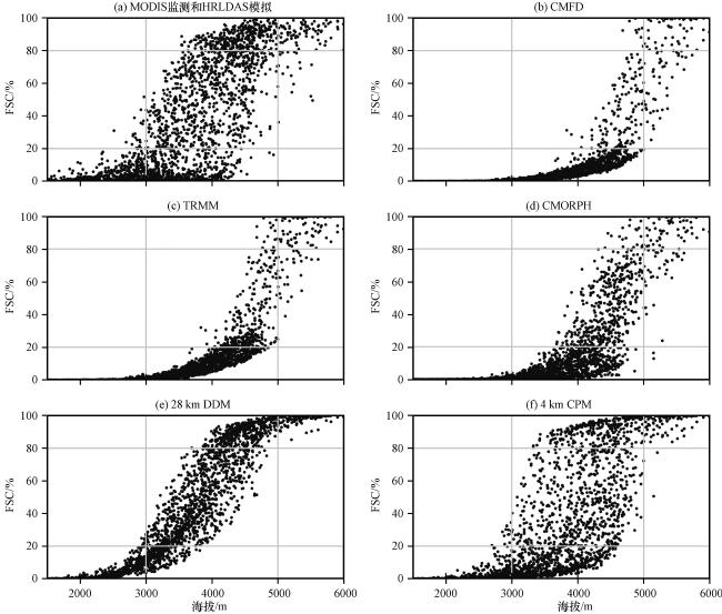
图3 2013年10月至2014年5月MODIS监测(a)和HRLDAS模拟的CMFD (b)、 TRMM (c)、 CMORPH (d)、 28 km DDM (e)和4 km CPM (f)积雪覆盖度随海拔变化的散点分布(来自Gao et al, 2020a

Fig.3

Scatterplots of the mean snow-cover fraction from October 2013 to May 2014 versus elevation from the MODIS (a) and HRLDAS simulations driven by precipitation from, respectively (From <a href="javascript:;" class="mag_content_a" onclick="piaofuRef(this,'R26')" rid="R26">Gao et al, 2020a</a>)
总之, 降水是地表环境对变暖响应模拟的关键因素, 而基于站点观测和遥感反演的降水数据在青藏高原都存在很大的问题。气候模式综合考虑了气候系统内各圈层的相互作用, 是气候变化研究的有力工具。基于区域气候模式的动力降尺度方法可以为复杂地形条件下的环境变化研究提供高时空分辨率的气象信息, 成为提高复杂地形区域降水数据准确性的有效途径。

4 研究展望

陆面为气候系统模式提供下边界条件, 下边界条件的准确性对区域天气/气候模拟有重要影响, 然而, 陆面过程的高分辨率模拟还存在一定误差, 尤其是在地形复杂区域。陆面过程模拟的不确定性主要来自三个方面: 模式物理过程、 地表特征参数和气象驱动数据。单点陆面过程模拟的误差来源主要局限在模式物理过程, 而全球或区域陆面过程模拟误差来源除了模式物理过程, 还有区域地表特征参数, 以及网格化驱动数据的不确定性。近期越来越多的研究表明, 降水数据的精度已经成为提升陆面过程区域模拟的瓶颈。
气象观测站点大多位于便于架设观测设备的平坦区域, 加之站点测量的误差以及不确定性, 基于站点观测的降水融合产品难以表现地形复杂地区的非均匀性。卫星遥感降水产品和全球气候模式结果对降水非均匀性的表现也非常有限。而目前的研究认为, 对流允许尺度的动力降尺度可能是改善复杂地形条件降水模拟效果的有效途径。
气候系统是圈层相互作用的有机载体, 动力降尺度为陆面过程模拟提供高分辨率降水数据的同时, 陆面过程模拟也为区域气候模式提供准确的下边界条件。改进陆面过程模式, 准确模拟地表物质、 能量、 动量和水分的非均匀分布, 为气候系统提供体现地表非均匀性的下垫面状态, 进而准确模拟区域水循环, 是陆面过程和区域气候模拟的最终目的。

高艳红, 刘伟, 曾礼, 2021. 陆面过程高分辨率模拟的不确定性[J].高原气象, 40(6): 1364-1376.

GAO Yanhong, LIU Wei, ZENG Li, 2021. Uncertainties in the Regional High-Resolution Land Surface Simulations[J].Plateau Meteorology, 40(6): 1364-1376.

AdamJ CLettenmaierD P2003.Adjustment of global gridded precipitation for systematic bias[J].Journal of Geophysical Research: Atmospheres, 108(D9) D94257, 1-15.DOI: 10.1029/2002jd002499.

AyersJFicklinD LStewartI Talet2016.Comparison of CMIP3 and CMIP5 projected hydrologic conditions over the Upper Colorado River Basin[J].International Journal of Climatology36(11): 3807-3818.DOI: 10.1002/joc.4594.

BroxtonP DZengX BDawsonN2016.Why do global reanalyses and land data assimilation products underestimate snow water equivalent?[J].Journal of Hydrometeorology17(11): 2743-2761.DOI: 10.1175/jhm-d-16-0056.1.

ChenA FChenD LAzorin-MolinaC2018.Assessing reliability of precipitation data over the Mekong River Basin: A comparison of ground-based, satellite, and reanalysis datasets[J].International Journal of Climatology38(11): 4314-4334.DOI: 10.1002/joc.5670.

ChenD LXuB QYaoT Dalet2015.Assessment of past, present and future environmental changes on the Tibetan Plateau[J].Chinese Science Bulletin60(32): 3025-3035.DOI: 10.1360/n972014-01370.

ChenFDudhiaJ2001.Coupling an advanced land surface-hydrology model with the Penn State-NCAR MM5 modeling system.Part I: Model implementation and sensitivity[J].Monthly Weather Review129(4): 569-585.DOI: 10.1175/1520-0493(2001)129<0569: Caalsh>2.0.Co; 2.

ChenFKusakaHBornsteinRalet2011.The integrated WRF/urban modelling system: development, evaluation, and applications to urban environmental problems[J].International Journal of Climatology31(2): 273-288.DOI: 10.1002/joc.2158.

ChenFManningK WLemoneM Aalet2007.Description and evaluation of the characteristics of the NCAR high-resolution land data assimilation system[J].Journal of Applied Meteorology and Climatology46(6): 694-713.DOI: 10.1175/jam2463.1.

ChenFManningK WYatesD Nalet2009.Development of high resolution land data assimilation system and its application to WRF[R].Boulder, CO: National Center for Atmospheric Research.

ChenFMitchellKSchaakeJalet1996.Modeling of land surface evaporation by four schemes and comparison with FIFE observations[J].Journal of Geophysical Research-Atmospheres101(D3): 7251-7268.DOI: 10.1029/95jd02165.

CuoLZhangY XPiaoS Lalet2016.Simulated annual changes in plant functional types and their responses to climate change on the northern Tibetan Plateau[J].Biogeosciences13(12): 3533-3548.DOI: 10.5194/bg-13-3533-2016.

DaiY JXinQ CWeiNalet2019.A global high-resolution data set of soil hydraulic and thermal properties for Land Surface Modeling[J].Journal of Advances in Modeling Earth Systems11(9): 2996-3023.DOI: 10.1029/2019ms001784.

DaiY JZengQ C1997.A Land Surface Model (IAP94) For clima studies part I: Formulation and validation in off-line experiments[J].Advances in Atmospheric Sciences14(4): 433-460.

DickinsonR EHenderson-SellersAKennedyP J1993.Biosphere-Atmosphere Transfer Scheme (BATS) version le as coupled to the NCAR community climate model.Technical note.[NCAR (National Center for Atmospheric Research)][R].

National Center for Atmospheric Research, Boulder, (United States)CO.Scientific Computing Div.PB-94-106150/XAB; NCAR/TN-387+STR United States NTIS GRA English.

DickinsonR EHenderson-SellersAKennedyP Jalet1986.Biosphere-Atmosphere Transfer Scheme (BATS) for the NCAR Community Climate Model[R].Colorado: Atmospheric Research Boulder.

DouvilleH2009.Relative contribution of soil moisture and snow mass to seasonal climate predictability: A pilot study[J].Climate Dynamics34(6): 797-818.DOI: 10.1007/s00382-008-0508-1.

EstoqueR CMurayamaYMyintS W2017.Effects of landscape composition and pattern on land surface temperature: An urban heat island study in the megacities of Southeast Asia[J].Science of the Total Environment, 577: 349-359.DOI: 10.1016/j.scitotenv.2016.10.195.

FanY XMaZ QMaY Malet2021.Respective advantages of “Top-Down” based GPM IMERG and “Bottom-Up” based SM2RAIN-ASCAT precipitation products over the Tibetan Plateau[J].Journal of Geophysical Research: Atmospheres126(7): 1-17.DOI: 10.1029/2020jd033946.

FangH2009.Document for Global Land Data Assimilation System (GLDAS) Products[R].Services and Application from NASA Hydrology Data and Information Services Center (HDISC).

GaoX JShiYZhangDalet2012a.Uncertainties in monsoon precipitation projections over China: Results from two high-resolution RCM simulations[J].Climate Research, 52: 213-226.DOI: 10.3354/cr01084.

GaoX JShiYZhangD Falet2012b.Climate change in China in the 21st century as simulated by a high resolution regional climate model[J].Chinese Science Bulletin57(10): 1188-1195.DOI: 10.1007/s11434-011-4935-8.

GaoX JXuYZhaoZ Calet2006.On the role of resolution and topography in the simulation of East Asia precipitation[J].Theoretical and Applied Climatology86(1/4): 173-185.DOI: 10. 1007/s00704-005-0214-4.

GaoY CLiuM F2013.Evaluation of high-resolution satellite precipitation products using rain gauge observations over the Tibetan Plateau[J].Hydrology and Earth System Sciences17(2): 837-849.DOI: 10.5194/hess-17-837-2013.

GaoY HChenD L2017.Modeling of Regional Climate over the Tibetan Plateau[C]//Oxford Research Encyclopedia of Climate Science.New York: Oxford University Press, 1-29.

GaoY HChenFBarlageMalet2008.Enhancement of land surface information and its impact on atmospheric modeling in the Heihe River Basin, northwest China[J].Journal of Geophysical Research-Atmospheres, 113(D20), 1-19.DOI: 10.1029/2008jd010359.

GaoY HChenFJiangY S2020a.Evaluation of a convection-permitting modeling of precipitation over the Tibetan Plateau and its influences on the simulation of snow-cover fraction[J].Journal of Hydrometeorology21(7): 1531-1548.DOI: 10.1175/jhm-d-19-0277.1.

GaoY HChenFLettenmaierD Palet2018.Does elevation-dependent warming hold true above 5000m elevation? Lessons from the Tibetan Plateau[J].Npj Climate and Atmospheric Science, 1: 1-7.DOI: 10.1038/s41612-018-0030-z.

GaoY HChenFMiguez-MachoGalet2020b.Understanding precipitation recycling over the Tibetan Plateau using tracer analysis with WRF[J].Climate Dynamics, 55: 1-17.DOI: 10.1007/s00382-020-05426-9.

GaoY HLeungL RZhangY Xalet2015b.Changes in moisture flux over the Tibetan Plateau during 1979-2011: Insights from a high-resolution simulation[J].Journal of Climate28(10): 4185-4197.DOI: 10.1175/jcli-d-14-00581.1.

GaoY HLiKChenFalet2015c.Assessing and improving Noah-MP land model simulations for the central Tibetan Plateau[J].Journal of Geophysical Research-Atmospheres120(18): 9258-9278.DOI: 10.1002/2015jd023404.

GaoY HLvS HChengG D2004.Simulation of rainfall and watershed convergence process in upper reaches of Heihe River Basin, July 2002[J].Science in Chin (Earth Sciences a)47(): 1-8.

GaoY HXiaoL HChenD Lalet2017.Quantification of the relative role of land-surface processes and large-scale forcing in dynamic downscaling over the Tibetan Plateau[J].Climate Dynamics48(5/6): 1705-1721.DOI: 10.1007/s00382-016-3168-6.

GaoY HXuJ WChenD L2015a.Evaluation of WRF mesoscale climate simulations over the Tibetan Plateau during 1979-2011[J].Journal of Climate28(7): 2823-2841.DOI: 10.1175/jcli-d-14-00300.1.

GiorgiFBatesG TNiemanS J1992.Simulation of the arid climate of the Southern Great-Basin using a regional climate model[J].Bulletin of the American Meteorological Society73(11): 1807-1822.DOI: 10.1175/1520-0477(1992)073<1807: Sotaco>2.0.Co; 2.

GoodisonB ELouieP YYangD Q1998.WMO solid precipitation measurement intercomparison[R].WMO: Instruments and Observing Methods Report No.67.

GuH PJinJ MWuY Halet2013.Calibration and validation of lake surface temperature simulations with the coupled WRF-lake model[J].Climatic Change129(3/4): 471-483.DOI: 10.1007/s10584-013-0978-y.

GuoZ CDirmeyerP AHuZ Zalet2006.Evaluation of the Second Global Soil Wetness Project soil moisture simulations: 2.Sensitivity to external meteorological forcing[J].Journal of Geophysical Research, 111(D22), 1-11.DOI: 10.1029/2006jd007845.

HallD KRiggsG ASalomonsonV V1995.Development of methods for mapping global snow cover using moderate resolution imaging spectroradiometer data[J].Remote Sensing of Environment54(2): 127-140.

HuZ YZhouQ MChenXalet2018.Evaluation of three global gridded precipitation data sets in central Asia based on rain gauge observations[J].International Journal of Climatology38(9): 3475-3493.DOI: 10.1002/joc.5510.

HuangA N, Lazhu, WangJ Balet2019.Evaluating and Improving the Performance of Three 1-D Lake Models in a Large Deep Lake of the Central Tibetan Plateau[J].Journal of Geophysical Research-Atmospheres124(6): 3143-3167.DOI: 10.1029/2018jd029610.

ImmerzeelW WPetersenLRagettliSalet2014.The importance of observed gradients of air temperature and precipitation for modeling runoff from a glacierized watershed in the Nepalese Himalayas[J].Water Resources Research50(3): 2212-2226.DOI: 10.1002/2013wr014506.

ImmerzeelW WWandersNLutzA Falet2015.Reconciling high altitude precipitation in the upper Indus Basin with glacier mass balances and runoff[J].Hydrology and Earth System Sciences Discussions12(5): 4755-4784.DOI: 10.5194/hessd-12-4755-2015.

IPCC, 2007.Climate Change 2007-The Physical Science Basis Contribution of Working Group I to the Fourth Assessment Report of the IPCC[R].32 Avenue of the Americas, New York, NY 10013-2473, USA: Cambridge University Press.

JiJ J1995.A climate-vegetation interaction model: Simulating physical and biological processes at the surface[J].Journal of Biogeography22(2/3): 445-451.

JiJ JHuY C1989.A simple land surface processes model for use in climate study[J].Acta Meteorologica Sinica3(3): 342-351.

JiZ MKangS C2013.Double-nested dynamical downscaling experiments over the Tibetan Plateau and their projection of climate change under two RCP scenarios[J].Journal of the Atmospheric Sciences70(4): 1278-1290.DOI: 10.1175/jas-d-12-0155.1.

JiangY SChenFGaoY Halet2019.Using Multisource Satellite Data to Assess Recent Snow-Cover Variability and Uncertainty in the Qinghai-Tibet Plateau[J].Journal of Hydrometeorology20(7): 1293-1306.DOI: 10.1175/jhm-d-18-0220.1.

JiangY SChenFGaoY Halet2020.Assessment of Uncertainty Sources in Snow Cover Simulation in the Tibetan Plateau[J].Journal of Geophysical Research: Atmospheres125(18), 1-17.DOI: 10.1029/2020jd032674.

Lawrence D, Fisher R, Koven C, et al, 2020.Technical description of version 5.0 of the Community Land Model (CLM)[Z].Boulder, Colorado: National Center for Atmospheric Research (NCAR).

LetcherT WMinderJ R2015.Characterization of the simulated regional snow albedo feedback using a regional climate model over complex terrain[J].Journal of Climate28(19): 7576-7595.DOI: 10.1175/jcli-d-15-0166.1.

LeungL RKuoY HTribbiaJ2006.Research needs and directions of regional climate modeling using WRF and CCSM[J].Bulletin of the American Meteorological Society87(12): 1747-1752.DOI: 10.1175/bams-87-12-1747.

LiH DZhouY YWangXalet2019.Quantifying urban heat island intensity and its physical mechanism using WRF/UCM[J].Science of the Total Environment, 650: 3110-3119.DOI: 10. 1016/j.scitotenv.2018.10.025.

LiXChengG DLinHalet2018.Watershed system model: The essentials to model complex human-nature system at the river basin scale[J].Journal of Geophysical Research: Atmospheres123(6): 3019-3034.DOI: 10.1002/2017jd028154.

LiuS HHuYHuFalet2005.Numerical simulation of land-atmosphere interaction and oasis effect over oasis-desert[J].Chinese Journal of Geophysics48(5): 1019-1027.

LiuXChenFBarlageMalet2016.Noah-MP-Crop: Introducing dynamic crop growth in the Noah-MP land surface model[J].Journal of Geophysical Research: Atmospheres121(23): 13953-13972.DOI: 10.1002/2016jd025597.

MaY ZTangG QLongDalet2016.Similarity and error intercomparison of the GPM and its predecessor-TRMM multisatellite precipitation analysis using the best available hourly gauge network over the Tibetan Plateau[J].Remote Sensing8(7), 1-17.DOI: 10.3390/rs8070569.

MaZ QXuJ TZhuS Yalet2020.AIMERG: a new Asian precipitation dataset (0.1°/half-hourly, 2000-2015) by calibrating the GPM-era IMERG at a daily scale using APHRODITE[J].Earth System Science Data12(3): 1525-1544.DOI: 10.5194/essd-12-1525-2020.

MargulisS AMclaughlinDEntekhabiDalet2002.Land data assimilation and estimation of soil moisture using measurements from the Southern Great Plains 1997 Field Experiment[J].Water Resources Research38(12): 1-18.DOI: 10.1029/2001wr001114.

MaussionFSchererDMölgTalet2014.Precipitation seasonality and variability over the Tibetan Plateau as resolved by the high Asia reanalysis[J].Journal of Climate27(5): 1910-1927.DOI: 10.1175/jcli-d-13-00282.1.

MearnsLTeamN2009.The North American Regional Climate Change Assessment Program (NARCCAP): Overview of Phase II results[J].IOP Conference Series: Earth and Environmental Science6(2), 1-1.DOI: 10.1088/1755-1307/6/2/022007.

MiddelAHaebKBrazelA Jalet2014.Impact of urban form and design on mid-afternoon microclimate in Phoenix Local Climate Zones[J].Landscape and Urban Planning, 122: 16-28.DOI: 10.1016/j.landurbplan.2013.11.004.

MitchellK E2004.The multi-institution North American Land Data Assimilation System (NLDAS): Utilizing multiple GCIP products and partners in a continental distributed hydrological modeling system[J].Journal of Geophysical Research, 109(D7), 1-32.DOI: 10.1029/2003jd003823.

NunesE LCostaM HMalhadoA C Malet2012.Monitoring carbon assimilation in South America's tropical forests: Model specification and application to the Amazonian droughts of 2005 and 2010[J].Remote Sensing of Environment, 117: 449-463.DOI: 10.1016/j.rse.2011.10.022.

OlesonK WDaiYBonanGalet2004, Technical description of the Community Land Model (CLM)[DB/OL].Boulder, Colorado: National Center For Atmospheric Research.NCAR/TN_461+STR, NCAR TECHNICAL NOTE.[2021-04-10].

OlesonK WLawrenceD MBonanG Balet2013, Technical Description of version 4.5 of the Community Land Model (CLM)[DB/OL].NCAR/TN-503+STR NCAR Technical Note.[2021-04-10].

OnolBBozkurtDTuruncogluU Ualet2014.Evaluation of the twenty-first century RCM simulations driven by multiple GCMs over the Eastern Mediterranean-Black Sea region[J].Climate Dynamics42(7/8): 1949-1965.DOI: 10.1007/s00382-013-1966-7.

PanY JLyuS HLiS Salet2017.Simulating the role of gravel in freeze-thaw process on the Qinghai-Tibet Plateau[J].Theoretical and Applied Climatology127(3/4): 1011-1022.DOI: 10.1007/s00704-015-1684-7.

PepinNBradleyR SDiazH Falet2015.Elevation-dependent warming in mountain regions of the world[J].Nature Climate Change5(5): 424-430.DOI: 10.1038/nclimate2563.

PicklerCMölgT2021.General Circulation Model Selection Technique for Downscaling: Exemplary Application to East Africa[J].Journal of Geophysical Research: Atmospheres126(6), 1-28.DOI: 10.1029/2020jd033033.

PreinA FHollandG JRasmussenR Malet2013.Importance of Regional Climate Model Grid Spacing for the Simulation of Heavy Precipitation in the Colorado Headwaters[J].Journal of Climate26(13): 4848-4857.DOI: 10.1175/jcli-d-12-00727.1.

PreinA FLanghansWFosserGalet2015.A review on regional convection-permitting climate modeling: Demonstrations, prospects, and challenges[J].Reviews of Geophysics53(2): 323-361.DOI: 10.1002/2014RG000475.

RasmussenRLiuCIkedaKalet2011.High-Resolution Coupled Climate Runoff Simulations of Seasonal Snowfall over Colorado: A Process Study of Current and Warmer Climate[J].Journal of Climate24(12): 3015-3048.DOI: 10.1175/2010jcli3985.1.

RoySByrneJPickeringC2012.A systematic quantitative review of urban tree benefits, costs, and assessment methods across cities in different climatic zones[J].Urban Forestry & Urban Greening11(4): 351-363.DOI: 10.1016/j.ufug.2012.06.006.

Ruiz-BarradasANigamS2006.IPCC’s twentieth-century climate simulations: Varied representations of North American hydroclimate variability[J].Journal of Climate19(16): 4041-4058.

SanjayJKrishnanRShresthaA Balet2017.Downscaled climate change projections for the Hindu Kush Himalayan region using CORDEX South Asia regional climate models[J].Advances in Climate Change Research8(3): 185-198.DOI: 10.1016/j.accre.2017.08.003.

ScholesR J2016.Climate change and ecosystem services[J].Wiley Interdisciplinary Reviews: Climate Change7(4): 537-550.DOI: 10.1002/wcc.404.

SellersP JMintzYSudY Calet1986.A Simple Biosphere Model (SIB) for Use within General Circulation Models[J].Journal of Atmospheric Sciences43(6): 505-531.

SellersP JRandallD ACollatzG Jalet1996.A revised land surface parameterization (SiB2) for atmospheric GCMS.Part I: Model formulation[J].Journal of Climate9(4): 676-705.DOI: 10.1175/1520-0442(1996)009<0676: Arlspf>2.0.Co; 2.

ShangguanWDaiYDuanQalet2014.A global soil data set for earth system modeling[J].Journal of Advances in Modeling Earth Systems6(1): 249-263.DOI: 10.1002/2013ms000293.

Shashua-BarLPearlmutterDErellE2009.The cooling efficiency of urban landscape strategies in a hot dry climate[J].Landscape and Urban Planning92(3/4): 179-186.DOI: 10.1016/j.landurbplan.2009.04.005.

StovinVVesuvianoGKasminH2012.The hydrological performance of a green roof test bed under UK climatic conditions[J].Journal of Hydrology, 414: 148-161.DOI: 10.1016/j.jhydrol. 2011.10.022.

SuF GDuanX LChenD Lalet2013.Evaluation of the global climate models in the CMIP5 over the Tibetan Plateau[J].Journal of Climate26(10): 3187-3208.DOI: 10.1175/jcli-d-12-00321.1.

SunZJiaS FLvA Falet2015.Assesment on precision of temperature simulated by the IPCC AR5 GCMs in China, 1996-2005[J].Progress in Geography, 34(10): 1229-1240.

SwensonS CLawrenceD M2012.A new fractional snow-covered area parameterization for the Community Land Model and its effect on the surface energy balance[J].Journal of Geophysical Research: Atmospheres, 117(D21), 1-20.DOI: 10.1029/2012jd018178.

TongKSuF GYangD Qalet2014.Tibetan Plateau precipitation as depicted by gauge observations, reanalyses and satellite retrievals[J].International Journal of Climatology34(2): 265-285.DOI: 10.1002/joc.3682.

VionnetVSixDAugerLalet2019.Sub-kilometer precipitation datasets for snowpack and glacier modeling in alpine terrain[J].Frontiers in Earth Science, 7: 1-21.DOI: 10.3389/feart.2019. 00182.

WangA HZengX B2011.Sensitivities of terrestrial water cycle simulations to the variations of precipitation and air temperature in China[J].Journal of Geophysical Research, 116(D2), 1-11.DOI: 10.1029/2010jd014659.

WangLLiX PChenY Yalet2016.Validation of the global land data assimilation system based on measurements of soil temperature profiles[J].Agricultural and Forest Meteorology218-219: 288-297.DOI: 10.1016/j.agrformet.2016.01.003.

WangX YMiaoS GLiuH Nalet2019.Assessing the impact of urban hydrological processes on the summertime urban climate in Nanjing using the WRF model[J].Journal of Geophysical Research-Atmospheres124(23): 12683-12707.DOI: 10.1029/2019jd030674.

WeiS GDaiY JDuanQ Yalet2014.A global soil data set for earth system modeling[J].Journal of Advances in Modeling Earth Systems6(1): 249-263.DOI: 10.1002/2013ms000293.

WenL JLvS HLiZ Galet2015a.Impacts of the two biggest lakes on local temperature and precipitation in the Yellow River Source Region of the Tibetan Plateau[J].Advances in Meteorology, 2015: 1-10.DOI: 10.1155/2015/248031.

WenL JLyuS HKirillinGalet2016.Air-lake boundary layer and performance of a simple lake parameterization scheme over the Tibetan highlands[J].Tellus A: Dynamic Meteorology and Oceanography68(1), 1-15.DOI: 10.3402/tellusa.v68.31091.

WenL JNagabhatlaNZhaoLalet2015b.Impacts of salinity parameterizations on temperature simulation over and in a hypersaline lake[J].Chinese Journal of Oceanology and Limnology33(3): 790-801.

WuLZhaiP M2013.Validation of daily precipitation from two high-resolution satellite precipitation datasets over the Tibetan Plateau and the regions to its east[J].Acta Meteorologica Sinica26(6): 735-745.DOI: 10.1007/s13351-012-0605-2.

XiaoZ XDuanA M2016.Impacts of Tibetan Plateau snow cover on the interannual variability of the East Asian summer monsoon[J].Journal of Climate29(23): 8495-8514.DOI: 10.1175/jcli-d-16-0029.1.

XueYHouserP RMaggioniValet2021.Evaluation of high mountain Asia-land data assimilation system (Version 1) from 2003 to 2016, Part I: A hyper-resolution terrestrial modeling system[J].Journal of Geophysical Research: Atmospheres126(8), 1-32.DOI: 10.1029/2020jd034131.

XueY KZengF JSchlosserC A1996.SSiB and its sensitivity to soil properties-A case study using HAPEX-Mobilhy data[J].Global and Planetary Change13(1/4): 183-194.DOI: 10. 1016/0921-8181(95)00045-3.

YangD QKaneDZhangZ Palet2005.Bias corrections of long-term (1973-2004) daily precipitation data over the northern regions[J].Geophysical Research Letters32(19): 1-5.DOI: 10.1029/2005gl024057.

YangK2005.Inverse analysis of the role of soil vertical heterogeneity in controlling surface soil state and energy partition[J].Journal of Geophysical Research, 110(D8).DOI: 10.1029/2004jd005500.

YangKChenY YQinJ2009.Some practical notes on the land surface modeling in the Tibetan Plateau[J].Hydrology and Earth System Sciences13(5): 687-701.

YangKQinJGuoX Falet2009.Method Development for Estimating Sensible Heat Flux over the Tibetan Plateau from CMA Data[J].Journal of Applied Meteorology and Climatology48(12): 2474-2486.DOI: 10.1175/2009jamc2167.1.

YangM XWangS LYaoT Dalet2004.Desertification and its relationship with permafrost degradation in Qinghai-Xizang (Tibet) plateau[J].Cold Regions Science and Technology39(1): 47-53.DOI: 10.1016/j.coldregions.2004.01.002.

YangXWoodE FSheffieldJalet2018.Bias Correction of Historical and Future Simulations of Precipitation and Temperature for China from CMIP5 Models[J].Journal of Hydrometeorology19(3): 609-623.DOI: 10.1175/jhm-d-17-0180.1.

YangYChenR SSongY X2014.An Overview of Measurement and Calculation Methods on the Land Surface Temperature on Alpine Mountainous Cold Regions[J].Advance in Earth Sciences29(12): 1383-1393.

YangZ LDickinsonR ERobockAalet1997.Validation of the Snow Submodel of the Biosphere-Atmosphere Transfer Scheme with Russian Snow Cover and Meteorological Observational Data[J].Journal of Climate, 10: 353-373.

YeB SYangD QDingY Jalet2004.A bias-corrected precipitation climatology for China[J].Journal of Hydrometeorology5(6): 1147-1160.

YoonYKumarS VFormanB Aalet2019.Evaluating the Uncertainty of Terrestrial Water Budget Components Over High Mountain Asia[J].Frontiers in Earth Science, 7: 21, 1-21.DOI: 10. 3389/feart.2019.00120.

ZengY NFengZ DCaoG C2003.Grassland desertification and its impacts on carbon cycle in the source region of the Yellow River, northeastern Qinghai-Tibetan Plateau by remote sensing[C]//IGARSS 2003.2003 IEEE International Geoscience and Remote Sensing Symposium.Proceedings (IEEE Cat.No.03CH37477.

IEEE, 2003: 2644-2646.

ZhangGChenFGanY J2016.Assessing uncertainties in the Noah-MP ensemble simulations of a cropland site during the Tibet Joint International Cooperation program field campaign[J].Journal of Geophysical Research-Atmospheres121(16): 9576-9596.DOI: 10.1002/2016jd024928.

ZhangZBarlageMChenFalet2020.Joint modeling of crop and irrigation in the central United States using the Noah-MP Land Surface Model[J].Journal of Advances in Modeling Earth Systems12(7), 1-19.DOI: 10.1029/2020ms002159.

ZhangZ HWangW ZMaM Galet2010.Data processing and product analysis of eddy covariance flux data for WATER[J].Remote Sensing Technology and Application25(6): 788-796.

ZhaoLLiY NXuS Xalet2006.Diurnal, seasonal and annual variation in net ecosystem CO2 exchange of an alpine shrubland on Qinghai--Tibetan plateau[J].Global Change Biology12(10): 1940-1953.DOI: 10.1111/j.1365-2486.2006.01197.x.

ZhengD HVan Der VeldeRSuZ Balet2017.Evaluation of Noah Frozen Soil Parameterization for Application to a Tibetan Meadow Ecosystem[J].Journal of Hydrometeorology18(6): 1749-1763.DOI: 10.1175/jhm-d-16-0199.1.

ZhongZLuWSongSalet2011.A new scheme for effective roughness length and effective zero-plane displacement in land surface models[J].Journal of Hydrometeorology12(6): 1610-1620.DOI: 10.1175/2011jhm1375.1.

ZhouF HZhangR WShiRalet2017.A study of data processing and quality assessment of the eddy convariance system off Yongxing Island[J].Journal of Tropical Oceanography36(4): 48-59.

ZhouXBeljaarsAWangYalet2017.Evaluation of WRF Simulations With Different Selections of Subgrid Orographic Drag Over the Tibetan Plateau[J].Journal of Geophysical Research: Atmospheres122(18): 9759-9772.DOI: 10.1002/2017jd027212.

戴永久, 2020.陆面过程模式研发中的问题[J].大气科学学报43(1): 33-38.DOI: 10.13878/j.cnki.dqkxxb.20200103006.

符淙斌, 马柱国, 2008.全球变化与区域干旱化[J].大气科学32(4): 752-760.

高艳红, 程国栋, 崔文瑞, 2006.陆面水文过程与大气模式的耦合及其在黑河流域的应用[J].地球科学进展21(12): 1283-1292.

高艳红, 伟 刘, 李海英, 等, 2007.黑河流域土壤质地分类数据建立及其模拟效果检验[J].高原气象26(5): 967-974.

李文耀, 魏楠, 黄丽娜, 等, 2020.土壤数据集对全球陆面过程模拟的影响[J].气候与环境研究25(5): 555-574.DOI: 10.3878/j.issn.1006-9585.2020.20025.

刘伟, 高艳红, 李海英, 等, 2007.黑河流域土地覆盖分类数据的建立及其影响的模拟[J].高原气象26(2): 278-285.

水利部黄河水利委员国际合作与科技局, 2008.黄河流域气候变化影响及水资源评估报告[R/OL].郑州: 水利部黄河水利委员会国际合作与科技局.[2020-12-25].

吴龙刚, 王爱慧, 盛炎平, 2014.土壤质地对中国区域陆面过程模拟的影响[J].气候与环境研究19(5): 559-571.DOI: 10. 3878/j.issn.1006-9585.2013.13055.

武洁, 高艳红, 潘永洁, 等, 2020.青藏高原中东部地区土壤湿度模拟性能评估以及误差分析[J].地球物理学报63(6): 2184-2198.

姚檀栋, 冯仁国, 陈德亮, 2015.西藏高原环境变化科学评估[R].北京: 中国科学院.

朱连奇, 许立民, 2011.全球变化对陆地生态系统的影响研究[J].地域研究与开发30(2): 161-164.

Outlines

/