
Close×
2026, Vol.45 No.3
Founded in 1982
bimonthly
CN 62-1061/P
ISSN 1000-0534
Sponsored by: Northwest Institute of ecological environment and resources, Chinese Academy of Sciences
Governed by: Chinese Academy of Sciences
Editor-in-chief: Wen Jun
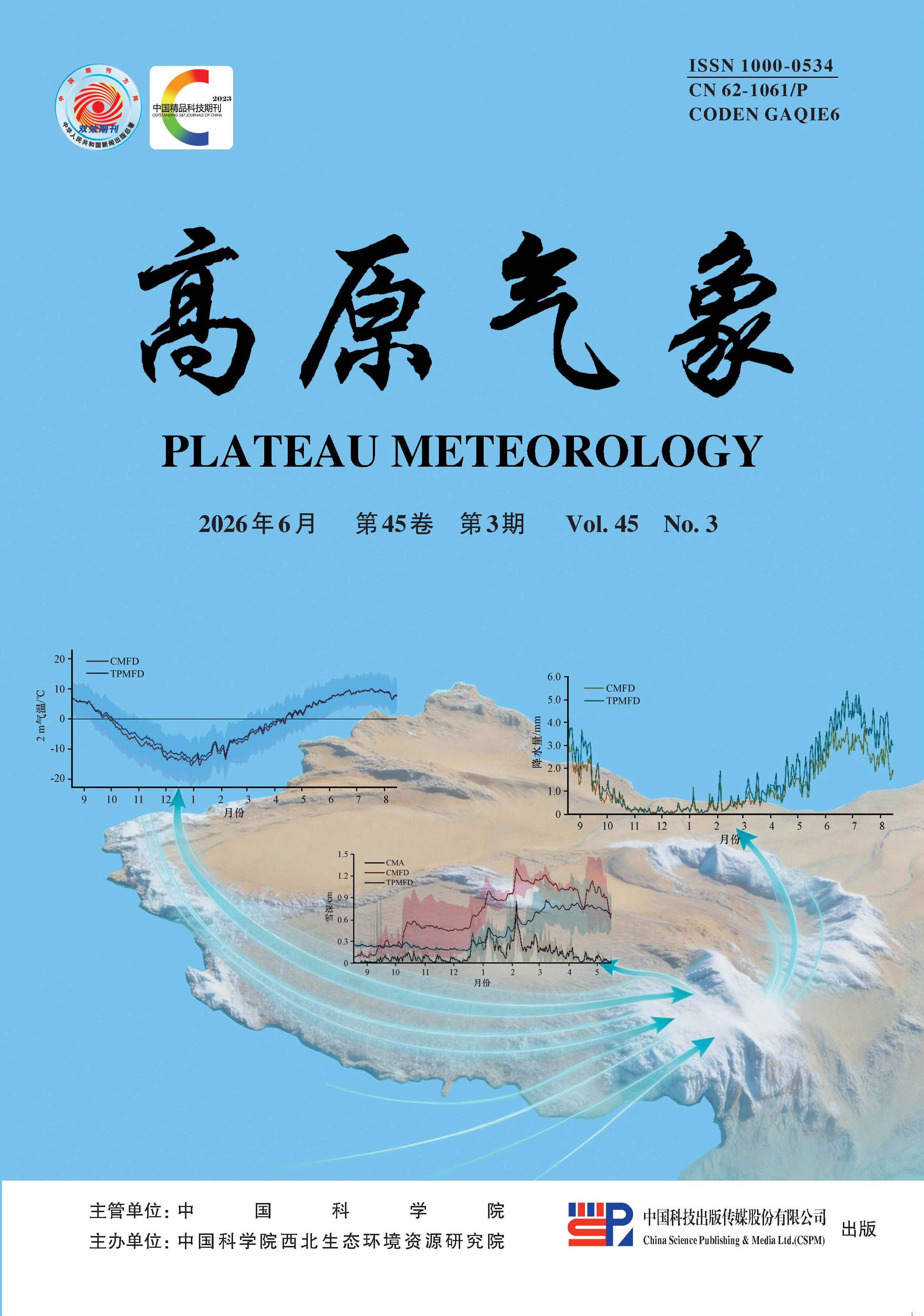
Snow cover is an important component of the Qinghai-Xizang Plateau (QXP) cryosphere, exerting a significant impact on regional and downstream weather and climate through radiative and hydrological processes.However, the simulation of snow cover on the QXP remains systematically biased.Previous studies have focused more on the impact of snow cover parameterization schemes, while giving less attention to the role of meteorological forcing data.In this study, we compare the China meteorological forcing dataset (CMFD) and the high-resolution near-surface meteorological forcing dataset for the Third Pole region (TPMFD), and simulate the snow cover variations on the QXP during snow seasons in the hydrological years of 2010 -2015 by driving the land surface model SSiB3-SNICAR.The results show that TPMFD substantially improves snow simulation accuracy.The root mean square error (RMSE) of the simulated snow depth is reduced from 0.64 cm to 0.21 cm in winter, and the RMSE of the simulated snow cover fraction is reduced from 6.20% to 4.15%.For snow phenology, the TPMFD experiment simulates a longer snow cover duration in both thick and thin snow regions.TPMFD also enhances the simulation performance of surface energy balance in winter, and the RMSE of simulated surface albedo and land surface temperature is reduced to 0.15 and 3.13 ℃.TPMFD markedly improves simulation accuracy over the western and southeastern QXP by refining precipitation and air temperature inputs, notably through increased winter precipitation below 0 ℃.This enhancement reduces both the negative bias in the east and the positive bias in the western TP.Although the complex topography and snow parameterization schemes contribute to simulation uncertainties, this study still provides an effective reference for the improvement of snow cover simulation on the QXP.
The low-pressure weather systems on the Qinghai-Xizang Plateau not only influence the cloud-precipitation over the main body of the Qinghai-Xizang Plateau, but also play a crucial role in the generation and development of disastrous weather such as rainstorms in the eastern regions of China.This paper makes use of the data from the ground-based Ka-band millimeter-wave cloud radar (Ka-CR), K-band micro-rain radar (K-MRR) and Parsivel2 laser disdrometer in Nagqu during the Third Qinghai-Xizang Plateau Experiment of Atmospheric Sciences (TIPEX-III) from July to August 2014 and July to August 2015.Combining with the Yearbook of Plateau Vortices and Shear Lines, the ERA-5 atmospheric reanalysis data, and the sounding data from Nagqu Station, First, the observational data of the three devices are processed and subjected to quality control.Subsequently, a comparative study is carried out on the macro-micro characteristics of cloud-precipitation in Nagqu under the influence of plateau vortices and shear lines, as well as their differences.Additionally, the atmospheric environmental conditions corresponding to the differences in cloud-precipitation structures and physical characteristics are discussed.The results show that: (1) Single-layer clouds dominate over Nagqu, but under the influence of low vortices, a higher proportion of double and multi-layer clouds are formed.The low vortices produce more and deeper convective or high clouds, corresponding to overall higher cloud bases and tops and thicker cloud layers compared to the shear line.In contrast, the overall cloud body of the shear line is relatively thin or there are more middle and low clouds.In terms of precipitation, the proportion of moderate-intensity precipitation under the low vortex is small, but the proportions of weak and strong precipitation are larger.(2) The bright band feature of the low vortex radar echo is more prominent.The probability distributions of the reflectivity factor (Z) and radial velocity (Vr ) of the low vortex are more concentrated compared to the shear line.The echoes in the high-frequency region are weaker, but there are also some stronger echoes.The quantile profiles of Vr and spectrum width (W) decrease and increase as the height decreases, reflecting the continuous coalescence and riming growth processes during the ice particle sedimentation.(3) The concentrations of raindrops of all particle sizes formed by ice particles in the low vortex when they just melted (at an altitude of about 0.9 km above the ground) are higher than those of the shear line.From 0.7 km to the ground, the number concentrations of large raindrops in the low vortex are still higher, while the number concentrations of small raindrops are lower.At the same height, the raindrop spectra under the low vortex are wider than those of the shear line.As height decreases, raindrop collision and coalescence is the primary microphysical process for both weather types, but low vortices exhibit higher efficiency in raindrop collision and coalescence.(4) Comparing the atmospheric environmental conditions, it is found that the atmospheric temperature under the influence of the low vortex is slightly higher than that under the shear line, the relative humidity is significantly higher, and the convective available potential energy is also greater.The differences in thermodynamic and dynamic conditions under the control of these two types of weather align with the aforementioned differences in macro-micro parameters of cloud-precipitation.The research results reveal the macro-micro characteristics differences of cloud-precipitation in Nagqu under the influence of the plateau vortex and shear line, providing a reference basis for the early warning and forecasting of disastrous weather on the plateau.
In order to explore the response of snow cover to climate conditions under the complex topography, based on composite snow cover products on eight days of MOD10A2, daily temperature and precipitation from September 2001 to August 2020 and digital elevation model (DEM) in the Yellow-River source region, the snow cover frequency and percentage was used as an index to study the spatio-temporal variation characteristic of snow cover and their relations with major meteorological elements.The results are as follows: (1) Snow was mainly appeared from October to next May in the Yellow-River resource region, and the higher altitude, the greater snow cover percentage and the longer duration.Snow mainly distributed in high mountainous areas.The yearly accumulative process of snow showed a U-shaped at the altitude of 3500 m and below, the peak appeared in winter, while that transited to inverted W-shaped above the altitude of 3500 m, and the gap between two peaks gradually reduced with the rising of altitude, the appearing time of the maximum peak shifted from spring to autumn.(2) The snow cover percentages on the northern and northerly slopes were more than that on the southern and southerly slopes during the accumulative period, among the maximum was on the northeastern slope, and the minimum was on the southern slope, but the yearly variation characteristics with inverted W-shaped were similar and synchronous on each slope, the maximum and secondary peaks appeared at the end of October and the early of April, respectively.(3) Under the background of warming and humidification, the snow cover percentage during the accumulative period exhibited an overall increasing trend with a rate of about 5.6% per 10-year in the Yellow-River resource since 2001, especially at heights above 4000 m.The significant increase of snow cover area in spring and winter at heights 4000~5000 m contributed greatly to the increase of snow cover percentage during the accumulative period.(4) The average snow cover percentage first increased and then decreased with the decline of temperature and the increase of precipitation during the cumulative period in each altitude zone of the Yellow-River source, and the higher the altitude, the higher the fitting goodness between the two.The consistent increase of precipitation was the key factor contributing to the increase of snow cover percentage in each season of accumulative period since 2001, especially the significant increase of precipitation at high altitude areas in spring.Snow was more dependent on precipitation at high altitude areas.
Under the ongoing warming and humidification trend on the Qinghai-Xizang Plateau, the influence of rainfall on the hydrothermal conditions of frozen soil has become increasingly significant.To investigate the effects of rainfall characteristics on the hydrothermal state of seasonally frozen soil, this study analyzed the responses of frozen soil hydrothermal conditions under varying rainfall regimes based on continuous in-situ monitoring of meteorological variables and soil hydrothermal dynamics in Riwoqê County.The results indicate that the study area is dominated by short-duration (0 h˂H≤6 h) and small-amount (0.1 mm≤P≤9.9 mm) events, accounting for 57.81% and 84.39% of the total, respectively.Under similar rainfall amounts (7.6 mm≤P≤8.1 mm), short-duration events during the thawing period accelerates cooling of the 0~15 cm soil layer (by 11.13%~81.49%) and reduces heating of the 25~35 cm layer (by 18.18%~85.07%), while longer events primarily mitigate temperature changes.Short-duration rainfall also produces the largest increase in soil moisture (average 6.90% at 5~35 cm), though the rates of increase and decrease generally decline with rainfall duration.Under comparable durations (10 h≤H≤13 h), heavy rainfall induces rapid cooling in the 0~25 cm soil layer and slight warming at 35~45 cm (1.0 ℃ and 0.8 ℃, respectively), whereas lighter rainfall mainly weakens temperature variation.Small, short-duration events (H≤5 h, P≤5 mm) slowed temperature change with minimal effects below 15 cm, and soil moisture exhibits greatest increases during the complete thawing period (0.59% at 2.5~15 cm) while smallest during complete freezing period.Overall, rainfall typically had a cooling effect, as theoretical rainwater temperatures were consistently lower than surface soil temperatures (hourly temperature difference was -1.57~30.99 ℃, daily average temperature difference was 0.45~15.86 ℃), particularly from June to August.
Soil moisture is the key variable of the land-atmosphere interactions and ecosystem dynamics, so obtaining the soil moisture data with high spatiotemporal resolution is significant for simulating the hydrological process and managing the resource.The study is Maqu County,which is located on the eastern edge of the Qinghai-Tibet Plateau.We choose the SMAP daily soil moisture products and hourly in situ observations from ISMN as the base data.we build a Bi-LSTM model by using the GEE technology to construct the data in temporal scale, and by utilizing the random forest regression to downscale the soil moisture from 9 km to 250 m with the multi-high-resolution data (NDVl, DEM, and LST).The results show that Bi-LSTM model with a ratio constrained correction can estimate the hourly soil moisture effectively, have a well performance in multi-site validation with a maximum R 2 of 0.8735, and the random forest model give us a distribution characterization with more refined spatial scale.In this study, we refine the remotely sensed soil moisture in space-time dimension synchronously, and overcome the limitations of traditional approaches which build model by downscaling spatial scale only.
On March 27, 2024, a disastrous gust damaged the terminal building at Kunming Changshui International Airport in Yunnan, China.The role of coupled atmospheric gravity waves in this event is examined using conventional surface meteorological observations, high-resolution mesoscale surface network, upper-air sounding data, ERA5 reanalysis data and FY-2G geostationary satellite imagery.The results show that: (1) After solar heating in the morning, an atmospheric gravity wave originating over the Hengduan Mountains propagated southeastward under the influence of westerly flow.Meanwhile, another gravity wave generated over the Ailao Mountains propagated northeastward.These two gravity waves met near 100.56°E, 25°N about 09:53(Beijing Time), producing a significant coupling effect.(2) Based on the force analysis within a statically stable atmospheric layer and the initial perturbations induced by orographic lifting of the background flow, the analytical mathematics formula of the gravity wave was derived.Using satellite observations and infrared cloud imagery, the key parameters of each gravity waves including significant amplitude, wavelength, intrinsic frequency, and phase speed-were quantitatively obtained.(3) By harmonic analysis, the coupled wave with its zonal and meridional components were determined.The coupled wave induced substantial vertical motions above the airport: the zonal component generated a downward motion of 18 m·s-1, contributing positively to the surface winds, while the meridional component produced a weaker upward motion of 1 m·s-1, exerting a negative contribution.(4) The comprehensive effect of the coupled gravity waves and the DCAPE releasing generated a strong subsiding airflow, which enhanced the downward transport of upper-level jet momentum.This momentum transition was combined with the near-surface horizontal wind field, ultimately resulting in a catastrophic surface gust reaching 86.5 m·s-1, causing severe structural damage to the main terminal building of Kunming Airport.Quantitative assessment indicates that gravity waves contributed approximately 19.65% to the total wind speed.In contrast, the presence of either gravity wave A or B alone without coupling effect would account for a maximum wind speed contribution of only about 10 m·s-1.The role of gravity wave coupling is of critical in intensifying subsidence and promoting the extreme low-level wind hazards.
The frequent occurrence of heavy precipitation events poses severe challenges to urban disaster prevention and mitigation. High-resolution quantitative precipitation estimation (QPE) products are of great importance for monitoring intense rainfall processes, while X-band phased array radars (X-PAR), delivering detection data with high spatiotemporal resolution, provide a robust foundation for advanced QPE research. Due to the limitations of traditional radar-based QPE methods, such as insufficient nonlinear mapping capabilities and the lack of dynamic adaptive learning mechanisms, a minute-scale rainfall QPE method based on the CBAM U-Net model is proposed. This model enhances the learning capability for key precipitation regions and feature channels by incorporating the Channel and Spatial Attention Module (CBAM) and optimizes the temporal alignment between radar and ground rain gauge observations by introducing a temporal dimension to the model input. X-PAR data from four radars in Chengdu’s plain area during July-September 2023 -2024 were used to construct training and testing datasets. Additionally, the training process was optimized through the integration of learning rate warm-up and cosine annealing strategies, which accelerated the convergence speed and improved the model’s robustness. Evaluation metrics, including regression indices (CC, R MSE, R MAE, R MB) and classification metrics (POD, FAR, CSI), were applied to compare the performance of the CBAM U-Net against Attention U-Net, U-Net, and two Z-R methods. Results show that deep learning models significantly outperform traditional Z-R methods in both error metrics and stability. Among the three models, CBAM U-Net achieves the best performance (CC=0.665, R MSE=0.331 mm·min-1, R MAE=44.651%, R MB=7.324%), followed by Attention U-Net, while U-Net shows significant underestimation. In multi-threshold classification evaluations, CBAM U-Net achieves CSI of 0.655 and 0.485 at thresholds of 0.34 mm·min-1(corresponding to 20 mm·h-1) and 0.67 mm·min⁻¹ (corresponding to 40 mm·h-1) respectively, which are notably higher than those of the Attention U-Net (0.609, 0.408) and U-Net (0.537, 0.160). Case studies further verify that CBAM U-Net has a stronger capability to capture temporal features. During the "pulse-type" precipitation event on 10 September 2024, CBAM U-Net accurately identifies the peaks and troughs of precipitation curves and effectively characterizes the temporal variation features of precipitation, performing better than U-Net and Attention U-Net. During the stable precipitation process on 29 September 2024, CBAM U-Net successfully captures the overall trend of precipitation changes but shows insufficient sensitivity to minor fluctuations within the range of 0.1~0.2 mm·min-1. The CBAM module effectively improves the model's capability to capture temporal characteristics of heavy precipitation via its dual attention mechanism. However, due to the inherent systematic smoothing effect of deep learning models, notable underestimation still occurs for extreme heavy precipitation events with minute rainfall rates ≥1.17 mm·min-1.
As a powerful deep-learning downscaling technique, convolutional neural networks (CNN) are widely utilized to generate high-resolution precipitation data from low-resolution global climate models through data-driven approaches, playing a critical role in assessing the impacts of climate change at both regional and local scales.This study proposes a CNN-based precipitation downscaling model, the Topography-Guided Attention Network (TGAN), which downscales coarse-resolution (2°) atmospheric variables to produce high-resolution precipitation fields at 0.1°.The model adopts a Laplacian pyramid as a progressive, multi-level downscaling framework, in which the spatial resolution of precipitation fields is incrementally enhanced and precipitation structures are reconstructed through successive stages.In addition, a topography-guided attention module is incorporated, which leverages an attention mechanism to integrate atmospheric variables with elevation data at corresponding spatial scales.By combining these multi-scale features, the module strengthens the network’s capacity for feature representation and learning, thereby improving the accuracy and reliability of simulated precipitation.Focusing on the middle reaches of the Yellow River, TGAN is trained on daily ERA5 atmospheric variables, GPM IMERG daily precipitation data from 2001 to 2010, together with static elevation data, and validated using data from 2011 to 2020.The results indicate that, compared with a conventional CNN model, TGAN achieves higher accuracy in spatiotemporal precipitation simulations at daily, monthly, and annual scales.At the daily scale, TGAN achieves a lower average root mean square error (5.10 mm·d-1) and a higher average correlation coefficient (0.42) compared with the conventional CNN model.Additionally, TGAN more accurately captures extreme precipitation events (95th and 99th percentiles) and better aligns with GPM IMERG observations in probability density distribution, particularly for heavy precipitation range.This study further investigates the impact of different loss functions on the downscaling performance of TGAN.Using the RMSE loss function improves overall predictive accuracy but leads to underestimation of extreme precipitation events, whereas the Bernoulli-Gamma loss function, although slightly less accurate overall, more faithfully reproduces extreme precipitation events.Its probability density distributions are highly consistent with both GPM IMERG data and station observations, indicating that the model has an enhanced capability to capture extreme precipitation events, thereby better reproducing the distribution characteristics of precipitation frequency.Overall, by combining the topography-guided attention mechanism with the Bernoulli-Gamma loss function, TGAN demonstrates clear advantages in downscaling precipitation over the middle reaches of the Yellow River, not only improving overall simulation accuracy but also better representing extreme precipitation events, providing a robust and reliable tool for high-resolution precipitation modeling in complex terrain regions.
Using homogeneous long-term data for climate assessment is crucial for enhancing the accuracy of evaluation results and provides important guidance for improving the adaptive capacity of human society and ecosystem to respond to climate warming.Employed RHtests V4 software and combined with the meteorological station metadata, the reference stations were selected by the methods of adjacent station selection and Pearson correlation analysis, then inhomogeneity test and correction were conducted on the maximum and minimum temperature series of 74 national meteorological stations in Hubei Province during 1961 -2024, by defining inhomogeneity bias and its contribution rate, the effects of inhomogeneity on annual and seasonal average maximum and minimum temperatures series were analyzed.The results showed that, from 1961 to 2024, 43.2% of the stations in Hubei Province exhibited inhomogeneity in the maximum temperature series, while 60.8% showed inhomogeneity in the minimum temperature series; Minimum temperature was more sensitive to station relocation than maximum temperature, while the inhomogeneity effect on temperature series caused by automated observation was weak.The trend bias in the annual and seasonal temperature series was generally small caused by data inhomogeneity in Hubei Province, the warming rate of the annual average maximum was overestimated by 0.002 ℃·(10a)-1, while the annual average minimum temperature was underestimated by 0.001 ℃·(10a)-1, with inhomogeneity contribution rates of 0.84% and -0.37% separately, meanwhile more stations overestimated than underestimated; Among the stations with significant breakpoints in maximum temperature, 56.3% showed an overestimation and 43.7% showed an underestimation on the variation rates of annual average maximum temperature, with average inhomogeneity contribution rates of 1.15% and -0.54%, respectively; Among the stations with significant breakpoints in minimum temperature, 51.1% had an overestimation and 48.9% had an underestimation on the variation rates of annual average minimum temperature, with average inhomogeneity contribution rates of 0.45% and -1.24%; In four seasons, the inhomogeneity effect was weakest in spring; While average maximum temperature in winter, and average minimum temperature in autumn showed the most significant inhomogeneity effects, with contribution rates of -1.97% and 0.50%.In all stations, the degree of significant underestimation on the variation rate of average maximum temperature, and the degree of significant overestimation and underestimation on the variation rate of average minimum temperature in autumn were markedly higher than in other seasons; Zigui was the station with the most significant inhomogeneity effect, primarily due to station relocation, and the variation rate of its autumn average minimum temperature was underestimated by 0.034 ℃·(10a)-1, with inhomogeneity contribution rate of -23.42%.
Uneven intra-annual precipitation distribution in arid regions can intensify both drought and flood events, thereby inhibiting ecosystem functioning and water resource management.Under global warming, total precipitation in arid Northwest China (NWC) has significantly increased since the 1980s.Yet, it is insufficient to understand the spatio-temporal variations in its intra-annual distribution patterns.Based on the CN05.1 gridded precipitation dataset, we comprehensively examined the spatio-temporal variations in the temporal homogeneity of precipitation across multiple time scales from 1961 to 2021.As revealed by the Precipitation Concentration Index (PCI) at monthly scale, NWC exhibits pronounced seasonal precipitation patterns, with an average PCI of 17.8.From 1961 to 2021, PCI show a decreasing trend over 89.1% areas of NWC with an overall tendency of -0.29 ·(10a)-1, especially in the hyper-arid sub-region [-0.44·(10a)-1].The reduction in PCI is primarily attributed to the decreasing proportion of summer precipitation [-0.6%·(10a)-1] and the increasing proportion of winter precipitation [0.35%·(10a)-1], indicating a weakening seasonal concentration of intra-annual precipitation.At daily scale, the long-term changes in the Precipitation Concentration Degree (PCD) and Precipitation Concentration Period (PCP) agree with the monthly-scale PCI.PCD presents a significant decreasing trend [-0.008·(10a)-1], and PCP generally varies insignificant with slight decreasing in some regions [maximum -1.54 d·(10a)-1].On average, 50% of annual precipitation in NWC is contributed by the 11 wettest days.The wettest days contributing to half of annual precipitation decrease at a rate of -1.8 d·(10a)-1 in humid sub-region but increase at 0.9 d·(10a)-1 per decade in the hyper-arid sub-region.Our findings provide critical scientific insights in climate adaptation, risk mitigation and strategy making for drought and flood extremes in arid NWC.
Climate comfort is a key determinant of human-settlement suitability, tourism development, public health, and climate-adaptation strategies, as its variations directly influence residents’ quality of life, tourists’ travel decisions, and the formulation of regional climate resilience policies.Guizhou Province, situated in the eastern Yunnan-Guizhou Plateau, is characterized by complex terrain and varied landforms.This distinctive environment has led to significant temporal and spatial variations in climate comfort across the province, making it a typical region for exploring climate suitability on plateaus.This study systematically analyzed the spatiotemporal distribution patterns of climate comfort across the province’s nine cities and prefectures using the AHP-CRITIC (analytic hierarchy process-criteria importance through intercriteria correlation) method.The research was based on long-term observational data from 84 national meteorological stations spanning three decades (1994 -2023), ensuring a comprehensive and reliable data foundation.A notable advantage of the AHP-CRITIC method lies in its ability to integrate subjective and objective assessment dimensions: it combines the subjective weights of meteorological elements determined by the AHP method with the objective weights derived from the CRITIC method.This dual-weight fusion effectively mitigates the limitations of single-method biases, thereby significantly enhancing the scientific rigor of the climate comfort evaluation.Guizhou’s annual climate comfort index showed a declining trend at a rate of -0.03 per decade, which was primarily driven by a pronounced downward trend in summer, with the rate reaching -0.11 per decade.In terms of comfortable days, the annual average number of “comfortable” days across the province is 160, among which Liupanshui City stands out with 203 “comfortable” days.Liupanshui, Anshun, and Qianxinan each recorded over 300 days annually classified as “relatively comfortable” or better.Specifically, Liupanshui had over 20 “comfortable” days per month from April to October, whereas Qianxinan remained “relatively comfortable” or better year-round.Spatially, climate comfort in Guizhou showed marked seasonal and regional variations, with uniformly high levels across all cities and prefectures in spring and autumn.In summer, Liupanshui, Bijie, Anshun, Guiyang, and the northwest part of Qianxinan maintained “relatively comfortable” to “comfortable” conditions, offering a distinct cool-summer advantage.In winter, most areas were in “relatively uncomfortable” or “uncomfortable” categories except the southern part of the province, with January being the least comfortable month.Contribution decomposition showed air temperature to be the dominant driver in every season (contribution rate 47.5%~63.8%), followed by wind speed.These findings provide new quantitative insights into climate comfort across the Yunnan-Guizhou Plateau and serve as a reference for understanding the spatiotemporal distribution and variations of climate comfort in Guizhou under climate change scenarios.
The stability of the ecosystem of the Yellow River Basin in Inner Mongolia is seriously threatened under the double pressure of climate change and extreme events.In view of this, this paper selects precipitation and vapour pressure deficit as indicators to measure the intensity of hydro-meteorological events, defines extreme hydro-meteorological events by using the dynamic extreme value method based on image elements, adopts linear regression analysis to reveal the laws and trends of spatiotemporal evolution of extreme hydro-meteorological events in the Yellow River Basin of Inner Mongolia, and explores the impact mechanism of extreme hydro-meteorological events on vegetation cover by using Pearson's correlation analysis and Geodetector.Using Pearson's correlation analysis and Geodetector, we discussed the influence mechanism of extreme hydro-meteorological events on vegetation cover.The results show that the overall trend of extreme drought events in the Yellow River Basin of Inner Mongolia is decreasing, the trend of extreme wet events is increasing, the trend of extreme precipitation and wet events is obviously different in the geographical area, the overall trend of vegetation NDVI is increasing, and the area of significant increase is more than 50% of the watershed area; the frequency of extreme hydro-meteorological drought events is basically equal to that of extreme hydro-meteorological wet events, the frequency of extreme precipitation and drought events is obviously higher than that of extreme precipitation and wet events, and the frequency of extreme precipitation and wet events is significantly higher than that of extreme precipitation and wet events.The frequency of extreme water vapour drought events is almost equal to that of extreme water vapour wet events, while the frequency of extreme precipitation drought events is significantly higher than that of extreme precipitation wet events, and the spatial pattern is reverse.Extreme drought events have a significant negative impact on vegetation coverage, while extreme wet events have a significant positive impact.The range of significant influence of extreme water vapor wet events on vegetation coverage is significantly smaller than that of extreme water vapor drought events, extreme precipitation wet events, and extreme precipitation drought events.Extreme water vapor wet events, extreme precipitation drought events, and extreme precipitation wet events play a very important role in driving vegetation coverage, among which extreme water vapor wet events have the most significant impact.The degree of influence of compound extreme hydro-meteorological events is higher than that of single extreme hydro-meteorological events, driving vegetation coverage in two ways: double-factor enhancement and non-linear enhancement.The research results can provide scientific references for ecological and environmental protection work such as vegetation restoration and soil and water conservation.
Based on the CN01 daily precipitation dataset and ERA5 global atmospheric reanalysis from 1979 to 2022, anomalous warm-season precipitation envents in Guizhou were identified using the Autoencoder, and objectively categorized via Self-Organizing Maps.Statistical and diagnostic methods were employed to investigate the associated circulation anomalies and moisture transport characteristics.The results indicate that: (1) The spatial distribution of anomalous precipitation in Guizhou can be objectively classified into four types: Northern, Province-wide Heavy Precipitation, Southern and Eastern.These events are primarily concentrated from mid-June to late July, and exhibit significant interannual variability, with the 1990s and post-2010 period identified as high-frequency decades for such anomalies.(2) All four precipitation types are governed by high-latitude blocking and the East Asia-Pacific(EAP) teleconnection pattern.Under this onfiguration, the West Pacific Subtropical High(WPSH) shifts anomalously westward, and the South Asian High(SAH) intensifies.The southerly flow on the northwestern flank of the anomalous anticyclonic circulation provides continuous moisture transport and convergence over Guizhou.Simultaneously, the strengthened SAH enhances upper-level divergence, inducing intense lower-to-middle tropospheric convergence, which provides optimal moisture and dynamic conditions for precipitation.(3) Distinct circulation configurations configurations drive the variability between types.At 500hPa the relative positions of the eastward-extensional ridge over the Arabian Peninsula upstream and the negative geopotential height anomaly center over northern Indian Peninsula dictate the displacement of the downstream westerly trough.This factors, superimposed on variations in the WPSH position, drive the diverse distribution of rainbands.Mesoscale analysis further reveals the genesis and frequency of Southwest Vortices(SWVs) vary across types.The Northern type is most signficantly influenced by SWVs, the over 50% of precipitation days afeaturing SWV activity centered at more northerly locations.
Against the backdrop of the ongoing “warm-wet transition” in Northwest China, dust events in Gansu Province have exhibited distinct regional characteristics.However, the formation mechanisms and transport patterns specific to easterly dust events remain inadequately studied.This study presents a comparative analysis of three representative spring easterly dust events in Gansu, integrating conventional meteorological observations, ERA5 reanalysis data, satellite remote sensing products, and HYSPLIT backward trajectory modeling driven by GDAS meteorological fields.We systematically examined the climatic preconditions, synoptic circulations, thermodynamic and dynamic parameters, and transport characteristics.The principal findings are as follows: (1) The climatic preconditions for easterly dust events show no significant divergence from those of west-events.Prior to blowing dust events, near-surface temperatures were approximately 2 ℃ above the multi-year climatological mean, whereas preceding dust storms, anomalies reached 4~6 ℃.Regions with a precipitation deficit of 50% or lower relative to the historical mean were particularly prone to dust activation.(2) In contrast to the typical “west-high, east-low” pressure pattern and frontal subsidence mechanism associated with west-events, easterly dust events are governed by a northward-displaced 500 hPa trough and a surface “north-high, south-low” pressure configuration., resulting from the interaction between a cold anticyclone and a thermal low situated over southern Xinjiang or eastern Qinghai.As the system propagates eastward, the anomalously positioned cold front sweeps across northern Gansu, inducing dust outbreaks driven by easterly gales behind the cold front and along the high-pressure periphery.(3) Thermodynamic and Dynamic Features, easterly dust events are characterized by strong cold air advection at 850 hPa (exceeding -4×10⁻⁵ K·s-1), positive vertical velocity greater than 0.4 Pa·s-1 below 700 hPa, and positive horizontal helicity values surpassing 100 m2·s-2 in the middle and lower troposphere.These signatures stand in clear contrast to those of westerly dust events, which are typically associated with negative vertical velocity and negative horizontal helicity.(4) In terms of dust sources and transport, easterly dust events are predominantly driven by external transport.During blowing dust events, remote sources contribute more significantly than proximal ones.Conversely, dust storms are mainly fueled by local deserts and adjacent arid regions, such as the Badain Jaran Desert and the Tengger Desert.
North China is characterized by complex topography, featuring dense vegetation in the Taihang Mountains and Yanshan Mountains.Forest fires frequently occur during winter and spring.To address the need for simulating and predicting forest fire spread at meso-and micro-scale, this study employs the coupled atmospheric-wildfire model WRF-SFIRE to conduct high-resolution simulations of a forest fire event that occurred at the Jin-Ji junction during the “2-20” period in 2021.Seven sensitivity experiments are designed to assess the effects of topography, land use, fuel type, land surface assimilation forcing, and large eddy simulation.The experiments incorporate GDEMV3 30 m topography, GLC_FCS30_2020 30 m land use, ESA_WorldCover 10 m land cover, and CLDAS high-precision soil temperature and moisture initial fields.The results demonstrate that the WRF-SFIRE model effectively reproduces the diurnal variations and probability distribution of wind speed, wind direction, and temperature, demonstrating strong agreement between simulated and observed meteorological fields.The simulated fire evolution exhibits distinct stages of ignition, stabilization, acceleration, and decay.The spatial and temporal characteristics of the simulated burn area closely match satellite-based fire detection results, accurately reflecting the real fire development process.The sensitivity experiments under different configurations reveal that incorporating high-resolution static datasets substantially improves the model’s representation of wind field structure and fire behavior.Notably, land use and fuel accuracy have the most pronounced influence on fire spread, while topographic elevation significantly modulates the feedback process of forest fire behavior in complex terrain.Moreover, introducing CLDAS soil temperature and moisture fields as driving inputs notably enhances the simulation accuracy of 2 m temperature, which verified its value in meso-and micro-scale forest fire forecasting.Conversely, enabling large eddy simulation (LES) at 1 km resolution did not improve t performance and instead introduced wind-related instabilities, suggesting that LES should be applied cautiously at mesoscale resolutions.In summary, this study evaluates the applicability of the WRF-SFIRE model in mesoscale and microscale forest regions, analyzes the meteorological evolution and fire response mechanisms during the spread of forest fires.The findings highlight that integrating multi-source high-resolution datasets with authentic land surface conditions is crucial for enhancing wildfire forecasting capabilities.This research not only advances the theoretical understanding of atmosphere-fire interactions in complex topography, but also provides scientific support for forest and grassland fire prevention and suppression efforts, as well as long-term ecosystem conservation in North China.
The classification of regional flood-triggering precipitation and the zoning of flood hazards are essential approaches for urban flood prevention and drainage.This study focuses on the Wuchengxiyu Region within the Taihu Lake Basin, utilizing precipitation data from 1967 to 2021 collected from four national meteorological stations (Wuxi, Changzhou, Jiangyin, and Zhangjiagang), along with historical Meiyu and typhoon data series, to classify flood-triggering precipitation events.By integrating daily water level data from hydrological stations such as Wuxi and Changzhou, a hydrodynamic model was employed with a combined scenario method to simulate flood risk.A total of 1, 183 days of flood-triggering precipitation were identified, exhibiting two distinct monthly distribution patterns: the frequencies at Changzhou, Jiangyin, and Zhangjiagang were the highest in July, followed by August and June, while at Wuxi Station the frequencies decreased sequentially from June to August, with the peak occurring one month earlier than at the other three stations.Eighty-seven joint flood-triggering precipitation events were identified across the four stations.Using the temporal overlap method, these events were classified into 30 Meiyu-type, 16 typhoon-type, 4 typhoon-Meiyu combined type, and 37 other-type events.Their temporal distributions showed approximately unimodal normal, bimodal, left-skewed unimodal, and right-skewed unimodal patterns, respectively.The cumulative flood-triggering precipitation amounts, from highest to lowest, were other-type, Meiyu-type, typhoon-type, and typhoon-Meiyu combined type.The spatial distributions of the four flood-triggering precipitation types differed significantly: except for the typhoon-type, which had its high-value zone in Wuxi, the other three types exhibited low-value zones in Wuxi.Based on two key stages of urbanization in 2010 and 2020, coupled with the four flood-triggering precipitation types, two spatial distribution weighting schemes, three levels of external inflow impact, and two drainage capacity levels, 96 storm flood inundation scenarios were simulated for the Wuchengxiyu Region.The main conclusions are as follows: (1) High-risk zones (corresponding to Level 1) are concentrated along rivers and their banks, with their areal proportion, mean, and standard deviation increasing with greater precipitation weighting; (2) After accounting for major land use types, drainage measures can reduce the proportion of high-risk zones on artificial surfaces by 2.65%-23.78%; (3) Liangxi District of Wuxi exhibits the highest proportion of high-risk zones on artificial surfaces among all districts (cities), which may be attributed to the earlier peak month of flood-triggering precipitation in Wuxi and its topographical feature of "higher in the south and lower in the north", followed by Tianning District of Changzhou and Zhangjiagang of Suzhou; (4) Topography and land use types are key factors controlling inundation outcomes, while differences in high-risk zone distributions are associated with flood-triggering types, weighting schemes, and drainage measures.This study can provide a decision-making basis and context for watershed-regional-urban flood prevention and drainage, contributing to the coordinated development of the Yangtze River Economic Belt and Yangtze River Delta integration.
Based on minute and hourly precipitation data from automatic weather stations and ERA5 reanalysis data, this paper analyzes the precipitation distribution, circulation patterns, extreme characteristics of thermodynamic and dynamic anomalies, and topographic amplification effects of four extreme heavy rainstorm events in Ningxia since the initiation of meteorological records.The results show that extreme heavy rainstorms were primarily distributed in the Helan-Yinchuan section of the eastern slope of Helan Mountain and the northwestern margin of Lingyan Platform.They were characterized by short duration, small spatial scale, high intensity, high precipitation efficiency, and prominent convective, topographic, nocturnal, and extreme features.Extreme heavy rainstorms occurred under the circulation backgrounds of the strong Western Pacific Subtropical High (WPSH) pattern and east-high-west-low pattern.The key influencing systems included the South Asian high (SAH, stronger than 1.0σ), WPSH (stronger than 1.0σ), the Hetao thermal low (stronger than -0.5σ), the low-level jets (700 hPa and 850 hPa low-level jets were stronger than 8.0σ and 4.0σ, respectively), and tropical cyclones or typhoons (stronger than -1.0σ).All of these systems were abnormally strong and displaced northward, eastward or westward.Specifically, in the strong WPSH pattern, the meridional circulation was more pronounced, the SAH and WPSH were stronger, and displaced farther eastward (or westward), and 700 hPa southerly jet was located more eastward.In the east-high-west-low pattern, the WPSH was displaced farther northward, tropical cyclones or typhoons were more active, the 700 hPa southerly jet extended more northward, the 850 hPa southeasterly jet was stronger, and eastward-moving westerly frontal systems were influential.Abnormally strong and persistent warm-moist water vapor transport and convergence were important factors for the extreme heavy rainstorms.The location and intensity of low-level jets and topographic effects significantly affected the spatial distribution of extreme heavy rainstorms.The western-pattern and eastern-pattern precipitation under the strong WPSH pattern were both warm-sector rainstorms characterized by more extreme thermal instability (convective available potential energy stronger than +7.0σ) and more extreme moisture conditions (700 hPa water vapor flux convergence stronger than -8.0σ), respectively.Their interaction with the topography of Helan Mountains or Lingyan Platform resulted in extreme heavy rainstorms.The east-high-west-low pattern was characterized by more extreme dynamic conditions (700 hPa upward motion stronger than -6.0σ) and convergence of cold-warm air masses.Its interaction with the topography of Helan Mountains resulted in extreme heavy rainstorms with the largest rainfall amounts.Based on these results, a conceptual model of anomalous circulation for extreme heavy rainstorms in Ningxia is proposed.
Compound extreme high temperature and drought events have a significant impact on human life and health, production and living, and ecological diversity, attracting much social attention.Based on China's meteorological observation data, ERA5 reanalysis data and the compound extreme high temperature and dry events index (CHTDI), this study focuses on the compound extreme hot and dry events in summer from 1960 to 2020 in China and reached the following conclusions: (1) compound extreme high temperature and drought events in summer have distinct decadal variation characteristics, and shown an increasing and intensifying trend, with the intensity being approximately three times that of the past (1960-1999) in China.The severity of compound extreme high temperature and drought in summer is increasing in most parts of China, especially in Northeast China, North China, Southwest China and South China.(2) The abnormally strengthened anticyclone is an important weather system that drives the occurrence and development of compound extreme high temperature and drought events in summer in China.This system exhibits a quasi-geostrophic structure, providing a stable atmospheric circulation background for extreme high temperature and drought events, and causing the air above China to sink and warm up.In the role of low-level water vapor divergence, it led to the occurrence of compound extreme high temperature and drought events.(3) The abnormal Rossby wave from the North Atlantic is the main system that result in the occurrence and development of the compound extreme high temperature and drought events in China.This system persists from late spring to summer, providing energy for the development and maintenance of the abnormal anticyclone.(4) Under the influence of an abnormal anticyclone, the total cloud cover in most areas of North China, Southwest China, the coastal areas of South China and northern Xinjiang has remained persistently low, increasing the downward short-wave radiation and upward sensible heat flux and reducing downward long-wave radiation and latent heat flux, which have cause the temperature to rise and the precipitation to decrease.Additionally, this process has led to persistently abnormally low soil moisture in China, weakened evapotranspiration, and caused surface warming. in turn, The surface warming, has an adverse effect on soil moisture, further intensifying the high temperature and drought.
The self-developed limited-area model for South China, CMA-GD(R3), provides technical support for weather forecasting operations in the Pan-South China region, particularly for small-scale and short-duration strong convective weather events.This study investigates whether and how CMA-GD(R3) can be utilized in short-time heavy rainfall (STHR) forecasting in Jiangxi Province, aims to improve both its usage rate and forecasting accuracy.The forecast bias characteristics of CMA-GD(R3) in STHR events in Jiangxi Province are analyzed by categorizing the circulation background based on thermal and dynamic structures, and the causes of forecast biases in different types of events are also elucidated through representative cases.The results show that CMA-GD(R3) generally demonstrates good forecast capability for STHR in Jiangxi Province, with forecast frequency comparable to observation.However, it significantly underestimates the intensity of more extreme STHR events, which exhibit lower predictability.The statistical and causal analysis of STHR biases in events of different types further indicates that CMA-GD(R3) performs better in forecasting barocline frontogenesis events compared to others, with sample points distributed relatively evenly on both sides of the diagonal.The forecast bias in STHR is associated with the forecast errors in the location and intensity of the front.When there are spatial forecast errors in the front, the STHR area should be adjusted in the opposite direction.However, there is a noticeable underestimation for high-level cold-advection-forced events, and the forecast initiated at 08:00 on the today performs better than the one initiated at 20:00 (Beijing Time) on the previous day.The model generally performs well in forecasting large-scale circulation background such as cold vortex or trough, with bias related to forecast errors in local factors like the low-level humidity.Model development should focus on improving the physical representation of this type of events.The forecast performance for low-level warm-advection-forced events is also relatively good, but the forecast frequency is systematically overestimated and there is still a noticeable underestimation of extreme STHR.The accuracy of forecasting the double low-level jets is one of the key sensitive factors affecting forecast performance.When the model underestimates (overestimates) the double low-level jets, the forecast magnitude of STHR should be increased (decreased) in critical areas such as the exit and coupling zones of the jets.In addition, the forecasts of quasi-barotropic events show relatively good performance in predicting the magnitude of extreme STHR, but attention should be given to correcting the time and location.The forecasts for elevated thunderstorms events are unstable, requiring adjustments during the nowcasting period.The results of this study can deepen the understanding of CMA-GD(R3) forecasting behavior for STHR in the Pan-South China region, and provide a reference basis for further targeted interpretation and application in Jiangxi Province.
The characteristics of precipitation and cloud of two transverse shear line low visibility (VIS) weather, resulting from complex interactions among atmospheric boundary layer processes and human activities, posing significant forecasting challenges for geographically enclosed and pollution-prone regions like the Guanzhong Basin.Based on 2023 -2025 surface observations from 44 national stations in Shaanxi's Guanzhong region, ERA5 reanalysis data, and environmental monitoring data, this study establishes a visibility classification forecasting model using the LightGBM (Light Gradient Boosting Machine) algorithm.By inputting 3 h meteorological and pollutant concentration forecasts from ECMWF and CUACE models, it achieves objective 72 h forecast lead time visibility classification forecasts for national stations in the Guanzhong region.The results of quantitative verification on eight low-visibility events from January to March 2025 shows that the LightGBM outperforms the ECMWF in all levels of visibility.For low-visibility conditions (VIS≤1 km), the LightGBM model's TS and POD are 0.13 and 0.16 higher than those of the ECMWF forecasts, respectively.It also exhibits superior performance in predicting nocturnal low visibility, with the TS score increasing by nearly 104% compared to the ECMWF within the 48 h forecast lead time.SHAP (Shapley Additive Explanations) analysis reveals that meteorological factors of the lower atmosphere and PM2.5 concentrations primarily drive model decisions of low visibility prediction.Surface humidity thresholds (the difference of temperature and dew temperature less than 2 ℃; relative humidity less than 80%) serve as critical criteria.When 850 hPa temperatures surpass -5 ℃, the combined effects of warm-moist advection and sustained temperature inversion significantly heighten the model's responsiveness to visibility decline.For PM2.5 concentrations below 130 μg·m-3, meteorological factors dominate visibility reduction; however, when PM2.5 exceeds this threshold, aerosol extinction becomes the predominant factor influencing visibility.
Accurate discrimination of precipitation phase in numerical models is crucial for simulating snow accumulation on land surfaces and its subsequent evolution.To evaluate the performance of mainstream precipitation-phase partitioning parameterization schemes used in land surface models for snow simulation, this study conducted a systematic assessment.The evaluation was performed at both station and regional scales.At the station scale, observations from the Meteorological Information Comprehensive Analysis and Process System (MICAPS) were used to statistically evaluate rain-snow partitioning ratios.At the regional scale, the fifth-generation global atmospheric reanalysis dataset ERA5 (0.25°×0.25°) was used to drive the Common Land Model version 2024 (CoLM2024) to simulate land surface processes over North America during 2005 -2019, and the model outputs were compared with independent observations for regional evaluation.Five commonly used precipitation-phase input schemes were considered in this study: air-temperature ramp, air-temperature threshold, wet-bulb-temperature ramp, hydrometeor-temperature ramp, and direct input of reanalysis snowfall forcing.The main conclusions are as follows: (1) Station-based statistics indicate clear differences among the schemes; the wet-bulb-temperature ramp and hydrometeor-temperature ramp schemes are more consistent with observations in predicting snowfall probability, whereas the root mean square error (RMSE) of the air-temperature threshold scheme is approximately twice that of the hydrometeor-temperature ramp scheme.(2) Land surface model simulations show that all schemes generally underestimate surface snowpack; in regions where the grid-cell mean exceeds 1 mm, the annual mean snow amount is underestimated by more than 20%.Owing to its stable snowfall partitioning behavior, the wet-bulb-temperature ramp scheme performs best at the regional scale, effectively alleviating snow underestimation in the western United States while maintaining reasonable snow simulation performance in the eastern United States.(3) Based on the analysis of snow simulation errors, model output errors were found to be significantly positively correlated with both snow amount and elevation, with a correlation coefficient (R) of 0.86.This confirms the limitations of the model in simulating snowpack in cold high-elevation regions and provides useful guidance for improving precipitation-phase parameterization schemes.
Thermal infrared remote sensing technology enables the rapid acquisition of land surface temperature (LST) data at both regional and global scales.However, its effectiveness is substantially diminished under cloudy conditions, where it fails to reliably characterize the underlying surface thermal environment.To address the issue of data gaps in the Fengyun-4B (FY-4B) satellite LST remote sensing products in cloud-covered areas, we proposed a multi-source data fusion method based on the eXtreme Gradient Boosting (XGBoost) machine learning algorithm.The method integrated FY-4B LST products with auxiliary datasets, including the CMA Land Data Assimilation System (CLDAS) LST products, meteorological station observations, as well as topographic data and vegetation index, to reconstruct and fuse cloud-covered LST in Shaanxi Province on different typical dates.The results showed that, (1) for selected typical dates, the correlation coefficients between the fused cloud-covered LST and CLDAS LST exceeded 0.91, with both mean absolute errors (MAE) and root mean square errors (RMSE) stable between 2 ℃ and 4 ℃, or reduced by more than 0.5 ℃ compared to clear-sky areas.(2) The fusion method effectively addressed data gaps in cloud-covered areas, while preserving the spatial characteristics of the original FY-4B clear-sky LST.Moreover, the fused results exhibited high spatial consistency with the CLDAS LST across diverse terrains, including the Loess Plateau in Northern Shaanxi, the Guanzhong Plain, and regions characterized by complex topography.(3) Shapley Additive exPlanations (SHAP) analysis revealed that CLDAS LST, latitude and the normalized difference vegetation index emerged as the key feature variables influencing the fusion outcomes, with higher latitudes and areas with sparse vegetation exhibiting pronounced positive contributions to the simulated LST values.For areas situated north of 35°N - 36°N, increased latitude correlated with higher simulated LST values.Conversely, lower normalized difference vegetation index (NDVI) values facilitated higher LST outputs, while NDVI values exceeding 0.2 reverse this contribution direction.(4) Comparative validation across different regions under both cloud-covered and all-weather conditions indicated that the fused LST results were closely aligned with CLDAS LST, with performance in Northern Shaanxi slightly inferior to that in the Guanzhong and Southern Shaanxi regions, the latter two exhibiting comparable and relatively superior accuracy.These regional discrepancies may arise from the combined effects of cloud distribution patterns, topographic complexity, and the model’s sensitivity to local feature variables.The method proposed in this study can provide technical support for operational all-weather land surface temperature monitoring using satellite remote sensing, thereby enhancing the reliability and applicability of satellite-based thermal observations.

Official Wechat

QQ Group Chat


