
1 引言
2 环流形势分类依据、 资料选取与方法介绍
2.1 环流形势分类依据
2.2 资料来源与方法介绍
表1 3部天气雷达主要参数Table 1 The main parameters of three weather radars |
| 雷达站 | 雷达型号 | 高度 /m | 波长 /cm | 波束宽度 /(°) | 体扫仰角数 | 体扫时间 /min | 0.5°仰角水平150 km 处探测高度/m |
|---|---|---|---|---|---|---|---|
| 天水 | CINRAD/CD | 1640 | 5.5 | 0.95 | 9 | 5 | 4394 |
| 兰州 | CINRAD/CC | 2161 | 5.6 | 1.00 | 14 | 6 | 4915 |
| 庆阳 | CINRAD/CD | 1465 | 5.5 | 0.94 | 9 | 5 | 4219 |
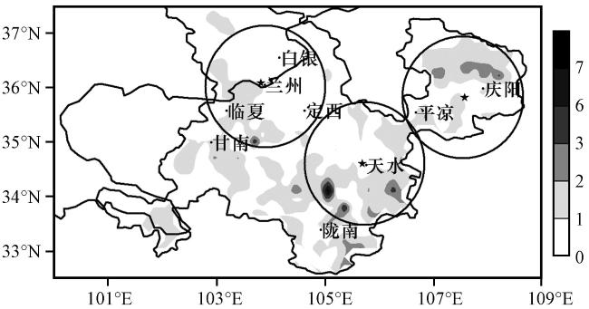
图1 2010 -2015年甘肃河东地区6 -8月短时强降水年平均发生次数的空间分布(单位: 次)五角星表示雷达站位置, 圆区表示雷达水平120 km的探测范围 Fig.1 The spatial distribution of annual average occurrences of short-term heavy precipitation from June to August in East Gansu Province from 2010 to 2015.Unit: times.The five-pointed star indicates the position of the radar station, and the circle indicates the detection range of 120 km away from the radar station |
表2 短时强降水天气过程及观测实况Table 2 The short-term heavy precipitation weather process and observation |
| 天气过程 (年-月-日) | 主要影响系统 | 短时强降水实况 | ||||||
|---|---|---|---|---|---|---|---|---|
| 500 hPa | 700 hPa | 地面 | 站次 /次 | 最大小时 降水量/mm | 集中时段 | 主要落区 | ||
| 2010-08-07 | 西北气流 | 切变线 | 辐合线 低压倒槽 | 33 | 77.3 | 07T18:00/08T04:00 | 中部 | |
| 2010-08-08 | 西北气流 | 切变线 | 辐合线 低压倒槽 | 30 | 64.2 | 08T19:00/09T09:00 | 河东南部 | |
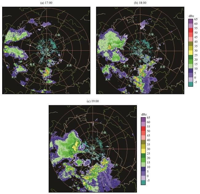
| 2011-07-20 | 西北气流 | 切变线 | 辐合线 | 40 | 71.7 | 20T18:00/21T02:00 | 陇东南 | |
| 2011-07-28 | 高空低槽 | 冷式切变线 低空急流 | 弱冷锋 | 50 | 40.5 | 28T06:00/29T02:00 | 陇东南 | |
| 2011-08-15 | 高空低槽 西太副高 | 冷式切变线 | 弱冷锋 | 64 | 64.2 | 15T13:00/16T04:00 | 陇东南 | |
| 2012-07-21 | 高空低槽 | 冷式切变线 | 辐合线 | 32 | 50.7 | 20T20:00/21T12:00 | 陇东南 | |
| 2012-08-13 | 西北气流 | 切变线 | 辐合线 低压倒槽 | 108 | 92.5 | 13T20:00/14T08:00 | 陇东南 | |
| 2012-08-16 | 高空低槽 西太副高 | 冷式切变线 | 辐合线 | 64 | 71.1 | 16T19:00/17T18:00 | 河东大部 | |
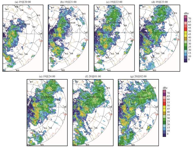
| 2013-06-20 | 高空低槽 | 冷式切变线 低空急流 | 辐合线 弱冷锋 | 191 | 65.0 | 19T20:00/20T13:00 | 陇东南 | |
| 2013-07-08 | 高空低槽 | 低涡切变线 低空急流 | 辐合线 | 51 | 54.4 | 08T09:00/08T17:00 | 陇东南 | |
| 2013-07-21 | 高空低槽 | 冷式切变线 低空急流 | 弱冷锋 | 138 | 82.3 | 21T18:00/22T06:00 | 陇东南 | |
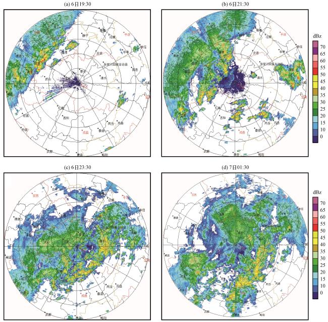
| 2013-08-06 | 高空低槽 西太副高 | 低涡切变线 | 辐合线 | 152 | 59.9 | 06T17:00/07T08:00 | 河东大部 | |
| 2013-08-27 | 高空低槽 西太副高 | 冷式切变线 低空急流 | 弱冷锋 | 101 | 76 | 27T18:00/28T06:00 | 河东大部 | |
| 2014-06-18 | 高空低槽 | 冷式切变线 | 辐合线 | 79 | 54.1 | 18T17:00/19T05:00 | 河东大部 | |
| 2015-08-02 | 高空低槽 西太副高 | 冷式切变线 | 辐合线 | 95 | 52.3 | 02T12:00/03T16:00 | 河东大部 | |
陇东南指陇南、 天水、 平凉、 庆阳四市; 中部指兰州、 白银、 甘南、 临夏、 定西等五市州。 |
3 环流形势配置
3.1 高原槽东移型
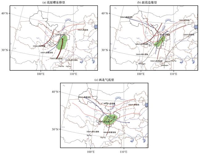
3.2 副高边缘型
3.3 西北气流型
4 雷达回波特征分析
表3 不同环流形势下造成短时强降水的对流系统雷达回波特征Table 3 The radar echo characteristics of convective system under different circulation patterns |
| 高原槽东移型 | 副高边缘型 | 西北气流型 | |
|---|---|---|---|
| PPI特征 | NNE-SSW向中β尺度层积混合性带状回波, 中间常有一条或多条强度>35 dBZ的强中尺度对流回波带; 强中心<45 dBZ, 平均值为42 dBZ | NE-SW向>35 dBZ的窄带状回波, 中β尺度, 强回波范围比高原槽东移型小; 强中心>50 dBZ, 平均值为53 dBZ | 分散的中γ尺度块状回波, 有时呈带状飑线, 尺度较小, 维持时间比副高边缘型短; 强中心>55 dBZ, 平均值为57 dBZ |
| VCS特征 | 回波质心低, 回波顶较为整齐, >40 dBZ强回波在5 km以下 | 中部地区生成时回波质心高, 发展旺盛的单体具有悬垂结构, 移至陇东南时, 质心降低 | 回波质心高, 回波顶参差不齐, 伴有悬垂或穹窿结构 |
| 回波演变 | 带状回波位置和强度稳定维持, 常伴有“列车效应”, 小地形附近多对流风暴生成 | 自西北向东南快速移动, 有时形成弓形回波, 强中心逐渐减弱, 质心逐渐降低, 降水效率有所增加 | 移动缓慢, 局地生消、 组织、 合并 |
4.1 高原槽东移型
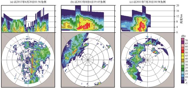
4.1.1 雷达回波结构特征

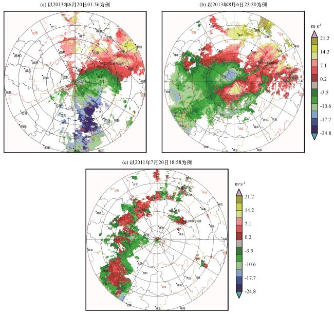
图3 甘肃河东地区不同环流形势下短时强降水天气的FY_2E云顶亮温TBB(单位: ℃)Fig.3 The FY_2E cloud top brightness temperature distribution of short-term heavy precipitation weather for eastward moving plateau low trough pattern, and edge of subtropical high pattern, and northwest airflow pattern in East Gansu Province.Unit: ℃ |
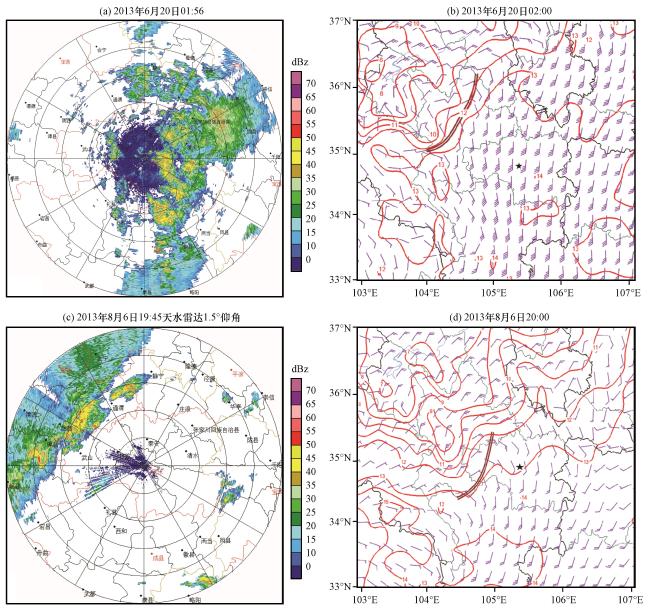
图4 甘肃河东地区高原槽东移型(a、 b, 以“2013·06·20”过程为例)、 副高边缘型(c、 d, 以“2013·08·06”过程为例)短时强降水天气的雷达PPI(距离圈30 km, 下同)和700 hPa风场(风羽, 单位: m·s-1)、 温度场(等值线, 单位: ℃)双实线是切变线、 五角星是天水雷达位置 Fig.4 The radar reflectivity at elevation 1.5° (range ring: 30 km, the same as below), and wind field (the barb, unit: m·s-1) and temperature (contour, unit: ℃) of 700 hPa for eastward moving plateau low trough pattern (a、 b, take "2013.06.20" weather process as an example) and edge of subtropical high pattern (c、 d, take "2013.08.06" weather process as an example) in East Gansu Province.The double solid line represents wind shear, the five-pointed star indicates the position of Tianshui weather radar station |