
1 引言
城市热岛效应是指城市气温明显高于郊区的现象(Oke, 1982), 其主要原因是城市建筑物、 街道等不透水面能吸收更多太阳辐射因此升温较快, 且大量的人为热源对大气存在加热作用(张兆明等, 2005)。随着人类社会不断发展, 城市热岛效应已经成为区域气候变化的重要因子, 对局地高温热浪事件(谢志清等, 2015)、 城市居民舒适度(Steeneveld et al, 2011)等产生了重要影响。
目前利用观测数据对城市热岛效应的研究方法已较为成熟。乔治和田光进(2015)利用MODIS卫星地表温度产品和同心圆法分析了北京市的热岛足迹, 发现夏季热岛足迹扩展趋势显著大于其他季节。赵亚芳等(2017)研究表明, MODIS遥感数据质量受大气稳定度的影响, 但在各类稳定度条件下, 城市下垫面气温始终高于其他下垫面。Schwarz et al(2011)利用多种热岛强度指数对263个欧洲国家展开分析, 最后认为不同类型的指数会对分析结果产生较大影响, 因此在研究时应当慎重选择。谢志清等(2017)利用夜间灯光遥感数据定义了地区发展程度, 从而建立城市规模与热岛强度的时空关系, 最终认为城市群的发展已经改变了长江三角洲区域极端高温事件空间格局。Rozenfeld et al(2008)在研究城市人口增长时提出了城市聚类法(City Clustering Algorithm, CCA), 对城市和非城市进行划分; Peng et al(2012)和Zhou et al(2013)分别在研究全球和欧洲的城市热岛效应时, 基于CCA计算了城市和郊区的平均温度差异, 从而构建了较为合理的热岛强度指数; 王靓等(2015)同样利用CCA提取了北京市的主要城建区范围, 并以此对当地2005 -2014年热岛强度时空格局展开了深入分析。
数值模拟也是研究热岛效应的常用方法。Zhang et al(2017)利用WRF(Weather Research and Forecasting)模式对俄克拉荷马的城市热岛效应进行模拟分析, 通过与实际观测对比, 认为模式能较好地模拟城市对局地温度、 风向风速等气象要素的影响。Chen et al(2011)总结了近年来数值模式在城市气象研究中的应用状况, 并认为针对城市气象中的多尺度特征, 应将不同尺度数值模式进行耦合使用。Chen et al(2014)及Zhang(2007)分别利用耦合了城市冠层模型的WRF模式和RAMS模式对中国杭州和重庆进行了热岛效应模拟, 结果表明耦合模式能更好地模拟出热岛效应的时空特征。Tian et al(2017)通过将全球尺度(25 km)模式模拟结果, 降尺度至中尺度(1 km)和城市尺度(100 m), 从而为城市规划和设计提供多尺度数值模拟服务; Fang et al(2004)通过耦合区域微尺度模式、 城市微尺度模式和城市次网格模式, 搭建了多尺度数值模式系统, 为北京市的城市规划、 通风廊道设计等工作提供了重要支撑。
众多研究表明, 城市热岛强度主要受下垫面规划、 人类活动强度、 气象和地理位置等因素影响, 而其中下垫面条件可通过调整建设模式而改变(朱玲等, 2018), 因此是缓解热岛效应的重要方法。海绵城市是针对我国当前城市水危机提出的生态化、 低影响化城市建设模式, 通过规划大量绿地设施及使用透水性较好的建筑材料, 减少城市发展对水文环境的干扰(仇保兴, 2015)。同时, 海绵城市的绿地规划作为下垫面“冷源”还能对降低城市热岛效应起到重要作用(束方勇, 2017)。朱玲等(2018)利用遥感数据分析了贵安新区的热岛强度, 认为海绵城市规划中的水体将有利于城市降温、 增湿、 加强空气流通、 改变局地微气象条件。宋雯雯等(2018)利用MODIS遥感数据分析了遂宁市的城市热岛, 认为海绵城市建设增加了遂宁市主城区的绿地面积、 水域面积, 使城市建设更加合理, 一定程度上缓解了当地的热岛现象。
然而, 当前相关领域对海绵城市的研究主要针对其内涝防治效果, 对其热岛减缓效果的研究依然较少。充分了解海绵城市规划对城市热岛带来的影响, 不仅应当对海绵城市建成前后的热岛效应进行纵向对比, 还应将其与采用传统城市规划的地区进行横向比较。重庆市悦来新城在2011年的重庆市城乡总体规划中, 被定义为“两江现代国际商务中心”并开始大规模建设, 同时也是国内首批海绵城市试点单位之一。因此, 利用卫星遥感数据, 以悦来新城为研究对象, 将其与采用传统城市规划的新建城区—重庆市龙兴镇和采用传统城市规划的老城区—重庆市观音桥商圈进行对比; 同时结合多尺度数值模拟, 在悦来进行土地利用规划方案敏感性试验, 从而实现对海绵城市热岛效应的综合性、 系统性评估, 以期对该研究领域进行补充。
2 资料选取和方法介绍
2.1 遥感资料
地表温度遥感数据使用了2004 -2017年的MODIS 8日合成地表温度产品, 空间分辨率为1 km, 并以热岛强度最明显的夏季作为研究时间段。由于重庆市常年多云雾, 造成资料很多缺测, 因此参照Crosson et al(2012)的研究, 将TERRA星数据(MOD11A2)和AQUA星数据(MYD11A2)进行结合。具体做法为以MYD11A2为基准数据, 逐点计算与MOD11A2的多年夏季平均值之差; 而在后续数据处理中遇到每一个MYD11A2数据缺测像元时, 都用MOD11A2对应点的像元值加上气候差异做替换, 从而完成缺测数据填补。
地形高度数据使用了NASA根据航天干涉成像雷达技术制作的SRTM1数据, 空间分辨率30 m。土地利用数据使用了清华大学基于Landsat Thematic Mapper和Enhanced Thematic Mapper Plus数据制作的, FROM-GLC土地利用数据(Gong et al, 2013), 时间基点为2017年, 空间分辨率30 m。
2.2 城市热岛定义
计算城市热岛强度的关键在确定城市和郊区。根据图1[该图及其文中涉及包含国界、 省界的地图是基于国家地理信息公共服务平台地图服务的审图号为GS(2019)1719号-甲测资字1100471的中国地图(世界地图)制作, 底图无修改]可知, 由于重庆市土地利用类型分布复杂, 地表形态以山地、 丘陵为主(姜平等, 2019), 仅凭人工经验判断城市区域势必造成较大误差, 因此本研究通过城市聚类法结合地形高度完成对城市和郊区的定义。城市聚类法(City Cluster Algorithm, CCA)是由Rozenfeld et al(2008)提出的一种快速划分城市与郊区的方法, 类似火灾蔓延模拟。它通过选择初始“着火点”, 逐步“引燃”周围的“可燃点”(即城市类型下垫面)进而划分出城市的范围。其主要步骤为: (1)随机选取某个城市像元为起点, 利用八领域法搜索满足条件的像元最终得到连通域; (2)重复步骤(1)多次得到若干连通域, 并将距离小于L的连通域设为同一城市群落; (3)定义阈值S, 去除像元数小于S的小面积城市群落。另外, 根据Zhou et al(2013)的研究, 城市热岛效应的外围最小影响范围为城市面积的1.5倍, 因此同样将城市周边1.5倍城市面积大小的区域也包含在分类结果中。图1(b)所示即为CCA分类得到的结果, 其中斜杠阴影覆盖部分为算法所得的城市区域。
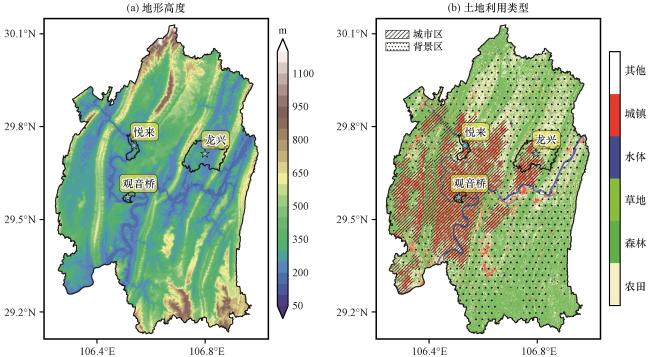
由于重庆主城区各地地形落差较大, 为更合理地计算背景温度, 这里首先计算了城市区的平均地形高度, 然后在剩余区域中选择与其高度差异不超过200 m的地区作为背景温度的计算区[图1(b)中斑点阴影]。可见选择出的背景区大多属于地势平坦的农村, 有较好的代表性。最终城市热岛指数便可定义为城市区的平均温度减去背景区的平均温度, 即: , 以作为热岛强度的判据; 同时, 利用整个温度场减去背景温度, 并参考“等间距分级法”(陈松林和王天星, 2009)按表1进行分类和重新赋值, 即可得到城市的热岛强度空间分布。
表1 热岛强度等级划分Table 1 Classification of urban heat island intensity |
| 温差范围/℃ | 热岛强度等级 | 赋值 |
|---|---|---|
| >5 | 强热岛 | 3 |
| 3~5 | 中等热岛 | 2 |
| 1~3 | 弱热岛 | 1 |
| -1~1 | 无热岛 | 0 |
| -3~-1 | 弱冷岛 | -1 |
| -5~-3 | 中等冷岛 | -2 |
| <-5 | 强冷岛 | -3 |
2.3 数值模式介绍及试验设计
2.3.1 模式简介
为减少地域性气候差异的影响, 还应对海绵城市热岛效应做纵向比较, 分析不同土地利用规划方案在悦来本地产生的气候差异, 因此需进行数值模拟敏感性试验。由于悦来城区面积较小(仅不到20 km2), 若完全使用区域模式进行高分辨率模拟将大幅增加计算量且极易出现积分不稳定。因此研究中采用区域模式配合微尺度模式进行了多尺度数值模拟, 即: 使用区域模式得到当地典型高温月份模拟结果, 后将该结果作为初边条件, 驱动微尺度模式进行微气候诊断模拟, 最终得到精细化的逐小时微气候稳态(Fatima and Chaudhry, 2017; 秦文翠等, 2015)。
研究使用Weather Research and Forecasting Model(WRF)模式V3.8.1版本作为区域模式。WRF模式是由美国国家大气研究中心NCAR、 美国国家环境预报中心NCEP和美国国家海洋和大气管理局NOAA等多家机构联合开发的新一代中小尺度天气预报模式(Wang et al, 2012), 在气象领域已有大量应用。使用重庆-南京大学微尺度模式(CNMM, 简称微尺度模式)做精细化诊断模拟。该模式是在南京大学微尺度模式(Wang and Jing, 1998; 蒋维楣等, 2009)和南京大学微尺度模式(苗世光等, 2002; 张宁等, 2002)基础上发展而来(刘晓冉等, 2020), 后两者也是北京气候中心多尺度数值模式系统的组成部分(Fang et al, 2004)。模式采用Klemp质量-地形跟随坐标系(Klemp, 2011; 张旭等, 2015), 使用非静力平衡大气方程组并根据k-ε假设进行湍流参数化; 利用强迫-恢复法(Dickinson, 1988)并根据网格中不同土地利用类型占比计算最终地表及土壤温度。
2.3.2 模式参数设置
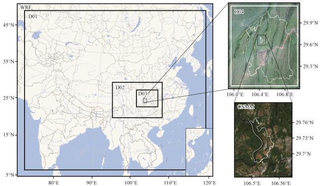
WRF模式采用四层嵌套网格, 由外至内水平分辨率分别为27, 9, 3和1 km, 垂直方向46层。模拟所用主要物理参数化方案包括: KF积云对流方案, WSM6微物理方案, Goddard短波辐射方案, RRTM长波辐射方案, Noah陆面模式, MYJ边界层参数化方案。城市微尺度模式以悦来为中心, 水平分辨率80 m, 垂直方向61层, 模式顶距地面约2500 m。
WRF使用1°×1°的FNL再分析资料作为初始场和边界。以2018年7月作为典型高温月份, 模式模拟时间为2018年6月25日08:00(北京时, 下同)至8月1日00:00, 前5天作为spin-up舍去, 保留最内层整个7月逐小时输出。为使模拟结果更加准确, 使用重庆地面自动气象站观测进行了逐小时四维资料同化(Yubao et al, 2007); 并使用SRTM1地形数据和清华大学土地利用数据对WRF模式原有下垫面资料进行了订正。微尺度模式使用WRF输出的各模式变量计算逐小时月平均值作为初始场并做逐时诊断模拟; 入流方向的风场使用Davies边界条件进行强迫, 出流方向的风场及其他模式变量的侧边界均使用无梯度边界条件; 模式顶边界使用海绵边界条件, 底边界利用M-O假设近似计算得到(Park et al, 2015)。WRF模式和城市微尺度模式均选择自适应积分步长以保证积分连续稳定。图2给出了WRF和微尺度模式的网格嵌套关系。
由于微尺度模式模拟分辨率较高, 模式动力部分积分步长需很短才能保证稳定; 而辐射热力模型则无严格限制。因此为加快土地利用改变产生的影响, 参照王宝民等(2004)的研究方法, 将模式诊断的模拟步骤设置为: 首先, 保持动力场不变, 仅计算辐射热平衡过程, 然后再进行辐射热平衡和动力过程的同步积分; 重复上述两步, 直至动力场达到相对稳态便停止模拟。该模拟结果可用于表示局地微气候的某种特征趋势。
3 基于遥感的热岛效应分析
3.1 热岛效应年际变化
为对海绵城市的热岛效应做横向比较, 对比不同类型城市间热岛效应差异, 研究中选择与悦来发展时间接近、 城市化程度相当的龙兴镇代表“采用传统城市规划的新建城区”, 选择观音桥街道代表“采用传统城市规划的老城区”。从悦来、 龙兴和观音桥的逐年夏季热岛指数时间变化曲线[图3(a)]中可以看出, 观音桥作为发展成熟的商业中心, 其多年热岛强度无明显变化, 且在早年远高于另外两个地区。而悦来和龙兴的热岛强度随时间呈缓慢增加的趋势, 从2011年左右增速开始加快, 这与两地的开发时间较为吻合。到2015年左右, 龙兴的热岛强度已与观音桥相当; 到2018年, 悦来、 龙兴和观音桥的热岛指数分别为4.3、 6.3和6.2, 可见采用传统城市建设的龙兴其热岛强度已与观音桥基本相当; 而不论哪个年份, 悦来的热岛强度都低于龙兴, 且增长趋势较为缓和。
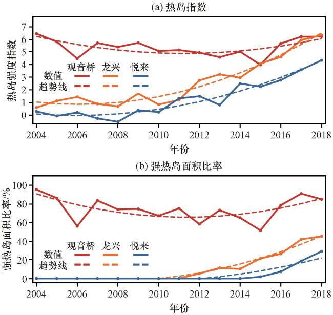
从悦来、 龙兴和观音桥的逐年夏季强热岛面积比率[图3(b)]中可以看出, 虽因气候变化存在波动, 但观音桥地区常年以强热岛为主。龙兴在2012年左右开始出现强热岛, 其面积比率随年份递增, 到2018年强热岛面积已占龙兴面积的45%; 而悦来在2015年左右才开始出现强热岛, 且其变化趋势较龙兴更为缓和, 到2018年其强热岛面积占29%, 较龙兴更少。
3.2 热岛效应空间特征分析
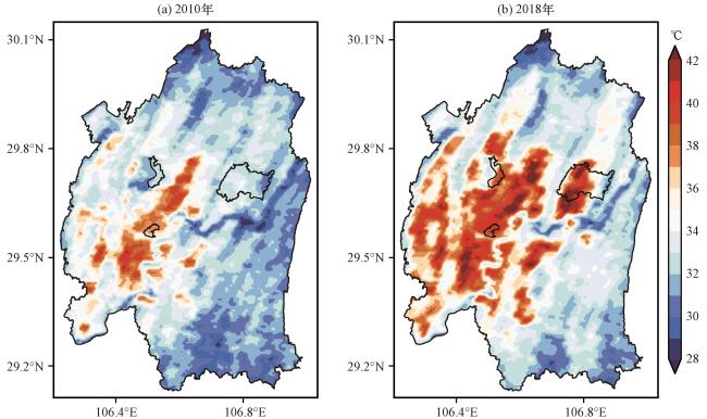
从重庆市主城区2010年和2018年夏季平均地表温度(图4)中可以看出, 近年来由于重庆市高速发展导致城市热岛效应增强, 高温区域明显增多。观音桥自2010年温度便相对周围较高, 悦来和龙兴由于还未发展, 并未有明显的高温中心; 到2018年, 能注意到龙兴中西部出现了超过42 ℃的高温, 而悦来温度空间分布相对均匀。
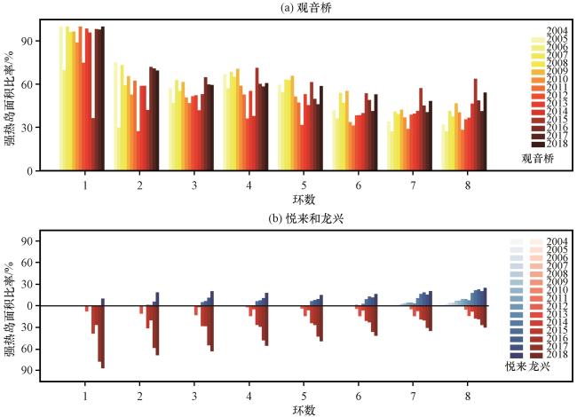
同心圆法(乔治和田光进, 2015)是研究热岛空间特征的常用方法, 为对比海绵城市与传统城市的热岛空间分布差异, 本研究以悦来、 龙兴和观音桥的中心为圆点, 间隔1 km设置了同心圆环区。通过2004 -2018年观音桥、 悦来和龙兴8圈同心圆各环强热岛面积比(图5)可以看出, 观音桥强热岛面积比率随环数增加而逐步减少, 龙兴的强热岛空间变化趋势与观音桥一致, 说明采用传统城市规划的新、 旧城建区拥有相似的热岛空间特征, 即强热岛主要来自本地的城市发展; 而悦来则表现为强热岛面积比率随圆环半径增加而增加, 其中2018年之前该特征更为明显, 说明悦来的强热岛可能多来自周边城市的热岛效应辐射。
4 基于数值模拟的热岛效应分析
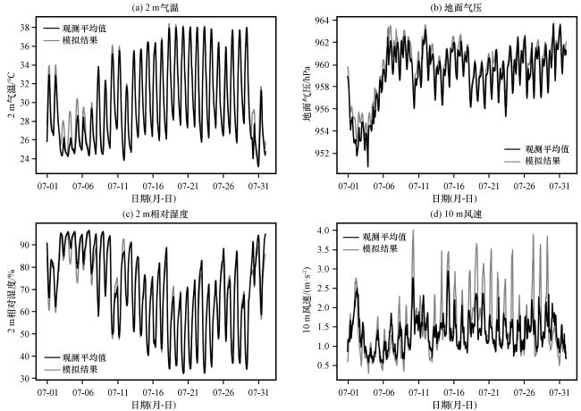
从WRF模拟的10 m风速、 2 m气温、 2 m相对湿度和地面气压插值到重庆市主城区各气象站后的平均值与实际观测平均值时间序列(图6)中可以看出, 气温、 气压和相对湿度的模拟值和变化趋势均与观测基本一致; 模拟的风速由于是瞬时值因此较观测偏大, 但二者变化趋势也较为接近。因此可使用该结果作为本地2018年7月气象特征的近似。
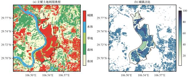
根据规划文件, 悦来新城海绵城市的建设包括了公建民建小区、 城市水系、 市政道路、 园林绿地等75个项目, 其中绿化率的增加及合理的城市规划是建设方案的重要组成部分。由于透水海绵材料的使用对热岛效应影响较小且难以在模式中表达, 这里主要考虑对比海绵城市与传统城市土地利用规划方案对局地微气候产生的不同影响。因此, 微尺度模拟设计了三组试验: (1)试验1(Exp1): 根据悦来海绵城市规划方案, 修改了模式中悦来行政区划内的土地利用类型, 同时将规划数据中的不透水面比率作为城市土地利用所占比重。悦来行政区之外的城市部分则按中国《城市道路绿化规划与设计规范》(中国城市规划设计研究院, 1998)将绿化率设为25%, 最终得到的模拟区域土地利用及城市比重(图7)。(2)试验2(Exp2, 图略): 根据传统城市规划, 将悦来行政区内的土地利用类型全部修改为城市, 绿化率均为25%。(3)试验3(Exp3, 图略): 悦来行政区内的绿化率设为Exp1中对应区域的平均绿化率(约40%), 其余与Exp2相同。
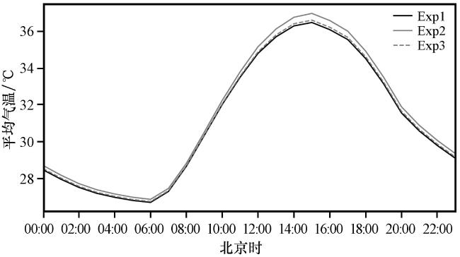
由于微尺度模拟空间范围较小, 难以区分“城市”和“郊区”并计算热岛强度指数。考虑到实际中更关注行人高度的气象条件, 因此进行逐小时诊断模拟后, 主要对三组试验悦来行政区内的近地面气象要素展开分析。对比三个试验方案的悦来边界内逐小时平均2 m气温(图8)可知, 单纯增加绿化(Exp3)和采用海绵城市规划(Exp1)相比传统城市规划(Exp2)都能起到降温的效果; 而海绵城市规划方案的降温效果略优于单纯增绿的方案。Exp1相对Exp2和Exp3的最大温差出现在15:00左右, 分别达到-0.5 ℃和-0.13 ℃。
7月午后悦来地区入流风为东南风, 与当地实际观测较为一致; 同时模式也较好地模拟出了城市区域的高温及河道上空的低温。由温度场可知, 采用传统城市规划[图9(b)]时悦来南部和北部均存在较大面积的高温中心, 表现为明显的“热岛”; 而整体增加绿化率后[图9(c)], 尽管悦来北部的高温有所缓解, 但南部片状高温中心依然较大; 当采用海绵城市规划后[图9(a)], 高温被分散式的绿地切割, 悦来南部和北部的高温中心均明显缩小。综合对比可知, 海绵城市规划方案中个别局部高密度城建区的温度其实并不比单纯提高整体绿化率的试验结果更低, 但结合图8可知海绵城市规划全区平均气温是三组试验中最低的, 这说明采用海绵城市规划相比单纯地提高整体绿化率能更有效地减缓当地热岛效应, 同时也使城市功能区的布局更加合理。
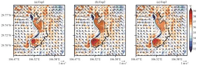
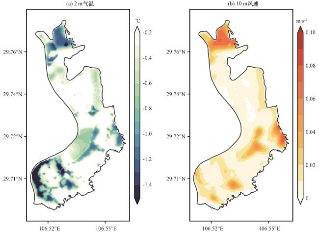
图10为Exp1和Exp2在16:00的2 m气温和10 m风速差异。由图10(a)可知, 采用海绵城市规划后悦来大部分地区都有降温趋势, 最大降温位于悦来北部的保留林地和中部、 南部的景观绿地区。根据图2 的地形分布, 悦来中部属于背风坡洼地, 容易形成局地高温中心; 而采用海绵城市规划后, 各类景观绿地和防护林以及城建区合理的绿化率布局共同形成了若干零星冷源, 使高温难以聚集。风速[图10(b)]则主要在悦来西南部及北部等规划城市比重较低的区域增加趋势较明显。结合图9的风向, 可知对夏季白天盛行东南风的悦来, 采用海绵城市规划后改善了局部通风环境, 在中部和西部构造了新的风道, 能有益于热量扩散。
5 结论
利用卫星遥感资料, 结合考虑了复杂地形情况的城市聚类法定义了新的热岛强度指数, 对采用海绵城市规划的新建城区与采用传统城市规划的新建城区和老城区进行了横向比较; 又利用数值模拟手段, 在悦来本地进行土地利用规划方案敏感性试验, 将不同城市规划方案做了纵向对比, 最终得到如下主要结论:
(1) 利用卫星遥感资料进行的热岛强度时间变化分析表明, 2018年悦来平均热岛强度指数约4.3, 低于龙兴的6.3和观音桥的6.2; 且悦来地区的热岛强度随时间增长相对缓和。同时, 2018年悦来强热岛面积约占当地29%, 明显小于龙兴的45%, 且强热岛出现时间相对龙兴也更晚。这说明海绵城市规划方案较传统城市规划方案能一定程度上减缓热岛效应的强度和增长速度。
(2) 对热岛的空间特征分析表明, 悦来的强热岛面积比率随到城市中心距离增加而增加, 而龙兴和观音桥则表现为强热岛面积比率随到城市中心距离增加而减少。这说明传统城市的强热岛主要源于自身的城市建设, 分布更加集中; 而海绵城市的强热岛则主要来自周边城市的热岛效应辐射, 其自身的热岛空间分布较为分散。
(3) 利用多尺度数值模式的模拟试验表明, 单纯将区域平均绿化率调整到与海绵城市一致水平的规划方案, 虽然相比传统城市规划方案能起到一定的降温作用, 但海绵城市方案模拟得到的平均温度却依然是三组试验中最低: 15:00平均气温相比传统规划方案和单纯增绿方案下降了各约0.5 ℃和0.13 ℃。这说明海绵城市规划通过合理的土地利用空间布局, 更好地缓解了热岛效应。
(4) 从规划前后气温和风速的空间差异来看, 海绵城市规划方案通过布置零散的绿地, 使高温中心被分割, 难以聚集; 同时也改善了城市的局部通风环境, 进而有助于热量扩散。
本文虽然对悦来海绵城市的热岛效应进行了较为全面地分析, 但当地的城市建设还在进行中, 实际建成后的热岛强度有待利用气象站监测数据做进一步评估。同时, 虽然利用城市微尺度模式进行了数值模拟, 但由于进行的是稳态模拟, 结果更多体现的是一种变化趋势, 还有待进一步观测验证。同时, 为更全面客观地对海绵城市规划进行研究, 还应在其他采用了传统城市规划方案的地区进行土地利用敏感性试验, 以减少地区差异的影响。这些都将是未来的重点研究方向。