1 引言
2 模拟区域与观测数据
表1 站点基本信息Table 1 Basic infomaition of observations |
| 站号 | 经度/°E | 纬度/°N | 海拔/m | 分类 |
|---|---|---|---|---|
| A0358 | 116°6′14.04″ | 39°56′27.96″ | 98 | 平原 |
| A1381 | 116°6′33.84″ | 39°54′51.12″ | 96 | 平原 |
| 54505 | 116°9′23.04″ | 39°53′16.08″ | 86 | 平原 |
| A1036 | 116°9′27.00″ | 39°55′59.88″ | 91 | 平原 |
| A1066 | 116°6′50.04″ | 39°51′25.92″ | 119 | 山麓 |
| A1109 | 116°7′32.16″ | 39°57′47.16″ | 143 | 山麓 |
| A1067 | 116°4′18.12″ | 39°52′08.04″ | 427 | 丘陵 |
A为区域站, 54505为国家一般气象站 |
3 模式设置和试验设计
3.1 模式参数设置
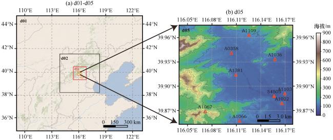
图1 模式嵌套示意图(a)和最里层D05的地形分布(b)空心三角形代表区域站, 实心三角形代表国家一般气象站 Fig.1 Simulation domains (a) and the terrain distribution of D05 (b).Hollow triangle represents the Regional Station, solid triangle represents the National General Weather Station |
表2 模式逐层嵌套网格参数设置Table 2 Domain size, grid spacing and time steps used in the WRF model simulations of each nested domain |
| 嵌套层 | 网格数 | 水平分辨率 | 水平跨越/km | 时间步长/s |
|---|---|---|---|---|
| D01 | 121×121×40 | 9 km | 1089 | 18 |
| D02 | 121×121×40 | 3 km | 363 | 6 |
| D03 | 121×121×40 | 1 km | 121 | 2 |
| D04 | 121×121×40 | 333 m | 40.29 | 0.667 |
| D05 | 121×121×40 | 111 m | 13.43 | 0.222 |
表3 WRF和WRF-LES模式物理参数设置Table 3 Physical schemes used in WRF and WRF-LES models |
| 模式 | 物理参数化方案 |
|---|---|
| WRF | Kain-Fritsch积云方案 |
| YSU边界层方案 | |
| Thompson微物理方案 | |
| RRTM长、 短波辐射方案 | |
| MM5近地层方案 | |
| Noah陆面过程方案 | |
| WRF-LES | 3阶Runge-Kutta时间集成 |
| 1.5TKE, SMAG, 1.5TKE_NBA, SMAG_NBA湍流方案 | |
| 6阶数值离散方案 |
3.2 亚网格模型介绍
3.2.1 标准的WRF-LES亚网格模型
3.2.2 NBA模型
3.3 试验设计
表4 边界层敏感性试验设计Table 4 Experimental design of atmospheric boundary layer sensitivity |
| 组别 | 试验名称 | 边界层参数 | ||
|---|---|---|---|---|
| 中尺度嵌套 (dx, dy=9 km, 3 km) | 1 km嵌套 (dx, dy=1 km) | 微尺度嵌套 (dx, dy=333 m, 111 m) | ||
| 试验一 | 1 km-YSU | YSU | YSU | LES(1.5TKE) |
| 1 km-LES | YSU | LES(1.5TKE) | LES(1.5TKE) | |
| 试验二 | 1.5TKE | YSU | YSU | LES(1.5TKE) |
| SMAG | YSU | YSU | LES(SMAG) | |
| 1.5TKE_NBA | YSU | YSU | LES(1.5TKE_NBA) | |
| SMAG_NBA | YSU | YSU | LES(SMAG_NBA) | |
4 模拟结果检验与分析
4.1 1 km边界层方案敏感性试验
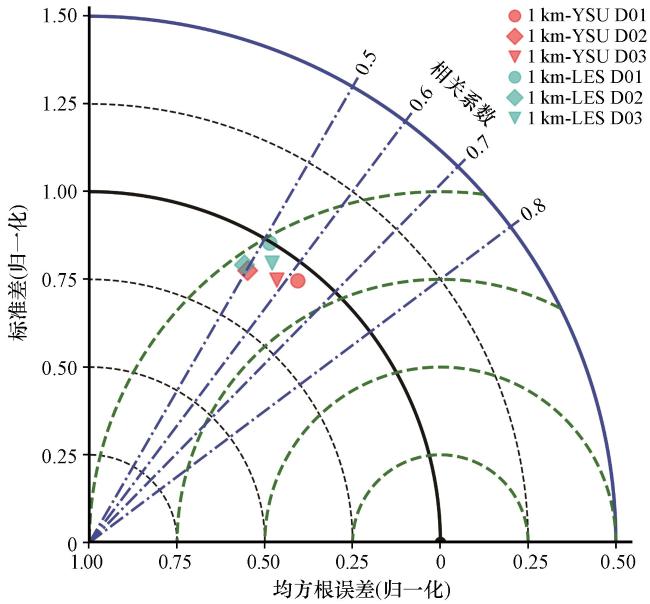
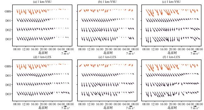
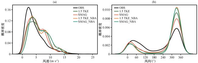
图3 站点54505(a, d)、 站点A1066(b, e)和站点A1067(c, f)的逐小时风矢量随时间分布橙色代表观测, 深蓝色代表不同嵌套层的模拟结果 Fig.3 Time series of wind directions from simulation and observations at 54505(a, d), A1066(b, e) and A1067(c, f).Orange represents observed data, darkblue represents simulation results from different domain |
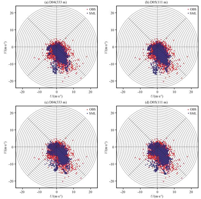
图4 1 km-YSU(a~b)中D04和D05与1 km-LES(c~d)中D04和D05的风矢量散点分布(单位: m·s-1)Fig.4 1 km-YSU(a~b)D04 and D05 and 1 km-LES (c~d) D04 and D05 Wind vector scatter diagram.Unit: m·s-1 |
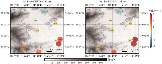
图5 1 km-YSU(a)和1 km-LES(b)的近地面风速偏差和均方根误差空间分布(单位: m·s-1)红色为正偏差, 蓝色为负偏差, 圆圈中数值代表均方根误差 Fig.5 Spatial distribution of near-surface wind deviation and root mean square error of D05 in (a)1 km-YSU (b)1 km-LES.Unit: m·s-1.Red circle means the positive deviation, blue circle means the negative deviation, and the value in the circle represents the RMSE |
表5 1 km边界层方案试验D05近地面风速统计检验结果Table 5 Statistic results of different 1 km boundary layer schemes simulated near-surface wind in D05 |
| 风速 /(m·s-1) | 试验名称 | MB | MAE | RMSE |
|---|---|---|---|---|
| U分量 | 1 km-YSU | 0.8312 | 3.0109 | 3.8487 |
| 1 km-LES | 1.2825 | 3.3975 | 4.2218 | |
| V分量 | 1 km-YSU | -1.6566 | 3.3129 | 4.2202 |
| 1 km-LES | -1.49 | 3.3604 | 4.2398 | |
| 全风速 | 1 km-YSU | 1.2145 | 2.8428 | 3.616 |
| 1 km-LES | 1.3801 | 2.9388 | 3.7067 |
粗体表示多组实验中最优试验 |
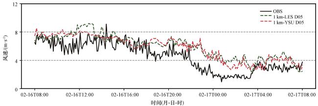
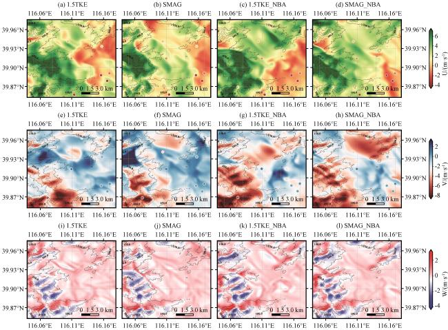
4.2 亚网格模型敏感性试验
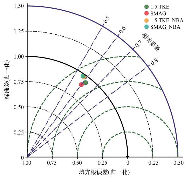
表6 不同亚网格方案D05近地面风速统计检验结果Table 6 Statistic results of different SGS models simulated near-surface wind of D05 |
| 风速 /(m·s-1) | 试验名称 | MB | MAE | RMSE |
|---|---|---|---|---|
| U分量 | 1.5TKE | -1.6566 | 3.3129 | 4.2202 |
| SMAG | -1.1333 | 3.1593 | 4.0579 | |
| 1.5TKE_NBA | -2.0655 | 3.4245 | 4.2763 | |
| SMAG_NBA | -2.0655 | 3.4148 | 4.2451 | |
| V分量 | 1.5TKE | 0.8312 | 3.0109 | 3.8487 |
| SMAG | 0.5117 | 2.9424 | 3.8355 | |
| 1.5TKE_NBA | 1.1544 | 3.0056 | 3.7276 | |
| SMAG_NBA | 1.1486 | 3.0996 | 3.8361 | |
| 全风速 | 1.5TKE | 1.2145 | 2.8428 | 3.616 |
| SMAG | 0.6936 | 2.639 | 3.3505 | |
| 1.5TKE_NBA | 1.518 | 3.0763 | 3.8515 | |
| SMAG_NBA | 1.5123 | 3.1099 | 3.8626 |
粗体表示多组实验中最优试验 |
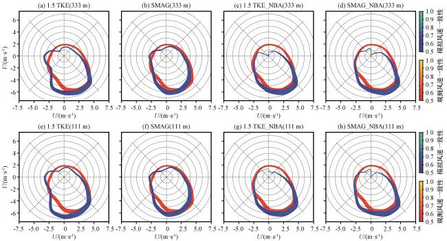
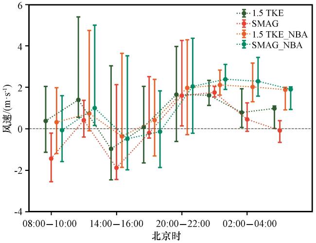
图9 不同方案的误差棒日变化误差棒圆点为每3 h内所有站点误差的中位数, 上下两头分别为75和25分位数 Fig.9 Diurnal variation of 10-m wind speed errors (m·s-1) of each OBS with different SGS models at D05.Markers represent the median error, and whiskers give 25th and75th percentile values for each bin.Bars indicate how much of the total data considered belong in each bin |