

1 引言
2 数据来源及降水概况
2.1 数据资料
2.2 降水概况
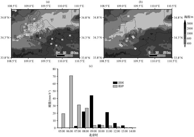
图1 2021年7月18日04:00 -16:00 大于30 mm降水区域(a, 等值线, 单位: mm), 18日04:00 -05:00降水量(b, 等值线, 单位: mm)及泾河站、 铁炉站18日05:00 -14:00逐小时雨强(c)XA为西安, WN为渭南, JH为泾河, LT为临潼; 图(a)、 (b)中阴影为地形(单位: m) Fig.1 Precipitation larger than 30 mm from 04:00 to 16:00 (a, contour, unit: mm), precipitation from 04:00 to 05:00 (b, contour, unit: mm), hourly rain intensity of Jinghe station and Tielu station from 05:00 to 14:00 (c) on 18 July 2021.XA, WN, JH, LT represents Xi’an, Weinan, Jinghe, Lintong, respectively; In Fig.1 (a) and (b), the shaded is Topography (unit: m) |
3 环流形势
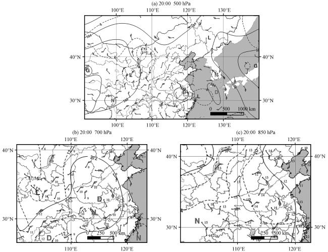
图2 2021年7月17日20:00 500 hPa(a), 700 hPa(b)及 850 hPa(c)环流形势虚线为温度场(单位: ℃), 风向杆为风场(单位: m·s-1), 黑实线为位势高度场(单位: dagpm), 小黑数字为700 hPa和850 hPa比湿(单位: g·kg-1) Fig.2 The circulation situation at 500 hPa (a), 700 hPa (b) and 850 hPa (c) on 17 July 2021.The dotted line indicates temperature field (unit: °C), wind barb indicates wind field (unit: m·s-1), black solid line indicates the potential height field (unit: dagpm), the smaller black number indicates specific humidity (unit: g·kg-1) |
4 突发性大暴雨的环境场条件
4.1 探空分析
4.2 突发性大暴雨发生前地面弱降水的作用
4.3 突发性大暴雨的水汽和能量条件
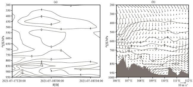
图6 2021年7月17日20:00至18日05:00大暴雨区附近(34.75°N, 109.75°E) 比湿平流垂直剖面(a, 单位: ×10-5 g·kg-1·s-1)和18日03:00沿34.75°N风场(矢量, 单位: m·s-1)和比湿场(实线, 单位: g·kg-1)的垂直剖面(b)阴影为地形 Fig.6 Vertical section of specific humidity advection (unit: ×10-5 g·kg-1·s-1) near the torrential rain area (34.75°N, 109.75°E) from 20:00 on 17 to 05:00 on 18 July 2021 (a), and vertical section of wind (vector, unit: m·s-1) and specific humidity (solid line, unit: g·kg-1) along 34.75°N at 03:00 on 18 July 2021 (b).The shaded area is terrain |
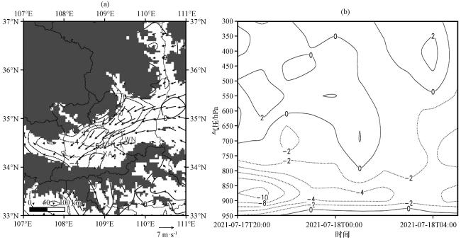
图7 2021年7月18日03:00 900 hPa风场(矢量, 单位: m·s-1)和散度场(等值线, 单位: ×10-5 s-1)(a)和2021年7月17日20:00至18日05:00(109°E, 34.5°N)上升速度垂直剖面(单位: ×10-2 Pa·s-1)(b)(a)中阴影为地形 Fig.7 Superposition of wind field (vector, unit: m·s-1) and divergence field (contour, unit: ×10-5 s-1) of 900 hPa at 03:00 on 18 July 2021 (a), and vertical section of ascending velocity (unit: ×10-2 Pa·s-1) from 20:00 on 17 to 05:00 on 18 July 2021 (b).In Fig.7(a), the shaded area is terrain |
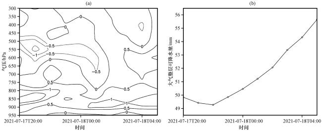
图8 2021年7月17日20:00至18日05:00大暴雨区(109°E, 34.5°N)水汽垂直交换量垂直剖面(a, 单位: ×10-5 g·kg-1·s-1)和大气整层可降水量(b)Fig.8 Profile of water vapor exchange of the torrential rain area (109°E, 34.5°N) (a, unit: ×10-5 g·kg-1·s-1) and precipitable amount of total atmosphere (b) from 20:00 on 17 to 05:00 on 18 July 2021 |
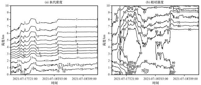
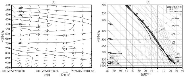
图10 2021年7月17日20:00至18日05:00泾河附近(109°E, 34.5°N)假相当位温(等值线, 单位: K)和风场(矢量, 单位: m·s-1)垂直剖面(a)和T-lnp图(b)Fig.10 Vertical section of pseudo-equivalent potential temperature (contour, unit: K) and wind field (vector, unit: m·s-1) near Jinghe from 18:00 on 17 to 12:00 on 18 July 2021 (109°E, 34.5°N) (a) and T-lnp (b) |
5 中尺度对流系统发生发展演变及触发机制
5.1 中尺度对流系统发生发展演变
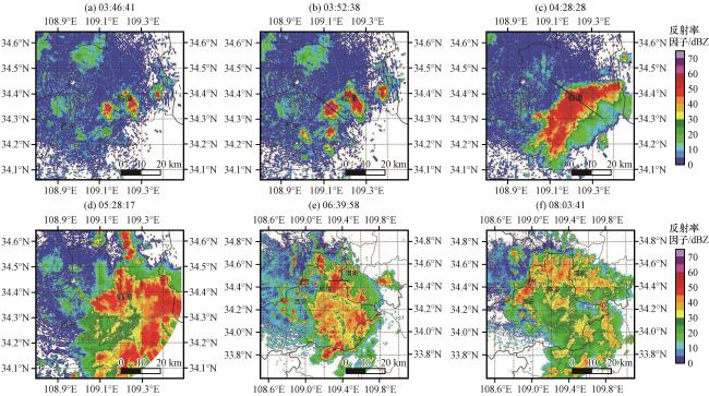
图11 2021年7月18日泾河雷达组合反射率因子(单位: dBZ)Fig.11 Composite reflectivity factor of Jinghe Radar on 18 July 2021.Unit: dBZ |
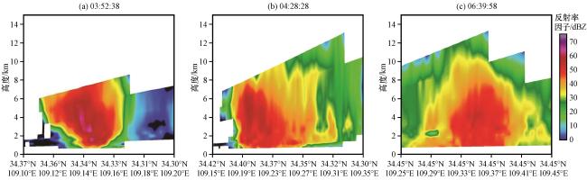
图13 2021年7月18日03:52:38(a), 04:28:28(b)和06:39:58(c)泾河雷达反射率因子垂直剖面(单位: dBZ)Fig.13 Vertical section of composite reflectivity factor of Jinghe radar at 03:52:38 (a), 04:28:28 (b) and 06:0039:58 (c) on 18 July 2021.Unit: dBZ |
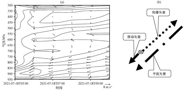
图15 2021年7月18日05:00 -10:00沿暴雨区中心(109.5°E, 34.75°N)风矢量(矢量)和全风速(等值线)垂直剖面(a, 单位: m·s-1)和突发性暴雨区中-β尺度对流系统传播平流移动示意图(b)Fig.15 Vertical section of wind (vector) and full wind speed (contour) along the center of the torrential rain area (109.5°E, 34.75°N) from 05:00 to 10:00 on 18 July 2021 (a, unit: m·s-1), Schematic diagram of propagation and advection of the meso-β scale convective system in an abrupt rainstorm area (b) |
5.2 中尺度对流系统的触发机制
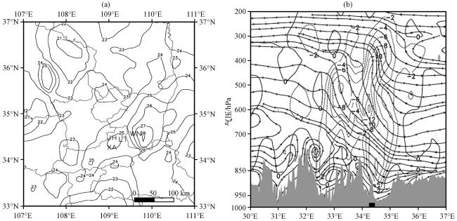


图17 2021年7月18日03:00地面订正到海拔500 m的温度(a, 单位: ℃)和06:00沿着突发性暴雨区(109.25°N)的经向环流(流线)和垂直上升速度(虚线, 单位: ×10-1 Pa·s-1)(b)(b)中阴影为地形, 黑色长方体为骊山 Fig.17 Corrected temperature from ground to 500-metre above sea level at 03:00 (a, unit: ℃), and meridional circulation (streamline) and vertical ascent velocity (dotted line, unit: ×10-1 Pa·s-1) along the torrential rain area (109.25°N) at 06:00 (b) on 18 July 2021.The shaded area is terrain, and the black square is Lishan in Fig.17(b) |