
1 引言
河西走廊气候恶劣, 是丝绸之路的咽喉, 降水少, 蒸发大, 生态环境脆弱, 沙尘天气频繁, 对水资源的需求量越来越多, 祁连山是下游水资源的重要供给者, 其水源涵养能力直接决定下游水资源供给量, 青海云杉林是祁连山主要建群树种, 其涵养水源量为4.66151868×10⁷ m3·a-1(车宗玺等, 2022), 水源涵养功能是生态系统服务功能的首要功能(王云飞等, 2021), 在降水调节、 分配、 存储等方面发挥至关重要作用, 是苔藓、 降雨再分配, 拦截降水及调节径流的能力(李士美等, 2010), 由于各种水热要素的综合影响(气温、 土壤温度、 降水、 土壤水分、 土壤蒸发)水源涵养功能具有时空异质性(吕一河等, 2015), 这些要素如何影响水源涵养功能, 在祁连山区域尚不清楚, 因为不同区域影响程度各异, 虽然现有水源涵养功能与水热要素的影响研究多聚焦于降水和气温2项, 在其他要素对水源涵养功能的影响方面研究不足(Liu et al, 2020; Chen et al, 2022), 张薇等(2025)利用InVEST模型评估了气候及土地利用变化对黄河水源涵养区碳储量的影响; 张子涵等(2023)利用气温、 降水、 风速三者数据分析了黄河上游水源涵养区近60年的关键气候要素变化; 李芳等(2022)基于InVEST模型的黑河流域上游1990 -2018年产水量模拟, 上述研究的共性就是采用模型模拟研究单因子对水源涵养功能的影响(Gao et al, 2021), 多因子的协同影响研究较少, 其次, 缺乏长序列的定位监测数据进行研究。本文利用长序列的定位监测数据, 对祁连山青海云杉林水源涵养功能进行研究, 阐明水热要素对青海云杉林水源涵养功能的影响机制。
目前, 水源涵养功能的评估方法主要有水量平衡法、 林冠截留剩余量法、 降雨储存量法、 地下径流增长法和多因子回归法等多种方法(王晓学等, 2012), 水量平衡法是被广泛应用的方法之一(王玉纯等, 2018; 王耕等, 2018), INVEST模型是水量平衡法的一种典型应用, 主要弊端是需要基础数据多, 有些数据难以获取(马良等, 2015; 王金叶等, 2008; 苑跃等, 2020), 本文采用一般的水量平衡法, 其优点是对森林生态站长期连续观测的降水量、 径流量、 蒸散量等数据利用水量平衡模型估算水源涵养量, 这样可以估算祁连山排露沟流域水源涵养量的空间变化特征, 阐明水源涵养功能的空间变化特征及与水热要素的互作关系。
祁连山是西部重要生态安全屏障, 河西走廊的生命线和母亲山, 是黑河、 疏勒河、 石羊河三大内陆河的水源产流地, 是我国重要的水源涵养功能区, 对维护下游额济纳旗的生态平衡具有举足轻重的作用。近年来, 该区部分湿地干化, 草场退化严重, 土地沙化范围扩大, 灌木林线后移, 青海云杉林分质量下降, 水源涵养功能减弱(熊远清等, 2011; 王辉源等, 2023)引起了一系列生态问题。国内大部分学者从森林水文的过程机理研究了水源涵养功能, 忽略了水源涵养功能的时空变化及水热要素的影响研究, 导致不同生态系统水源涵养功能底数不明, 区域或局域尺度产水量不清, 对下游的调水、 用水造成被动局面。因此, 研究水热要素对祁连山青海云杉林水源涵养功能的影响对评估祁连山青海云杉林涵养水源能力及水资源管理提供科学理论依据。
2 资料与方法
2.1 研究区概况
实验区位于甘肃祁连山国家公园中部西水自然保护站辖区的排露沟流域, 地理坐标100°17′59″E, 38°32′47″N, 总面积2.95 hm2, 海拔2400~3400 m, 流域阳坡为山地草原, 阴坡为青海云杉林, 森林植被空间分布格局明显, 从高到低依次为高山草甸带(分布草本和灌木)、 灌木林带、 青海云杉林带、 半干旱草原带、 荒漠草原带, 森林覆盖率28.6%; 年均气温0.7 ℃, 7月份平均气温10~15 ℃, 年降雨量433.6 mm, 年蒸发量1081.2 mm, 相对湿度60%, 年日照时数1892.6 h, 日辐射总量110.28 J·m-2(车宗玺等, 2018)。研究区内以青海云杉为主要建群种, 呈斑块状分布在海拔2400~3400 m的阴坡或半阴坡; 阳坡、 半阳坡主要为山地草原, 伴生有小灌木。乔木林主要有青海云杉(Picea crassifolia)和祁连圆柏(Sabina przewalskii); 灌木优势种有金露梅(Potentilla fruticosa)、 箭叶锦鸡儿(Caragana jubata)、 吉拉柳(Salix gi-lashanica)等; 草本植物主要有苔草(Cavex )、 针茅(Stipa ssp)、 黄芪(Hedysorum)、 火绒草(Leantopotium)、 白藜(Chenopodium album)、 委陵菜(Poten-tilla)等。
表1 不同海拔梯度样点主要环境要素参数Table 1 The main environmental factors parameters of the sample plots at different altitudinal gradients |
| 海拔/m | 东经(E) | 北纬(N) | 年均温/℃ | 地温/℃ | 降水/mm | 土壤类型 |
|---|---|---|---|---|---|---|
| 2600 | 100°17′3.0″ | 38°33′16.0″ | 1.25 | 1.09 | 361.8 | 森林灰褐土 |
| 2700 | 100°17′10.6″ | 38°33′20.1″ | 0.86 | 0.65 | 368.9 | 森林灰褐土 |
| 2800 | 100°17′7.7″ | 38°33′10.6″ | 0.47 | 0.15 | 423.6 | 森林灰褐土 |
| 2900 | 100°18′10.0″ | 38°32′32.0″ | 0.32 | -0.065 | 467.1 | 森林灰褐土 |
| 3000 | 100°17.971′ | 38°32.588′ | -0.73 | -0.575 | 499.1 | 森林灰褐土 |
| 3100 | 100°18.106′ | 38°32.334′ | -1.45 | -0.96 | 520.3 | 森林灰褐土 |
| 3200 | 100°18.103′ | 38°32.242′ | -1.36 | -1.305 | 530.0 | 森林灰褐土 |
| 3300 | 100°18.265′ | 38°32.152′ | -1.57 | -1.66 | 528.5 | 高山草甸土 |
2.2 观测方法
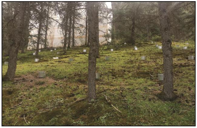
气温、 土壤温度梯度监测: 沿海拔梯度在青海云杉林分布带2600~3300 m范围内, 100 m布设一套土壤温度自动记录仪(HOBO Pro V2, 型号: U12)共8套, 埋入土层深10 cm处, 长期测定土壤温度, 测量范围为-20~70 ℃, 精度±0.4 ℃; 气温采用空气温湿度自动记录仪(HOBO Pro V2, 型号: U23-002)布设在海拔2900~3300 m的取样点附近树高2 m避光一测共5套(图1), 测量范围为-40~70 ℃, 精度±0.2 ℃, 两者记录时间间隔均为1 h, 测定从2004年开始, 至今持续在测定, 利用监测数据分析气温和土壤温度的空间变化。
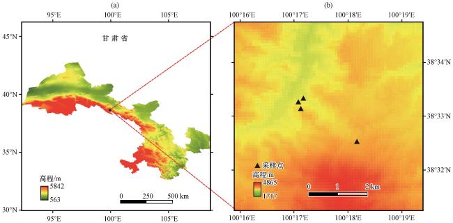
降水监测: 沿海拔梯度2600~3300 m布设了降水观测雨量筒, 每个海拔布设了林外和林空对照观测雨量筒, 从5月降雨开始观测, 到9月底降雨结束为止, 从2004年5月至今持续进行, 每次降雨结束后为防止蒸发立即测定不同海拔降水量。
土壤、 苔藓水分监测: 在青海云杉林分布带海拔2600 m、 2700 m、 2900 m、 3100 m、 3300 m每个海拔段建立长期固定取样点(图1), 共5个, 取样工作从2004年开始至今持续进行, 每年5月初开始, 9月底结束, 按月初、 月中、 月末监测一个生长季, 对21年的监测数据取其均值, 分析空间变化规律。
2.3 数据计算方法
水源涵养量是评价森林水源涵养功能的主要指标, 水源涵养量的高地决定森林水源涵养功能的强弱。根据含水量模型(1)推算苔藓和土壤含水量, 利用降水(P)和径流量(R)结合径流模型(3)可以计算径流系数, 径流系数(α)结合径流模型(2)可以推算地表径流量(R), 同时采用王金叶等(2008)森林生态水文过程研究的排露沟流域不同海拔林地蒸散量(ET)结合水量平衡模型(4)可以计算水源涵养量。
对取回的土壤和苔藓样品带回实验室立即进行烘干测定计算含水量, 土壤烘样温度调至105 ℃, 苔藓烘样调至75 ℃, 烘样24 h称重, 计算含水量。
苔藓和土壤水分模型为:
式中: W为土壤含水量(单位: %); G 7为样品湿重(单位: g); G 8为样品干重(单位: g)。
地表年径流量模型:
式中: R为地表径流量(单位: mm); P为年降水量(单位: mm); α为地表径流系数(单位: %), 常绿针叶林地表径流系数为4.5%(谢展等, 2024), 同时结合该实验区实际径流量和降水量数据进行了验证。
径流系数模型:
式中: α为径流系数; R为地表径流量(单位: mm); P为年降水量(单位: mm);
水量平衡模型:
式中: Q为单位面积水源涵养量(单位: mm·m-2·a-1); P为单位面积降雨量(单位: mm·m-2·a-1); R为单位面积地表径流量(单位: mm·m-2·a-1); ET为单位面积年蒸散量(单位: mm·m-2·a-1)。
数据整理采用EXCEL2016软件统计单次降水量、 苔藓及土壤水分、 气温及土壤温度、 水源涵养量、 林地蒸散量等数据, 利用回归、 拟合等分析方法分析了水源涵养量与降水、 土壤水分、 土壤温度、 林地蒸散量及海拔之间的相关性, 并建立了拟合回归模型。利用SPSS 17.0软件中的LSD检验法对显著性进行了检验, 并对差异性进行多重比较, 采用origin 2021软件进行制图。
3 结果与分析
3.1 苔藓、 土壤含水量的空间变化
苔藓具有很强的保水能力, 减少地表径流, 提高土壤的渗透性, 从而增加地下水补给量, 同时苔藓还可以通过其根系吸收水分, 并将其输送到土壤中, 提高土壤水分, 减少水土流失, 防止强降雨对土壤的侵蚀。经过长期连续采样测定, 对苔藓和土壤含水量沿海拔变化情况进行了分析(图3), 表明苔藓在海拔2600 m、 2700 m、 2900 m、 3100 m、 3300 m的平均含水量分别为100.76%、 86.94%、 92.32%、 83.43%、 117.62%, 随海拔的升高而递减, 而后又随海拔的升高而增大, 在海拔区间范围内表现为二次函数变化关系; 土壤水分则不同, 在海拔区间范围内平均含水量分别为27.42%、 33.18%、 43.72%、 74.33%、 84.64%, 随海拔的增大而增大, 变化趋势呈现显著的指数函数变化关系。可以看出苔藓的含水量明显高于土壤, 是土壤的4~5倍, 其吸水、 保水、 存水的作用更为明显, 体现它超强的水源涵养功能, 两者在空间的变化模型分别为二次函数模型和指数函数模型, 其模型方程为:
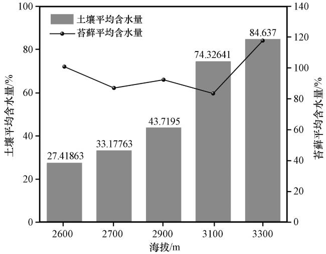
式中: X代表海拔(单位: m); Y表示含水量(单位: %); R 2为回归决定系数; P为显著性检验。
两种回归模型的回归决定系数R 2分别为0.78和0.97, P0.01, 表明相关性和显著性均较好, 表明回归模型和实际拟合接近。
3.2 温度的空间变化特征
温度影响植被和土壤, 进而影响水源涵养功能。分析了空间上气温和土壤温度的变化情况(图4), 表明: 土壤温度随海拔的升高而降低, 整个海拔区间范围内呈线性递减趋势(线性模型系数K=-0.19690), 海拔2800~3300 m的年平均土壤温度分别为: 0.15 ℃、 -0.07 ℃、 -0.58 ℃、 -0.96 ℃、 -1.31 ℃、 -1.66 ℃。可见, 2800~2900 m为土壤平均温度的正负零界点, 2900 m以上土壤年平均温度在0 ℃以下, 2800 m以下土壤年平均温度在0 ℃以上, 海拔上升100 m, 土壤温度平均递减率为0.39%。
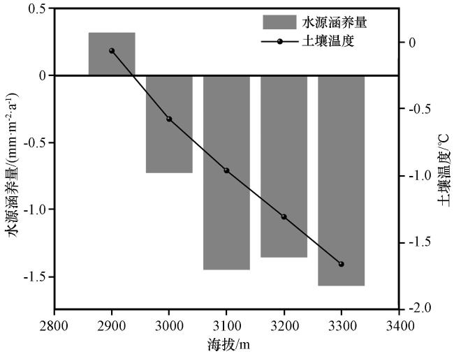
海拔2900 m年平均气温为0.32 ℃, 在0 ℃以上, 其余海拔年平均气温均在0 ℃以下, 分别为-0.73 ℃、 -1.45 ℃、 -1.36 ℃、 -1.57 ℃, 海拔升高100 m, 年平均气温平均递减-0.52 ℃, 气温在海拔2900~3300 m范围内呈二次多项式变化关系, 由此可见, 海拔3000 m以上年平均气温和土壤年平均温度均在0 ℃以下, 生长季较短, 不利于植被生长, 减弱了植被的水源涵养功能。气温和土壤温度的空间变化模型方程为:
式中: X1 和X2 均表示海拔(单位: m); Y1 表示土壤温度(单位: ℃); Y2 表示气温(单位: ℃)。
可以看出两者回归模型R2 值均接近1, P0.01, 表明土壤温度和气温与海拔均有很强的相关性和显著性。
3.3 降水及水源涵养量的空间异质性特征
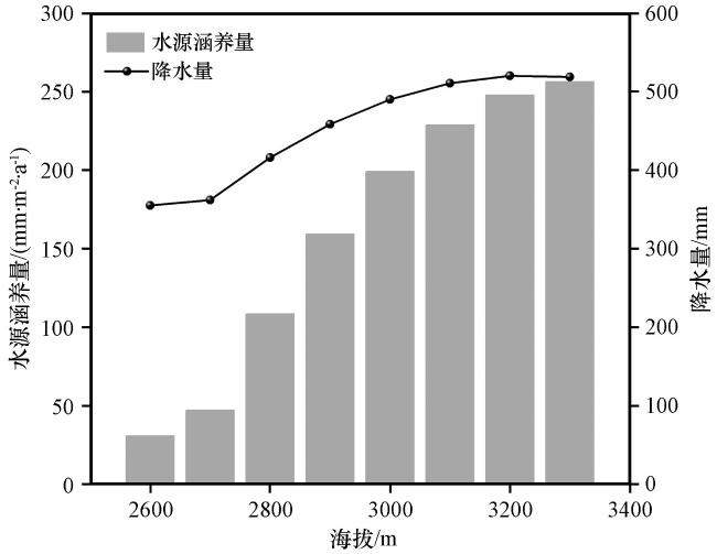
从图5可以看出, 在海拔2600~3300 m区间范围内, 降水随海拔的升高而增大, 水源涵养量也随海拔的升高而增大, 两者在此海拔段均呈显著的二次函数变化趋势, 年降水量在各海拔的累计值分别为: 355.1 mm、 362.0 mm、 415.8 mm、 458.6 mm、 490.1 mm、 510.7 mm、 520.2 mm、 518.7 mm, 体现了明显的波动增加趋势; 在相同海拔区间上单位面积水源涵养量均值为159.63 mm·m-2·a-1, 介于30.62~256.16 mm·m-2·a-1, 水源涵养量在空间的变化趋势与降水具有一致性, 也呈现出随海拔的升高而增大趋势, 不同海拔单位面积年水源涵养量的累计值分别为: 30.62、 47.11、 108.39、 159.16、 199.15、 228.72、 247.69和256.16 mm·m-2·a-1。因此, 祁连山排露沟流域海拔2600~3300 m范围内水源涵养量的最佳变化模型为多项式变化模型, 其模型方程为Y=-0.0003X2 +2.1132X-3465.4, 回归决定系数R2 为0.98, 同时经显著性检验P0.01, 说明该变化趋势非常显著。
3.4 水热因子与水源涵养量的关系
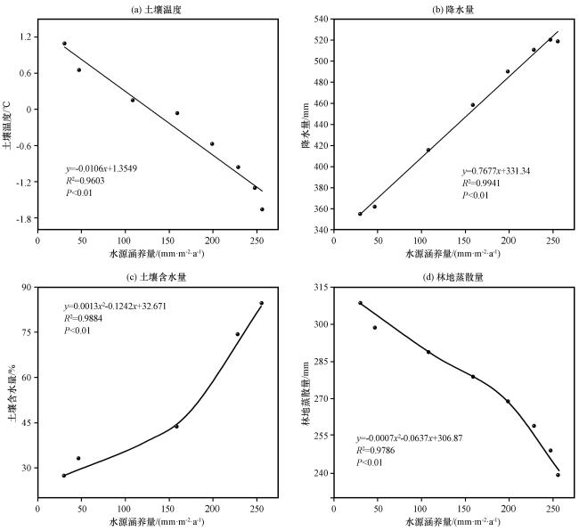
从影响水源涵养功能的主要水热因子入手, 分析降水、 温度、 土壤水分、 蒸散发等多因素对水源涵养功能的影响, 图6为祁连山排露沟流域温度、 降水、 土壤水分、 林地蒸散发与水源涵养量的关系。从图6中可看出: 土壤温度和林地蒸散量与水源涵养量之间呈现极显著的负相关, 相关系数R 2分别为0.96和0.98, 显著性检验均为P0.01。降水量和土壤水分与水源涵养量之间呈现极显著的正相关关系, 相关系数R2 分别为0.994和0.988, 显著性检验均为P0.01(见下表2和图6)。通过相关系数可以看出降水、 土壤水分、 林地蒸散量、 土壤温度均是影响水源涵养功能的因子, 与蒸散发和土壤温度相比降水和土壤水分是主要的影响因子, 与水源涵养量表现为较好的一致性, 祁连山青海云杉分布带降水随海拔的升高而增大, 降水也是土壤水分的直接供给者。因此, 降水、 海拔是影响水源涵养量的首要因子, 从图5可以看出, 2600 m单位面积水源涵养量为30.62 mm·m-2·a-1最小, 是由于此海拔降水量最小所致, 和上述研究结论具有较好的一致性。
图6 祁连山排露沟地温(a)、 降水量(b)、 土壤含水量(c)、 林地蒸散量(d)与水源涵养量的关系Fig.6 The relationships between soil temperature (a), precipitation (b), soil moisture content (c), and evapotranspiration from the forest floor (d) and the amount of water contained in a Qilian Mountain drainage ditch |
表2 水热因子对水源涵养功能影响的回归模型Table 2 Regression model of the impact of hydrothermal factors on water conservation function |
| 影响因子 | 模型方程 | R2 | 显著性检验(P) |
|---|---|---|---|
| 降水 | y=0.7677x+331.34 | 0.994 | P0.01 |
| 土壤水分 | y=0.0013x2 -0.1242x+32.671 | 0.988 | P0.01 |
| 林地蒸散量 | y=-0.0007x2 -0.0637x+306.87 | 0.98 | P0.01 |
| 土壤温度 | y=-0.0106x+1.3549 | 0.96 | P0.01 |
4 讨论
海拔影响温度, 温度影响植被。本研究表明2900 m为土壤温度正负临界点, 2900 m以下土壤平均温度在0 ℃以上, 2900 m以上土壤平均温度在0 ℃以下, 此结论回答了为什么2900 m以下青海云杉林及林下草本、 苔藓等植被生长好的主要原因, 土壤平均温度在0 ℃以上, 土壤中的养分、 水分有利于植被的充分吸收和利用, 土壤处于冻结或半冻结状态, 不利于植被的吸收和利用, 导致植被生长、 分布较差, 因此, 降水和温度是决定植被生长和水源涵养功能的重要因素。
多数研究发现影响水源涵养功能的因素较多, 主要有气候因子、 土地利用(Yang et al, 2021; Yang et al, 2019)等, 土地利用变化会改变土壤条件、 土壤侵蚀和下垫面等情况, 影响入渗、 蒸散、 土壤保水和地表径流等水文过程, 进而影响水源涵养功能。气候因子中主要驱动力是降水, 同时还有研究表明蒸散量和温度对水源涵养量具有明显的抑制作用, 作用程度仅次于降水和土壤水分的促进作用(乔亚军等, 2023), 该结论与本研究结论很类同。根据水量平衡原理, 降水与实际蒸散之间的平衡直接影响区域产水量和水源涵养量, 因此实际蒸散也与水源涵养功能直接相关, 这与国内学者在黄河流域(杨洁等, 2020)得出的结论相似。
本研究发现降水、 土壤温度、 土壤水分和林地蒸散量对水源涵养功能影响较大, 通过拟合和回归等方法分析得出降水、 土壤水分与水源涵养量之间具有显著的正相关关系; 林地蒸散量和土壤温度与水源涵养量之间具有显著的负相关关系。但是各因子对水源涵养功能影响的阈值范围很难确定, 因为影响因子较多, 难以控制, 导致不同环境条件下水源涵养量明显不同, 下一步计划对同一水热条件下和不同条件下的水源涵养量进行对比分析研究, 确定不同因子和水源涵养量的阈值范围, 水热因子为何值时, 水源涵养量最大或最小, 这将是今后研究的核心问题。
5 结论
本研究利用回归拟合模型及水量平衡模型, 对影响祁连山青海云杉林水源涵养功能的主要水热要素进行了深入分析, 得出如下结论:
(1) 苔藓在海拔2600~3300 m的平均含水量分别为100.76%、 86.94%、 92.32%、 83.43%、 117.62%, 变化关系遵循二次多项式。土壤水分平均含量为27.42%、 33.18%、 43.72%、 74.33%、 84.64%, 变化关系遵循显著的指数函数, 苔藓的含水量明显高于土壤, 是土壤的4~5倍, 其吸水、 保水、 存水的作用更为明显, 体现它超强的水源涵养功能。
(2) 海拔2800~3300 m的年平均土壤温度分别为: 0.15 ℃、 -0.07 ℃、 -0.58 ℃、 -0.96 ℃、 -1.31 ℃、 -1.66 ℃。2800~2900 m为土壤平均温度的正负零界点, 2900 m以上土壤年平均温度在0 ℃以下, 2800 m以下在0 ℃以上, 海拔上升100 m, 土壤温度平均递减率为0.39%, 土壤温度随海拔的升高而降低, 变化呈线性递减函数。年均气温在海拔2900 m为0.32 ℃, 其余海拔年平均气温均在0 ℃以下, 分别为-0.73 ℃、 -1.45 ℃、 -1.36 ℃、 -1.57 ℃, 海拔升高100 m, 年平均气温递减-0.52 ℃, 气温在海拔范围内呈二次多项式变化关系。
(3) 水源涵养量均值为159.63 mm·m-2·a-1, 海拔2600~3300 m其值分别为30.62、 47.11、 108.39、 159.16、 199.15、 228.72、 247.69、 256.16 mm·m-2·a-1, 空间变化遵循多项式变化关系。
影响水源涵养功能的水热要素较多, 是各因子共同作用的结果, 本研究重点分析了降水、 土壤温度、 土壤含水量、 林地蒸散量等, 表现为降水和土壤水分与水源涵养量呈现极显著的正相关关系, 回归系数R 2分别为0.994和0.988; 土壤温度和林地蒸散量与水源涵养量呈现极显著的负相关, R2 分别为0.96和0.98。因此, 降水和温度对水源涵养功能具有明显的促进作用, 温度和林地蒸散对水源涵养功能具有明显的抑制作用。