Not found Atmospheric circulation during rainstorm formation

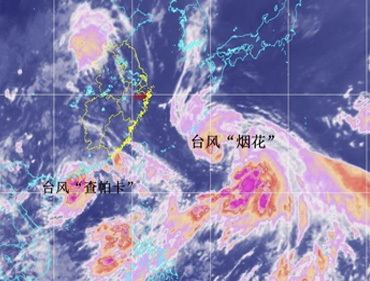
2021年7月20日,河南出现持续性强降水天气,多地出现暴雨、大暴雨,部分地区出现特大暴雨。21日,中央气象台召开媒体通气会,介绍河南暴雨相关情况。据介绍,四大原因导致了河南发生此次罕见暴雨天气。

(1)大气环流形势稳定。西太平洋副热带高压和大陆高压分别稳定维持在日本海和我国西北地区,导致两者之间的低值天气系统在黄淮地区停滞少动,造成河南中西部长时间出现降水天气。

(2)水汽条件充沛。7月中旬河南处于副高边缘,对流不稳定能量充足,18日西太平洋有台风“烟花”生成并向我国靠近。受台风外围和副高南侧的偏东气流引导,大量水汽向我国内陆地区输送,为河南强降雨提供了充沛的水汽来源,降水效率高。

(3)地形降水效应显著。受深厚的偏东风急流及低涡切变天气系统影响,加之河南省太行山区、伏牛山区特殊地形对偏东气流起到抬升辐合效应,强降水区在河南省西部、西北部沿山地区稳定少动,地形迎风坡前降水增幅明显。

(4)对流“列车效应”明显。在稳定天气形势下,中小尺度对流反复在伏牛山前地区发展并向郑州方向移动,形成“列车效应”,导致降水强度大、维持时间长,引起局地极端强降水。

这次河南省郑州市6小时降雨382 mm,其中20日16:00—17:00 1小时降雨量超过200 mm,由于降水持续时间比较长,且强降水发生的区域比较集中,造成河南省西部、西北部山区山洪地质灾害风险明显增高,黄河流域、海河流域中小河流水库水位迅速上涨;另外还造成了大范围城市内涝、农田积涝,给群众生活生产等造成较大影响,引起了各界关注。

关于暴雨天气过程在20世纪中叶就引起了国内研究人员的广泛关注,并取得了一系列研究成果,为了使大家更清晰地了解这些研究成果,更客观地认识暴雨天气的形成过程,《高原气象》特整理了“暴雨形成过程”的系列虚拟专刊,以供大家参考。


Default Latest Most Read  
Please wait a minute...
For Selected: Toggle Thumbnails
  • Change Properties of Summer Extreme Precipitation Events and Temperature and Associated Large-Scale Circulation in China during 1960-2009
  • CHEN Jinming;LU Guihua;WU Zhiyong;GU Shixiang;HE Hai
  • 2016, 35 (3): 675-684. DOI: 10.7522/j.issn.1000-0534.2015.00072
  • Abstract (789) PDF (7821KB)(617)
  • Climate simulations have suggested that a greenhouse-gas induced global warming would also lead to a moistening of the atmosphere and an intensification of the mean hydrological cycle.Such a change can contribute directly to changes in regional precipitation climate,so there is an ongoing interest in the possible relationship between temperature and extreme precipitation events(EPE).The relationship between summer temperature and extreme precipitation events was studied using Singular Value of Decomposition(SVD)method based on the daily precipitation and temperature data of the 610 meteorological stations in China and NCEP/NCAR reanalysis data from 1960 to 2009,the difference of their corresponding change in atmospheric circulation was also analyzed.Results show that there exists a significant correlation between EPE and temperature in China that a positive correlation in northwest and southern areas but a negative correlation in the northeast to southwestern areas.Abrupt summer temperature and EPE change both emerged around 1992,an abnormal continental cyclonic circulation whose center in Mongolia existed in 850hPa wind fields during pre-mutation(1960 1992),however, abnormal continental cyclonic circulation translated to anticyclonic circulation during later mutation(1993-2009).This abnormal cyclonic(anticyclonic)would strengthen(weaken)the cold air invasion southward,resulting in higher temperature of the later mutation.During pre-mutation,western and southern China were respectively influenced by abnormal western and southwestern water vapor transportation,water vapor was abnormal divergence and resulted in less EPE.However,northeast to southwest areas were affected by abnormal southwestern water vapor transportation,water vapor was abnormal convergence and leaded to more EPE.The situation was just opposite after mutation.
  • Mechanism Analysis of a Rainstorm Occurred in the Eastern Part of Northwest China
  • WANG Fucun;XU Dongbei;XIU Shaoyu;QUE Longkai;HAN Shupu;GUO Pingping;ZHENG Xuejin
  • 2014, 33 (6): 1501-1513. DOI: 10.7522/j.issn.1000-0534.2013.00104
  • Abstract (490) PDF (10866KB)(754)
  • By using the data of sounding and surface intensive AWS, the satellite cloud images and the reanalysis data of NCEP 1°×1°, the forming mechanism of a rainstorm occurred on 23 July 2010 in the eastern part of Northwest China are analyzed. The results show that the eastern part of Northwest China is at the left side of exit zone of the upper level north jet and convergence region of the low vortex and shear-line in the low level, so the coupling of the upper and low level system is easy to form strong ascend movement. The low level southerly air current formed by interaction of typhoon ‘Chanthu' and the subtropical high continuously transports water vapor to the eastern region of Northwest china. During the rainstorm, precipitation rate and rainfall intensity is consistent and the precipitation rate is over 50 mm·h-1 in the strongest period of rainstorm. Under the background of the saddle pattern flow field, the cold and warm air converge in shear lines of the low vortex. The great total deformation zones coincide with the dense belt of equivalent potential temperature isoline, it is conducive to enhance the wet baroclinicity of the low vortex. During the rapid development of the vortex, the vertical vorticity growth mostly come from the twisting term on 500 hPa. The twisting term maximum ahead of vertical vorticity maximum appears, which has the very good instruction significance for rainstorm forecast. The smaller the negative center value of non-equilibrium force of atmospheric motion on 850 hPa is, the stronger the raininess will be.The negative center value of non-equilibrium force of atmospheric motion in the extreme precipitation region is below -10.0×10⁻⁹s-2.
  • Climate Intraseasonal Oscillation of Heavy Rainfall Process and Its Application in Extend-Range Forecast
  • 梁萍;丁一汇
  • 2013, 32 (5): 1329-1338. DOI: 10.7522/j.issn.1000-0534.2012.00125.
  • Abstract (503) PDF (1005KB)(932)
  • Low frequency oscillations (LFO) with periods over 10 d under intraseasonal scale are important means for extend-range forecast becauseof its relative longer predictabilitythan synoptic scale perturbation with high frequency. In this paper, taking Shanghai as an example, using the daily rainfall observation in Shanghai and global NCEP/NCAR reanalysis atmospheric circulation data for the period of 1960-2010, climate intraseasonal oscillation (CISO) of heavy rainfall process (HRP) in Shanghai is firstly investigated by means of a new kind of nonlinear serial signal processing method named as EEMD (Ensemble Empirical Mode Decomposition). And forecast effects on HRP basing on CISO are then evaluated. Finally, improvement experiments are tested by combining CISO of HRP and their relating LFO of atmosphericcirculation. The results show that: (1) Positive (negative) phases of LFO with periods over 30d are consistent with active (break) periods of HRP during rainy season. While LFO with 10~30 d periods can not only modulate occurrences of HRP during the two active periods but also do contribution to severe rainfall stage during mid-summer. (2) 2/3 HRP occurrences during rainy season can usually be predicted basing on CISO of HRP, which may be an important clue for its extend-range forecast. (3) HRP in Shanghai usually isin close association with LFO convergences under both 10~30 d and over 30 d intraseasonal scale from both south and north directions. The LFO of west Pacific subtropicalhigh and north systems exert important influences on continuous HRP lasting for more than 5 d. And the forecast effects can be improved by combining CISO of HRP and their relating LFO of atmosphericcirculation, which may be a kind of means with certain value in practice of extend-range forecast.
  • Teleconnection between Summer Extreme Precipitation Event of East Part of Northwest China and Pacific SSTA
  • YANG Jin-hu;JIANG Zhi-hong;BAI Hu-zhi
  • 2008, 27 (2): 331-338.
  • Abstract (286) PDF (1689KB)(543)
  • Using the height field, wind field of monthly mean NCEP reanalysis NOAA reconstruct sea surface temperature, daily precipitation data of 38 stations in east part of Northwest China in recent 50 years, and with SVD, composite analysis methods, the Pacific SSTA effect on extreme precipitation event of east part of Northwest China are researched. The result show that there are remarkable relations between winter Pacific SSTA and anaphase summer extreme precipitation event of east part of Northwest China, and equator middle-east Pacific Ocean is key area which affect to summer extreme precipitation event of east of Northwest China, when the winter SST occurs anomaly phenomenon in the equator middle-east Pacific Ocean, at first longitudinal and latitudinal departure circulation cells occur anomaly, then general circulation occurs adjustment, successively west Pacific subtropic high pressure also arise anomaly by PNA and WP from winter to summer, finally summer extreme precipitation event of east part of Northwest China occur anomaly phenomenon.
  • Rainstorm and Flood Disaster Characteristics and Analysis of Circulation Background in Main Flood Season in Sichuan
  • DENG Guowei;SUN Jun;RUAN Guibin;MA Zhenfeng
  • 2017, 36 (6): 1521-1532. DOI: 10.7522/j.issn.1000-0534.2016.00099
  • Abstract (634) PDF (11814KB)(804)
  • Using the investigation data of heavy rainstorm-induced economic damage in Sichuan province area during 1984-2010, the characteristics of rainstorm-induced flood disaster in the last 30 years were studied. The population exposure and vulnerability index have been derived and used to do potential analysis of flood and economy damage. The disaster associated rainstorm was analyzed with the gauge stations observed daily rainfall data from China Meteorological Agency (CMA). Then we analyzed the atmospheric circulation for the heavy rainstorm which has caused flood and economic damage for Sichuan province using National Centers for Environmental Prediction (NCEP) reanalysis data from June to September (the main rainfall and rainstorm seasons) during 1981-2010. The results showed that the population affected due to rainstorm and flood disaster was increased during last 30 years. The increasing rate was more significant after the year of 1999. The population and economy potential damage analysis show that Chengdu city has a high exposure index value, but with a low vulnerability index. The exposure index of Ganzi/Aba area was the lowest in the province. The big city has a high population intensity influenced by the flood disaster, while the undeveloped area has a low population disaster intensity. The indices of population vulnerability and economic vulnerability of Sichuan were shown with an oscillation period of 2 years. The impact of heavy rains and flooding on Mianyang and Bazhong city, which was located in the rainstorm center of Sichuan province would be further exacerbated, and the cities, whose indices of population vulnerability and economic vulnerability were among the forefront of the province were mainly located in East Sichuan Area. In addition, circulation background characteristics of heavy rain in main raining seasons was analyzed to show that:South Asian High was "Western-type" and its intensity was weaker than annual average; Subtropical High was showed with a significantly quasi biweekly oscillation from July; Atmospheric circulation of the middle and upper troposphere in East Asia has a low frequency oscillation of 20~30 days in the mid-high latitude; Plateau vortex was showed with about 22 days of the oscillation cycle and Southwest flow in low latitudes was continuously transported to high latitudes. The flood associated heavy rainstorm maybe closely related these atmospheric circulation patterns.
  • Dominant Spatial Patterns of Summer Precipitation and Circulation Characteristic in the Middle of Northwest China
  • SHEN Hongyan;CHEN Lijuan;HU Po;QIAO Shaobo;ZHANG Tiaofeng
  • 2017, 36 (2): 455-467. DOI: 10.7522/j.issn.1000-0534.2016.00139
  • Abstract (471) PDF (29470KB)(899)
  • Based on the 55 stations data in the middle of Northwest China and NCEP/NCAR reanalysis dataset, the dominant modes of summer precipitation anomalies over the middle of Northwest China and corresponded circulation characteristic, water vapor transportation conditions were analyzed by diagnostic methods.There are three dominant EOF modes about summer rainfall.The first mode showed the same anomaly in whole region.The second showed an inverse pattern between the east and west.The third showed the opposite anomaly between the south and north.Further analysis were shown that the dominant precipitation EOF modes had different circulation and water vapor condition features.For EOF1 positive phase, the center of subtropical westerly wind was eastern to its normal position, Ural blocking high usually stronger than normal, water vapor transportation originates from Bay of Bengal, South China sea and west tropical Pacific.The water vapor convergence was significant in the middle of Northwest China.The EOF2 mode was connected with 'silk road' teleconnection pattern circulation.For the more rainfall in east and less in west pattern, the enhanced anticyclone circulation over central Asia provided strong cold air.And the anticyclone circulation anomaly in Northwest Pacific provided strong transport water vapor to the middle-west regions of China.A significant convergence was formed in the east part of Gansu province.The EOF3 mode was deeply affected by the middle-high geopotential height pattern.When rainfall anomaly was positive in south and negative in north, the circulation showed 'North-high and South-low' pattern over Eurasia.This mean a strengthened trough over Baikal which provides the strong westerly anomalies to the south of Baikal.At the same time, the vapor transformation originated from the Bay of Bengal, and further move to the east side of Tibet.A clear convergence formed in the southern of Qinghai province.From the above analysis, it showed significant differences about cold air conditions and the source of water vapor of the three dominant modes of summer precipitation in the middle of Northwest China.
  • Spatiotemporal Characteristics of Summer Rainstorm Days in Gansu Province and Their Relationships with the Atmospheric Circulation
  • HUANG Yuxia;WANG Baojian;WANG Yanfeng;HUANG Wubin
  • 2017, 36 (1): 183-194. DOI: 10.7522/j.issn.1000-0534.2015.00118
  • Abstract (601) PDF (32398KB)(823)
  • Because of characteristics of summer rainstorm easy to form disasters, difficultly to forecast, so it has been the focus of the study.Gansu province is located in the upper reaches of the Yellow River, the region at the confluence of the Loess Plateau, the Inner Mongolia Plateau and the Qinghai-Tibet Plateau.Climate type variety are complex, special geographic location and significant spatial variation of precipitation make forecast exceedingly difficult in Gansu province.Previous studies are mostly for the heavy rainstorm, rarely studied the characteristics of the rainstorm days change, but the rainstorm days is also an important indicator of climatic characteristics of heavy storm days in Gansu province.In order to study climate change characteristics and laws of the rainstorm, improve the accuracy of the rainstorm forecast, using daily precipitation data at 80 stations in Gansu Province, NCEP/NCAR reanalysis datasets during 1974-2013, and following empirical orthogonal function, system clustering and composite analysis method, the spatial and temporal variation characteristics of rainstorm days during summer in Gansu province and their relationships with the atmospheric were studied.The results showed that:Rainstorm days in Gansu province experienced three significant interdecadal variation process in recent 40 years during summer around 1989、2002、2009.According to the EOF and cluster analysis, the summer rainstorm days were divided into four distribution patterns, namely the Hedong strong and Hexi weak pattern, Gansu mountain of Minxian pattern, Longnan and Longdong pattern, the whole province pattern.The summer rainstorm days were closely related to the East Asian summer monsoon in the South China Sea with more available moisture.The Hedong strong and Hexi weak pattern and Longdong and Longnan pattern were related to the movement of cold wave.The Hedong strong and Hexi weak pattern corresponded to strengthen with cold vortex of Lake Baikal, cold air south, the monsoon with its position by northwest, moisture from the South China Sea and the East China sea transporting to east.The Gansu mountain of Minxian pattern pattern corresponded to the monsoon with its position by north, moisture from the South China Sea and the Bengal bay transporting to west and meeting in Gannan region.The Longdong and Longnan pattern corresponded to Iran high and Mongolia low weaken, cold air activity reducing, the monsoon with its position by south, moisture from the South China Sea transporting to southeast, cold air backflow more likely to resulted in forming precipitation in Longdong and Longnan region.The whole province pattern corresponded to the monsoon with its position by the Tibetan plateau, moisture from the South China Sea and the Bohai Sea transporting to westwards extending and northwards advancing that impacting most regions of Gansu Province.
  • Characteristics of Climate Change of Summer Rainstorm in Sichuan Basin in the Last 53 Years
  • CHEN Dan;ZHOU Changyan;XIONG Guangming;DENG Mengyu
  • 2018, 37 (1): 197-206. DOI: 10.7522/j.issn.1000-0534.2017.00022
  • Abstract (751) PDF (2177KB)(1331)
  • Based on the observed daily precipitation data and NCEP/NCAR reanalysis data from 1960 to 2012, the temporal and spatial variation of rainstorm in Sichuan Basin were discussed, and the water vapor transport, atmospheric circulation and sea surface temperature anomaly in the west and east of the Basin were analyzed by using the composite anomaly, correlation analysis, wavelet analysis and so on. The main conclusions are as follows:The rainstorm frequency and rainstorm amount showed the opposite changes in the east and the west of Sichuan Basin, the rainstorm increased in the west and decreased in the east, there was a significant positive correlation between rainstorm precipitation and frequency. The rainstorm in the west of Sichuan Basin was extremely more in 1960s and 1980s, while abnormally less in 1990s and early 21st Century, which mainly existed a 6~7 years inter-annual oscillation period in 1960s and from the mid-1980s to the end of the 1990s. The rainstorm in the east of Sichuan Basin was obviously less in 1960s and 1970s, while abnormally more in 1980s, 1990s and early 21st Century, which significantly existed 8~9 years inter-annual oscillation period and 14~15 years inter-decadal oscillation period from the beginning of 1970s to the beginning of 1990s. When the West Pacific Subtropical High shifts northward and become stronger, the Western Pacific water vapor will be more easily transported to the west of Sichuan Basin. These lead to rainstorm in the west of Sichuan Basin. By contrast, when the West Pacific Subtropical High shifts southward, the Western Pacific water vapor will be transported to the east of Sichuan Basin; under the situation of blocking pattern in the west of Lake Baikal, the southward moving path of the cold air tend to the east, so the cold air and warm wet air converge in the east of Sichuan Basin, cause more rainstorm in the east of the Basin. The rainstorm in west Sichuan Basin shows significant negative correlation with the West Pacific Warm Pool and ENSO events. The relationship between rainstorm and sea surface temperature in the east of Sichuan Basin is much weaker than in the West.
  • Relationship between Summer Monsoon Changes in East Asia and Abnormal Summer Rainfall in North China
  • HAO Lisheng;DING Yihui;MIN Jinzhong
  • 2016, 35 (5): 1280-1289. DOI: 10.7522/j.issn.1000-0534.2015.00085
  • Abstract (620) PDF (4434KB)(1063)
  • To find out the causes of abnormal summer rainfall in North China and to improve climate prediction technologies, a comprehensive analysis on the relationship between East Asian summer monsoon and summer precipitation in North China is carried out in this paper by defining the index of East Asian summer monsoon with the meridional wind field and based on such data as summer precipitation in North China and general atmospheric circulation reanalyzed by NCEP/NCAR. The results of the analysis indicate that:1) North China has more summer rainfall during strong East Asian summer monsoon years but less summer rainfall during weak East Asian summer monsoon years. An opposite case also exists. The spatial distribution pattern of more (less) rainfall in East Asian strong summer monsoon years is significantly different from that of more (less) rainfall in weak East Asian summer monsoon years. (2) Irrespective of strong or weak East Asian summer monsoon years, the circulation conditions contributing to more summer rainfall in North China are sufficient water vapor sources (strong summer monsoon years:abnormal water vapor carried by southwest wind; weak summer monsoon years:abnormal water vapor carried by southeast wind) and good dynamic conditions (with convergence circulation at 850 hPa in North China, prominent zonal circulation at 500 hPa at middle latitude, and more low-pressure trough transit in North China). (3) The circulation pattern related to less summer rainfall in North China is significantly different:No effective dynamic conditions (with divergence circulation at 850 hPa in North China, prominent meridional circulation at 500 hPa at middle latitude, and less low-pressure trough transit in North China) are created both in strong summer monsoon years with sufficient water vapor sources (abnormal southwest wind) and weak summer monsoon years with insufficient water vapor sources (abnormal northerly wind). (4) Although there are sufficient water vapor sources in strong East Asian summer monsoon years, the summer rainfall differs a lot in different years in North China due to diverse dynamic conditions. If the dynamic conditions are good, North China will have abnormally more summer rainfall; otherwise, it will also have abnormally less summer rainfall. (5) In weak East Asian monsoon years, water vapor carried by southwest wind is reduced significantly, so North China will have abnormally less summer rainfall if there is lack of water vapor supplement from other paths and the dynamic conditions are poor. Although water vapor carried by southwest wind is reduced significantly in weak summer monsoon years, sometimes there are also sufficient water vapor sources in North China if more water vapor is carried by southeast wind. At the same time, if the dynamic conditions are good, North China may also have abnormally more summer rainfall, as the case during 2011 2013. In terms of the prediction of summer rainfall in North China, it cannot be simply considered that North China will have more summer rainfall in case of strong East Asian summer monsoon or will have less summer rainfall in case of weak East Asian summer monsoon, as the intensity change of East Asian summer monsoon only suggests different water vapor conditions. The summer rainfall in North China can only be well predicted after the dynamic conditions are also considered.
  • Frontogenesis Process and Slantwise Vorticity Development of a Rainstorm Process in the Eastern Gansu
  • WANG Fucun;XU Dongbei;YAO Yanfeng;XIU Shaoyu;GUO Pingping;QUE Longkai;HAN Shupu
  • 2016, 35 (2): 419-431. DOI: 10.7522/j.issn.1000-0534.2014.00127
  • Abstract (634) PDF (10767KB)(919)
  • By using the data of sounding and surface intensive AWS, the satellite cloud images, the Doppler weather radar and the reanalysis data of ECMWF (ERA-interim) 0.25°×0.25°, the frontogenesis process and slantwise vorticity development of a rainstorm occurred on 20 June 2013 in the eastern Gansu are analyzed. The results show that the strong frontogenesis is caused by interaction among the shear line in lower troposphere, subtropical high, and the cold air in the middle and lower troposphere in the northeastern side of the plateau. The frontogenetical forcing causes rapid development of vertical vorticity and convergence in the shear line, triggering the release of unstable energy to generate strong convection and rainstorm. The rainstorm occurs beneath strong convective cloud of TBB<-52℃. Rain intensity changes from weak to strong with the cold air southward invading and infiltrating in the eastern Gansu, however, that begins to weaken after entering the Sichuan. The height of radar strong echo is below 5 km and 0℃ layer, it has characteristics of low center of mass and high efficiency precipitation echo. The strong echo moving from south to north has the train effect. The intensity changes of frontogenesis, shear line and rainfall are consistent. The frontogenesis function analysis indicated that enhancement stage in the rainstorm, effects of divergence and deformation play the main role and effect of deformation is more obvious, however, effect of tilting term is relatively small. The continuous stage in the rainstorm, effects of divergence and deformation are equal in match or contest of strength, effect of tilting term is frontolysis. Through the complete form of vertical vorticity tendency equation established the direct connection between the vertical vorticity change and frontogenesis, to diagnose the frontogenesis effect on the intensity of the weather system. The frontogenesis tilts the wet isentropic surface and produces significant positive vertical vorticity change in front of the frontal zone, which results in the fast development of shear line.
  • Impact of the Position Abnormalities of East Asian Subtropical Westerly Jet on Summer Precipitation in Middle-Lower Reaches of Yangtze River
  • KUANG Xue-yuan;ZHANG Yao-cun
  • 2006, 25 (3): 382-389.
  • Abstract (544) PDF (658KB)(896)
  • An axis index of the East Asian subtropical westerly jet is defined as the mean location(latitude) of the 200 hPa maximum westerly at various longitudes over East Asia using the NCEP/NCAR monthly reanalysis data.The indexcan reasonably reflect the interannual variation of the meridional migration of the East Asian subtropical westerly jet and its impact on the precipitation in the middle-lower reaches of the Yangtze River.Moreover,the index has good correspondence with the East Asia summer monsoon and its interdecadal and interannual changes are consistent with the variations of the rainfall in the middle-lower reaches of the Yangtze River.Comparisons of the circulation differences of the East Asian westerly jet position anomalousyearsshow that when the jet is abnormally northward,the intensity of South Asian high is weaker and the location is far north-westward;and the intensity of the western Pacific subtropical high is weaker and its position is far east-southward in comparison with normal condition.As a result,the anomalous convergence areas of air flows migrate to the regions over the North China,which results in more precipitation there.While the jet is abnormally southward,the South Asia high is too strong and far south-eastward,and the western Pacific subtropical high is stronger and far west-southward,resulting in stronger convergent and ascending flows over the Yangtze River valley,which can easily lead to heavy precipitation and floods.
  • Analyses of Atmospheric Circulation of Tropical Indian Ocean Basin Mode Influencing Precipitation in East of Northwest China
  • YANG Jianling;ZHENG Guangfen;WANG Suyan;MU Jianhua;WANG Min;TIAN Lei
  • 2015, 34 (3): 700-705. DOI: 10.7522/j.issn.1000-0534.2014.00011
  • Abstract (534) PDF (4100KB)(786)
  • Our previous study shows that since mid 1970s the persisting anomaly of the tropical India Ocean Sea Basin Mode (IOBM) in previous winter and spring is significantly corrected with precipitation anomaly main mode in the East of Northwest China (ENC) in subsequent May. In this study, using regression method, the atmospheric circulation anomaly and possible mechanism of the IOBM influencing on precipitation in ENC are studied. It is found that the warming IOBM can induce the responding of 'Matsuno-Gill Pattern' in the atmosphere and form the wave train over area from the tropical Indian Ocean to Europe to Asia at middle to upper troposphere level. The anomalous values of wave train increase with height increasing. ENC is just located between the negative center of Xinjiang to Balkhash Lake and positive center of East Asia, and just controlled by the pattern of ‘West Low and East High’, which is the typical circulation pattern of more precipitation in ENC. Corresponding to the wave train of height anomaly, there are three significant cyclone and anticyclone anomaly centers over Europe-Asia area. At upper level of 200 hPa, it is the large scale wind divergence anomaly over area from North China to ENC, and at lower level of 850 hPa it is the convergence over there. Concerned with the divergence at upper level and convergence at lower level, it induces the vertical ascending, which is advantage of more precipitation. The vertical ascending motion center is over area from North China to ENC. So it is said that the IOBM can influence the precipitation anomaly over ENC by inducing the wave train over Europe to Asia area at middle-upper troposphere, and informing anomaly circulation pattern of 'West Low and East High' over ENC. For the cold case of IOBM, it is vise verse.
  • Possible Linkage between Winter Surface Sensible Heat Flux Anomalies over the Mid-High Latitudes of the Eurasian Continent and Summer Precipitation in the Eastern Part of Northwest China
  • PANG Xueqi;LI Dongliang;YAO Huiru
  • 2017, 36 (3): 675-684. DOI: 10.7522/j.issn.1000-0534.2016.00054
  • Abstract (578) PDF (830KB)(862)
  • On the basis of daily precipitation observations at 156 stations from 1979 to 2012 in eastern part of Northwest China and the monthly means of surface sensible heat flux of NCEP/DOE reanalysis data, physical mechanism and possible linkage between winter surface sensible heat flux anomalies over mid-high latitudes of the Eurasian Continent (61°N-67°N, 53°E-68°E) and summer precipitation over eastern part of Northwest China are analyzed in this study. The results show that when the sensible heat flux over mid-high latitudes of the Eurasian Continent transported from atmosphere to land surface is larger in winter, the sensible heat flux transportation from land surface to atmosphere will be larger in spring and summer as a consequence, the Ural blocking high and Mongolian low are strengthened, the northwest Pacific subtropical high is strengthened and migrating more west than normal, the subtropical westerly jet is anomalously northward and the South Asian high is far eastward, resulting in the ascending flow over eastern part of Northwest China strengthened. In addition, the transportation of the warm and moist air flows in low-level are strengthened in eastern part of Northwest China, as well as the water vapor convergence. All these contribute to the precipitation increasing over Eastern Part of Northwest China because of its location at the bottom of the Mongolian low and to the northwest of the subtropical high, in contrast, when the sensible heat flux transported from atmosphere to the surface is smaller in winter, the sensible heat flux transportation from land surface to atmosphere will also be smaller in spring and summer leading to the opposite atmospheric circulation anomalies in the summer, which will make the summer precipitation over the eastern part of Northwest China decreasing.
  • Analysis on General Circulation Anomalies of the Extensive Heavy Rains in Guangxi in Last 50 Years
  • QIN Weijian;LI Dongliang;WANG Hui;QIN Zhinian
  • 2014, 33 (2): 515-521. DOI: 10.7522/j.issn.1000-0534.2013.00020
  • Abstract (505) PDF (3186KB)(828)
  • Basing on the daily precipitation data at 90 stations in Guangxi and the NCEP/NCAR reanalysis data during 1961-2010, the characteristic of the atmospheric circulation anomalies of the heavy rains in Guangxi in the past 50 years were analyzed by using Lorenz circulation decomposition method. The deviation index H*, Ic and Ius for global (local) stationary waves are used to analyze the stationary wave anomalies in the extensive heavy rains. The results show that: In recent years, the occurrence of the extensive heavy rain processes exhibit an increasing tendency. The extensive heavy rainfall processes caused by the different weather systems with the different location and intensity of the subtropical high. There is an obvious positive correlation between the extensive heavy rain processes and the intensity of the subtropical high and the H* of the region(130°E-140°W,70°N-90°N)over Arctic Ocean, the negative correlation with the H* of the Northern Greenland and the Midwest Equatorial Indian Ocean and the Northeast Kazakhstan. The strengthen of Ic of the latitudinal bands (75°N-85°N) and (20°N-30°N), Ius of the latitudinal bands (10°N-30°N) and (35°N-55°N). The weaken of Ic of the latitudinal band (40°N-70°N). All these may be the causes of the increasing of the extensive heavy rainfall processes. There always is a most high value zone of Ius near the Arctic in the extensive heavy rainfall processes in Guangxi.
  • Relationship between Flood Period Precipitation in Chongqingand Previous Circulation Anomaly in Southern Hemisphere
  • 周浩;唐红玉;程炳岩;韩世刚;刘晓冉
  • 2011, 30 (1): 174-181.
  • Abstract (263) PDF (985KB)(1339)
  • Usingtheflood period(June~August) precipitation data of 34 stations inChongqingand 96 stations in Southwest China and two kinds of the monthly mean reanalysis data of NCEP/NCAR from 1960 to 2006 and ECMWF from 1958 to 2001, the relationship between flood period precipitation in Chongqing and circulation anomaly in Southern Hemisphere is studied. The results show that there is significant relationship between circulation anomaly from January to May athigh latitude in Southern Hemisphere(40°~60°S) and the flood period precipitationin Chongqing. On the basis of them the preceding factor which can diagnosethe flood period precipitation anomaly in Chongqing to be defined. The negative correlationbetween the preceding factor and flood period precipitation is noticeable. When the preceding factor is high, the flood period precipitation in Chongqing is less; conversely,the preceding factor is low, the precipitation is more.
  • The Characteristics of Summer Precipitation in China since 1981and its Relationship with SST and Pre-circulation
  • Qifen LI;Zhehong WU;Xingju WANG;Donghai ZHANG;Mei XIAO
  • 2020, 39 (1): 58-67. DOI: 10.7522/j.issn.1000-0534.2018.00148
  • Abstract (896) HTML (602) PDF (2951KB)(367)
  • The characteristics of summer precipitation in China from 1981 to 2017 and its relationship with SST and pre?circulation in global were discussed using the NCEP reanalysis data and the monthly mean precipitation data of 160 stations in China based on EOF, Mann?Kendall, wavelet analysis and SVD analysis.The results show that, the first EOF mode of summer precipitation in China had the characteristics of uniform regional and interdecadal changes, the second EOF mode had the characteristics that the northeast in China and the other regions was opposite and had interannual changes.Summer precipitation especially in the Inner Mongolia area from 1981 to 1997 was relatively less than that from 1998 to 2017, while during 2014 -2017 compared with 1998 to 2013, summer rainfall in south of China was more than in north.Summer precipitation in the northern regions and the Yangtze River basin changed suddenly in 1997, while the south’s changed suddenly in 2013 .The north had 26 ~ 30 years, 9 ~11 years and 5 ~ 6 years, the south had 20 ~ 22 years, 12 ~ 13 years, and the Yangtze River Basin had 16 years, 6 ~ 10 years of periodic changes.In the context of interdecadal variation, summer precipitation in China was also interannual variation.SST of the East Pacific in winter was negatively correlated with the Western Pacific Ocean, the India Ocean and the Atlantic and this had interdecadal variation, and that led to a consistent and interdecadal change of the next year’s summer precipitation in China.While SST of the Eastern Pacific, the Indian Ocean, the western Atlantic in winter was inversely correlated with the Western Pacific and the Northeastern Atlantic and this had inter?annual changes, that led to the north?south inversion of the next year’s summer precipitation.SST affected the next year’s summer rainfall by influencing atmospheric circulation such as sea level pressure, 500 hPa height field.Through the continuous observation of the atmospheric circulation in the key area in winter and in spring, it can be used as one of the bases for predicting summer precipitation in the next year.
  • Research of JJA Precipitation Anomaly in Yangtze River Basin Since 2000
  • LIU Yan-xiang;ZHAO Zhen-guo;ZHU Yan-feng;WANG Jian-ping;CHEN Li-hua
  • 2008, 27 (4): 807-813.
  • Abstract (227) PDF (625KB)(506)
  • Based on JJA rain pattern since 1880, the Meiyu and the JJA rain anomaly features in the mid-and lower-reaches of Yangtze River after 1890 and the circulation background at 500 hPa in NH after 1951 are researched by physical statistical methods. The results show that, in summer from 1950's to 1970's, the main rain belts were located in Yellow River basin and North China and Yangtze River basin were dry, or the Meiyu in the mid-and lower-reaches of Yangtze River were poor. Then, during the end of 1970's to end of 1990's, the JJA rain wet belts were moved southwards to Yangtze River basin, and had good Meiyu, but in Yellow River basin and North China were dry. Again then, since 2000, in Yellow River basin and North China were still dry, main rain belts moved back and forth between Huaihe River basin, South China. Obviously the dry climate appeared Yangtze River basin and had frequently poor Meiyu. The synchronized abnormal phenomenon was quite rare in history, which keep the frequent drought in Yangtze River and Yellow River basin and North China. The special configuration of summer circulation in East Asia, was one of main causes keeping the dry climate in Yangtze River basin, it was difference from circulation before 2000.