

1 引言
暴雨是四川盆地最严重的气象灾害, 也一直是极端天气研究的热点。尤其是盆地周边山地突发性暴雨, 作为一种强对流天气, 因其来势猛, 雨强大, 历时较短等特点(郁淑华等, 1997; 肖递祥等, 2012), 成为灾害性天气预报的难点。
暴雨的产生, 需要一定的大尺度环流背景, 已有的研究表明四川盆地东部暴雨多发生在南亚高压偏南、 偏弱, 西太平洋副热带高压偏南, 西风槽的位置偏东, 贝加尔湖多为阻塞形势的背景下(陈丹等, 2018; 李娟等, 2016; 蒋兴文等, 2008)。在影响暴雨的天气系统中, 低空急流与暴雨发生的关系十分密切, 二者的相关系数约达0.8(陶诗言等, 1979)。低空急流不仅是强降水事件的水汽输送通道(Findlater, 1969; Saulo et al, 2007), 而且对暴雨也有触发作用(孙淑清等, 1980; 陈静等, 2002; 张芹等, 2018)。低空急流的建立和维持在动量和热力不稳定能量的输送中起十分关键作用(翟国庆等, 1999; 闵文彬等, 2003; 师锐等, 2015; 顾清源等, 2009), 不仅可使暴雨区局地辐合与气旋性涡度增强, 加速垂直上升(吴海英等, 2010), 并与其他天气系统配合为中尺度系统的产生和发展提供有利条件(曾勇等, 2018)。由于影响降水的因素往往不仅限于大气内部, 地形作用不容忽视, 因此国内外学者开展了大量的研究。国外学者已利用地形高度和坡度作为预报因子诊断地形和降水的关系(Spreen, 1947; Danard, 1977; Basist et al, 1994), 国内学者对地形的研究主要体现在以下两个方面: 其辐合抬升对暴雨的增幅作用十分明显(丁一汇等, 1978; 孙建华等, 2002; 肖递祥等, 2015; 邓承之, 2016), 地形可作为中小尺度对流系统的触发机制, 有利于中尺度涡旋和中尺度对流系统的形成(陶诗言, 1980; 何光碧, 2006)。四川盆地西接青藏高原, 南为云贵高原, 东邻巫山, 北有秦岭、 大巴山, 特殊的地理位置和复杂的地形环境使对其研究具有应用价值。以往研究地形对四川盆地暴雨的影响多针对青藏高原大地形和秦巴山区, 其中高原的动力阻挡作用会影响四川盆地暴雨的水汽输送通道及西南涡的形成(李川等, 2006; 姜永强等, 2010), 高原东侧陡峭的地形加强了辐合流场和气流的垂直上升运动(李川等, 2006)。秦巴山区则主要通过形成局地环流, 使得西南暖湿气流带来的水汽积聚在四川盆地, 在迎风坡堆积(慕建利等, 2009; 王沛东等, 2016)。
尽管关于四川盆地暴雨已做了大量研究, 取得了不少成果, 但大多是针对区域性暴雨、 持续性暴雨以及暴雨气候态方面的研究, 研究尺度侧重气候尺度、 天气尺度或次天气尺度。而四川盆地周边山地突发性暴雨所涉及的一些科学问题, 诸如突发性暴雨的环流特征, 多尺度天气系统的协同作用, 低空急流的对突发性暴雨的触发作用, 四川盆地及周边特殊地形对暴雨的影响等, 过去的研究涉及不多, 针对性也不强。因此拟对2017年5月初四川盆地东北部一次山地突发性暴雨事件, 侧重影响系统以及低空急流和地形的动力作用开展分析, 以期为揭示我国西部山地突发性暴雨的特征与机理提供参考。
2 资料选取
ERA5再分析资料在其前身ERA-Interim的基础上有明显改进。首先是时空分辨率, 由6 h和79 km分别提升到1 h和31 km。此外, 更多的历史观测数据尤其是卫星数据利用先进的模式系统同化到ERA5数据中, 以更准确地反映大气实际状况。因此本文使用欧洲中心提供的ERA5全球再分析资料, 时间分辨率为逐小时, 水平分辨率为0.25°×0.25°, 垂直方向上共37层, 包括地面气压、 位势高度、 温度、 相对湿度、 比湿、 垂直速度以及水平风场等信息; 降水资料为中国自动雨量站观测与CMORPH融合降水资料, 时间分辨率为逐小时, 水平分辨率为0.1°×0.1°; 雷达资料为西南地区新一代雷达拼图产品。文中地图基于国家测绘地理信息局标准地图服务网站下载的审图号为GS(2016)1552号的标准地图制作, 底图无修改。
3 山地突发性暴雨个例
选取个例参照中国气象局武汉暴雨研究所对西部山地突发性暴雨的定义: 发生在西部山地的、 降水区域直径小于200 km、 1 h累计雨量≥20 mm且3 h累计雨量≥50 mm(青藏高原及以西地域, 1 h累计雨量≥10 mm且3 h累计雨量≥25 mm)的强降水。首先选取降水的大值区(30.25°N -31.55°N, 106.05°E -108.05°E)作为研究区域, 然后计算区域每小时平均雨量并筛选小时累计雨量≥20 mm的格点数(图1)。由图1可知, 该时间段内有降水≥20 mm的格点出现且持续时间大于3 h, 并且3 h累计雨量大于50 mm, 因此综合考虑范围和降水强度本文选取四川盆地东北部2017年5月初的一次山地突发性暴雨事件作为个例研究。
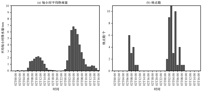
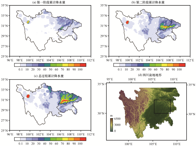
2017年5月2日07:00(北京时, 下同)至3日09:00四川盆地东北部发生了一次突发性暴雨天气过程。该次山地暴雨事件以对流性降水为主, 降水呈直角带状分布。结合图1及1 h累积降水量的演变特征(图略)可知此次降水过程可分为两个主要的强降水阶段: 第一阶段[2日07:00 -11:00, 图2(a)], 降水首先出现在四川广安和重庆潼南, 强降水持续了4 h, 强降水区呈东北-西南向带状, 降水大值区位于四川广安、 南充至达州等盆地丘陵低山一带, 最大小时雨量达40.7 mm, 最大过程雨量为63.7 mm; 第二阶段[3日01:00 -09:00, 图2(b)]降水分布变为东西经向带状, 降水大值区位于四川南充、 达州至重庆万州等盆地低山区一带, 四川广安、 巴中出现最大小时雨量(44.1 mm)和最大过程雨量(162.4 mm)。整个过程中[2日07:00至3日09:00, 图2(c)]四川盆地东北部的广安、 巴中、 达州、 广元东部、 南充大部均出现了≥50 mm的降水, 100 mm以上的降水集中在南充、 广安和达州, 累计降水量最大值位于广安蒲莲, 其中第二阶段的降水明显比第一阶段强, 约是第一阶段的2.5倍, 且位置向低山区倾斜。
4 多尺度天气系统的协同作用
针对新一代再分析资料ERA5在四川盆地的适用性, 通过对比4个时次(2日08:00、 20:00, 3日08:00、 20:00)500 hPa再分析资料流场和实际流场, 证实了ERA5再分析资料能够很好再现盆地及周边的大气环流形势。
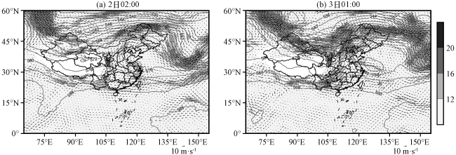
暴雨发生前, 500 hPa[图3(a)]亚洲中高纬为两槽一脊的环流型, 两槽分别位于新疆北部和西太平洋, 脊区位于中国东北。中低纬有浅槽东移, 四川盆地位于高空短波槽前, 西太平洋副高脊线稳定维持在23°N左右并且西伸, 有利于偏西南暖湿气流达川东。700 hPa云、 贵经四川到宁夏为西南气流并伴有低空急流活动, 该西南低空急流可将孟加拉湾的水汽输送至暴雨区。之后的12 h内, 高空环流形势稳定维持直至2日20:00中高纬槽脊东移(图略), 四川盆地位于高空槽区。大尺度低空急流与14:00相比, 强度加强, 四川盆地为南风。3日01:00[图3(b)], 高原低槽东移加深位于盆地内, 槽后冷平流南下影响四川盆地。副高脊线西伸明显, 与阿拉伯海的高压连通。700 hPa切变线东移至四川盆地东北部-陕西一线, 西南低空急流亦东移, 且在低空急流的左前侧盆地东北部有显著的风速及风向辐合。3日08:00, 500 hPa高空槽进一步东移至四川盆地东部, 700 hPa盆地转为西北风控制, 西南低空急流东移出川, 此次突发性暴雨过程也随之结束。
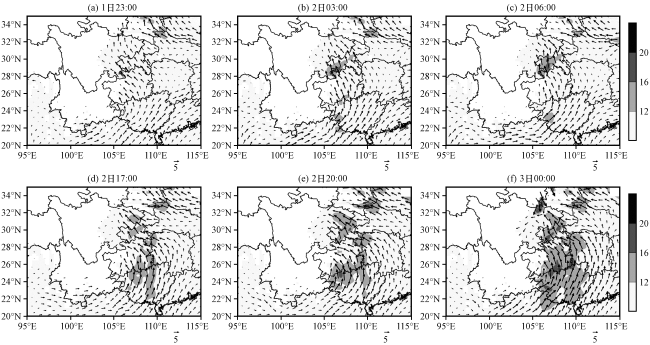
850 hPa低空, 1日23:00[图4(a)]在云贵高原上贵州北部大娄山东部山区有低空急流生成, 其强度约为12.34 m s-1, 之后的6 h中, 山区低空急流的强度和范围持续增大, 直至2日06:00[图4(c)]强度和范围达最大, 平均风速为14.67 m s-1, 最大风速为19.42 m s-1, 范围为28.5°N -30.5°N, 105°E -107°E。2日07:00, 在山区低空急流的出口区, 便有山地突发性暴雨产生。17:00[图4(d)]山区低空急流重新生成于重庆中部, 与此同时广西-贵州也有大尺度偏南风低空急流生成, 之后的5 h内, 急流强度持续增大。3日00:00[图4(f)], 在广元、 绵阳形成一偏北风低空急流, 重庆地区为偏东风低空急流, 东南风与西北风在盆地东北部形成一低层切变线, 且广西至贵州偏南风低空急流处于最强盛时期。因此01:00, 发生了第二阶段暴雨。可见, 850 hPa低空急流与暴雨的发生存在同步关系。
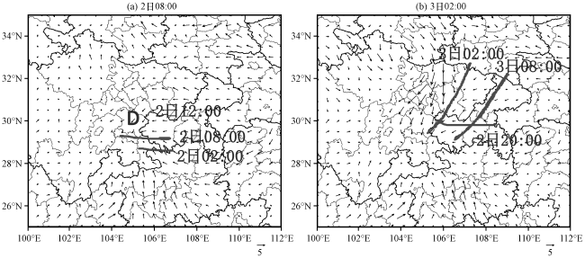
地面图(图5)上, 2日02:00从盆地东北进入盆地的东风在龙门山脉的阻挡作用下转为北风与来自南海经云贵高原抬升后的偏南气流在四川盆地南部至贵州省北部一带形成一中尺度地面辐合线。06:00, 地面辐合线北移, 短时强降水出现在辐合线以北1~1.5个纬距。08:00, 辐合线继续北移, 雨带也随之北移。到12:00, 辐合继续加强、 形成一中尺度低压。3日02:00, 由于东风的加强及北方冷空气的入侵, 地面至700 hPa都存在辐合气流, 地面辐合线位于700 hPa切变线的东部。08:00, 随着高空槽的东移以及北方冷空气的进一步入侵, 地面辐合线移至重庆东部, 本次强降水过程也在1 h之后结束。可见, 低层中尺度切变线或地面辐合线与暴雨区有很好的对应关系, 雨带随切变线而移动, 雨带的经纬型分布也取决于切变线的横竖分布形态。
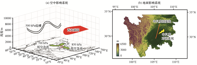
该类天气形势下, 有四种天气系统共同影响四川盆地东北部: 500 hPa高空槽使得槽后冷空气南下影响四川盆地, 588 dagpm西伸明显, 有利于低层暖湿气流(700 hPa来自孟加拉湾的西南气流和850 hPa来自南海的偏南气流)输送, 尤其是在第二阶段, 沿副高边缘的西南气流直接输送至川东北, 与冷空气在此交汇, 给四川盆地东北部带来大暴雨。由于高层天气系统影响而诱生的低层切变线(或辐合线)也直接影响暴雨的雨型。
综上, 此次四川盆地东北部突发性暴雨过程中的影响系统由图6归纳、 展示。
5 低空急流对暴雨的触发作用
5.1 低空急流与暴雨的对应关系
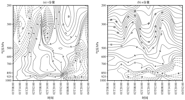
结合前述对低空急流的分析, 可知低空急流与暴雨存在同步关系, 因此本节着重分析风分量与暴雨的对应关系。v分量图[图7(a)]上, 2日02:00由于高空动量下传, 降水大值区对应偏南风为主的大风区, 07:00 -11:00四川盆地东北部出现第一阶段暴雨。700 hPa强风带维持了24 h, 直至3日01:00北方冷空气由低层侵入四川盆地东北部, 偏南风强风速带才消失。u分量图[图7(b)]上, 影响低层的主要是偏东风, 强风速带也在02:00开始形成, u分量的影响范围较低, 主要位于925~850 hPa。在第二阶段降水过程中(3日01:00 -09:00), 对流层低层出现两支低空急流, 一支位于云南、 贵州和重庆地区的700 hPa西南风低空急流, 其属于大尺度低空急流; 另一支位于四川盆地东北部到重庆西部的850 hPa东南风低空急流, 该急流属于山区边界层中尺度低空急流。可见两次低空急流的发展与暴雨有很好的对应关系。
5.2 有利的动力结构和稳定的垂直上升运动
由暴雨区(30.25°N -31.55°N, 106.05°E -108.05°E)垂直速度高度-时间剖面图[图8(a)]可以看到, 低空急流发展时, 垂直速度发生了明显的变化, 1日白天在低空急流建立前整层均为下沉运动, 在强降水的两个时段2日07:00 -11:00, 3日01:00 -09:00始终存在着触发对流的强烈的上升运动, 其中第一阶段上升运动伸展至300 hPa以上, 第二阶段垂直运动更强, 从地面至200 hPa均为上升运动, 在两个阶段之间的降水中断期, 低层为弱上升运动, 高层为下沉运动。可见, 低空急流出口区辐合使得暴雨区在两个阶段都维持持续的辐合上升运动。从暴雨区散度和涡度高度-时间剖面图[图8(b), (c)]可以看到, 低空急流发展时, 对流层低层散度场存在明显的变化, 1日白天均为正值, 23:00, 低层(850 hPa附近)的散度全部为负值, 且散度存在明显的日变化, 白天减弱夜晚加强, 这也与降水主要发生在夜间是一致的。当2日02:00短波槽东移时, 正涡度层比较深厚, 主要分布在300 hPa附近, 之后正涡度中心下传, 3日02:00正涡度中心移至850 hPa, 最为强盛, 中心值大于18 10-5 s-1。两个阶段暴雨过程中, 对流层中低层, 正涡度区域与辐合区范围相对应, 量级与散度相同。可见, 低空急流每次发展, 都在暴雨区相伴形成正涡度柱与强散度柱, 对暴雨的产生和维持十分有利。
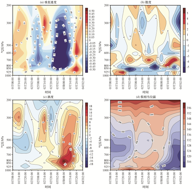
图8 2017年5月1日08:00至4日02:00暴雨区垂直速度(a, 单位: Pa s-1)、 散度(b, 单位: ×10-5 s-1)、 涡度(c, 单位: ×10-5 s-1)和假相当位温(d, 单位: K)的高度-时间剖面Fig.8 Height-time profile of vertical velocity (a, unit: Pa s-1), divergence (b, unit: ×10-5 s-1), vorticity (c, unit: ×10-5 s-1) and potential pseudoequivalent temperature (d, unit: K) over the rainstorm area from 08:00 on 1 to 02:00 on 4 May 2017 |
5.3 有利的位势不稳定层结
由 场[图8(d)]可见, 1日白天, 对流中低层为位势不稳定层结 , 1日23:00之后, 随着低空急流的建立, 位势不稳定增强, 等值线突然向上扩展, 表明暴雨区气团的暖湿属性明显增加, 中低层的 比白天增加4~8 K, 近地层 达340 K, 700 hPa以下均为位势不稳定层结, 700~500 hPa近似中性层结。3日01:00在850 hPa低空急流达到最强时, 该时刻是等 线的密集区, 迅速减小, 这与干冷空气的侵入有关。虽然 在02:00后减小, 但700 hPa以下仍为位势不稳定层结, 这种不稳定层结一直维持到20:00突发性暴雨结束。
综上所述, 我们认为这次暴雨过程的动力触发机制是850 hPa低空急流, 在两次强降水阶段由于低空急流的发展, 暴雨区由辐散气流变成辐合气流, 由下沉运动变成上升运动, 由位势弱不稳定层结变成位势强不稳定层结构成了暴雨发生必须具备的两个条件: 层结不稳定和一定的抬升条件。暴雨区低层始终维持位势不稳定层结、 强垂直上升运动、 正涡度柱和强散度柱相伴的特性, 这种结构的建立和维持是暴雨发生的正反馈机制之一。可见低空急流对本次暴雨有重要作用, 不仅将暖湿空气输送到四川盆地, 促使对流层低层的不稳定性增加, 为暴雨的发生提供了必要的水汽、 热力条件, 而且对暴雨产生动力触发作用。
6 地形以及冷侵入产生的增幅作用
6.1 地形的辐合抬升作用
散度剖面图[图9(a), (b)]上, 由于地形作用辐合区呈倾斜的带状。2日08:00, 地面至700 hPa四川盆地东北部附近共有4个辐合中心, 其中一个辐合中心位于700 hPa, 中心值达-6 10-5 s-1, 另外3个辐合中心位于850 hPa, 最强辐合中心的中心值达-12 10-5 s-1, 高层300 hPa为辐散区, 中心值为4 10-5 s-1。3日02:00, 在降水带上共有2个辐合中心, 均位于850 hPa, 中心强度达-12 10-5 s-1, 辐散中心仍位于高空300 hPa。这种低层辐合、 高层辐散的配置, 有利于垂直方向上形成大气抽吸效应, 从而加强垂直上升运动, 因此在3日02:00暴雨区有强烈的上升运动, 向上伸展至250 hPa[图9(d)]。
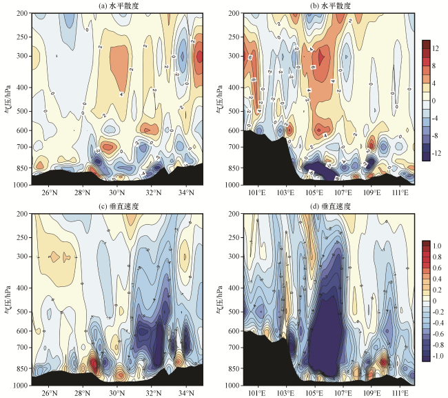
图9 2017年5月2日08:00水平散度(单位: ×10-5 s-1)和垂直速度(单位: Pa s-1)沿降水大值中心(106.45°E)的高度-纬度剖面(a, c), 3日02:00沿降水大值中心(31°N)的高度-经度剖面(b, d)Fig.9 Height-time cross-section of horizontal divergence (unit: ×10-5 s-1), vertical velocity (unit: Pa s-1) along the max value center of precipitation (106.45°E) at 08:00 on 2 (a, c) and along the max value center of precipitation (31°N) at 02:00 on 3 (b, d)May 2017 |
暴雨多发生在高大山脉背风坡和小尺度山脉的迎风坡, 降水极值多出现在山脉的迎风坡、 平原与山脉的过渡地区(陆汉城等, 2015; 朱乾根, 2007)。在暴雨的第一阶段[图8(a), 9(c)], 山脉的迎风坡有两个辐合中心, 强烈的垂直上升运动也出现在此, 秦巴山脉对风场的辐合抬升作用造成盆地东北部的迎风坡出现辐合区和强烈的垂直上升运动区。在暴雨的第二阶段[图9(b), (d)], 辐合区和强垂直运动上升区出现在川西高原高大山脉的背风坡, 且上升运动的强度高于第一阶段, 这与第二阶段干冷空气的侵入有关, 两个阶段降水的大值区出现在平原与山脉的过渡区即广安地区(图2)。
6.2 地形的阻挡作用
降水过程的雷达回波演变图(图10)显示出两个阶段的降水分别对应两次中尺度对流系统的发生发展过程。第一阶段降水的对流活动在地面辐合线以及大风区形成后1 h即2日03:00在盆地东部丘陵地区产生, 此时为几个分散的对流小单体, 随后对流单体强度逐渐加强, 范围也逐渐扩大, 这些小单体发展为一个较强的中尺度对流系统。中尺度对流系统在向东北方向移动的过程中于07:00分裂成两个块状回波, 位于广安的块状回波此时发展最旺盛, 07:00第一阶段的突发性暴雨出现。10:00西北位置的回波衰减消散, 东南位置的回波也在衰减并向四川盆地东北部移动, 11:00第一阶段降水结束。2日23:00, 四川盆地东北部的遂宁、 广安等地又有对流单体开始发展, 3日01:00, 对流发展显著增强, 第二阶段突发性暴雨于此时产生。03:00强对流发展成熟并一直维持在广安北部、 南充东部、 达州南部地区, 此时强度已达50 dBZ以上的局地强回波, 至05:00强回波的强度和影响范围达到最大。08:00中尺度对流系统移出四川盆地东北部, 09:00第二阶段突发性暴雨结束。
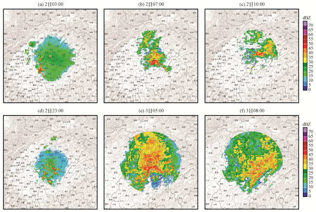
结合海拔分析可知, 两个降水阶段的中尺度对流系统首先在四川盆地东部位势较低的丘陵地带产生, 该处的平均海拔约为400 m, 之后向盆地东北部发展、 移动, 开始移速较快, 当移动到(31°N, 107°E)附近时, 因大巴山区的阻挡而移速明显减慢, 停滞在此并发展旺盛。在强降水过程的第二阶段, 川东北地形的阻挡作用更为显著, 3日03:00开始, 中尺度对流系统就停滞在强降水区。
6.3 冷侵入对暴雨的增幅作用
由于假相当位温( )在绝热过程中具有保守性, 被广泛用于代表空气的温度、 湿度状况。王安宇等(1999)指出在夏季风推进期间, 30°N以南可用340 K等值线来代表暖湿空气前沿, 故本小节结合低层切变线和低空急流的位置来分析900 hPa、 800 hPa和700 hPa 的分布(图11)。从图11中可以看出, 900 hPa上, 的大值区位于贵州与四川盆地的交界处, 最大值为362 K; 340 K等值线位于31°N, 等 梯度大值区呈西南-东北走向。800 hPa上, 的大值区位于贵州北部-重庆西部; 340 K等值线位于31.5°N, 等 梯度大值区比900 hPa有所减小。700 hPa上, 四川盆地东北部为等 的大值区, 340 K等值线位于32°N左右, 在盆地北部边缘是等 梯度大值区。假相当位温高、 低值区在不同层次位置的变化反映了第二阶段降水过程中冷、 暖空气的活动情况。以上对 水平与垂直分布的分析表明, 3日02:00, 北方冷空气从低层接近地面的高度开始侵入, 与偏南风低空急流输送的暖湿空气在盆地东北部交绥, 使垂直上升运动增强, 有利于暴雨在第二阶段出现增幅。
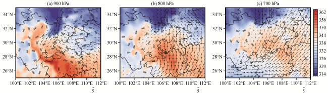


以上通过对水平散度、 垂直运动、 低空急流以及中尺度对流系统的诊断, 反映出四川盆地周围复杂的地形为本次暴雨提供了有利的环境条件: 秦巴山脉迎风坡以及青藏高原东侧背风坡均引起的辐合抬升, 大巴山脉的阻挡使得中尺度对流系统在盆地东北部停滞并发展旺 盛。其中突发性暴雨第二阶段高于第一阶段的主要原因主要是干冷空气由低层至高层的侵入。
盛。其中突发性暴雨第二阶段高于第一阶段的主要原因主要是干冷空气由低层至高层的侵入。7 结论与讨论
考虑四川盆地以及周边复杂的地形环境, 对2017年5月2 -3日四川盆地东北部一次突发性暴雨过程中的影响系统进行了梳理、 总结, 初步揭示多尺度天气系统的协同作用, 并且从动力、 热力条件诊断了低空急流对暴雨的触发作用, 分析了山地地形对天气系统及暴雨的影响, 主要结果归纳如下:
(1) 低层中尺度切变线与高层辐散流场的耦合为突发性暴雨的发生创造了有利环境场, 切变线与暴雨区有很好的对应关系, 雨带随切变线而移动, 雨带的经纬型分布也取决于切变线的横竖分布形态。
(2) 低空急流是本次山地突发性暴雨的主要触发因子, 其在暴雨前一直维持增强趋势。大尺度西南低空急流与中小尺度山区边界层低空急流叠加, 在四川盆地东北部形成正涡度柱和低层强辐合柱的动力耦合, 低空急流出口区和地形的辐合抬升共同造成强烈的垂直上升运动, 构成了山地暴雨突发的动力条件。
(3) 北方冷空气自低层逐渐向高层侵入, 低层切变线及辐合上升运动是暴雨在第二阶段出现增幅的重要原因。
(4) 山地地形对本次暴雨的增幅作用主要体现在动力抬升和阻挡作用: 盆地北边界的秦巴山脉迎风坡和盆地西边界的青藏高原东麓背风坡均有强烈的辐合上升运动。东移的中尺度对流系统由于盆地东北部山地的阻挡而停滞并发展旺盛。
与已有的四川盆地暴雨研究相比, 本文基于新一代高分辨率再分析资料较为全面探究了四川盆地及周边山地突发性暴雨的动力影响因子, 对低空急流对山地暴雨的触发作用进行了针对性分析, 为揭示我国西部山地突发性暴雨的特征与机理提供了一些线索。但研究结果(如低空急流与地形的叠加对山地突发性暴雨降的触发作用)尚需要应用山地暴雨加密观测试验资料及中尺度模式数值试验进一步证实, 同时不同尺度、 不同高度低空急流的耦合作用以及暴雨的水汽源地和水汽输送等重要问题, 也有待进一步研究。