
1 引言
土壤湿度通过改变土壤的热容量、 地表反照率和地表蒸散发, 并影响植被生长, 直接或间接的影响局地及区域气候, 是陆面过程中的关键物理量, 在气候变化中的作用仅次于海温(Sea Surface Temperature, SST)(Chahine, 1992; 林朝晖等, 2008)。因此, 开展土壤湿度模拟和变化研究, 具有重要的理论和实际价值。陆面模式可以充分利用观测数据和遥感数据, 模拟高分辨率和时空连续的多层土壤湿度, 因其覆盖面广、 时间序列长的特点而受到重视。研究表明CLM3.0和CLM3.5模拟的土壤湿度与站点观测数据在空间变化上有较好的一致性, 但深层模拟结果的时间变率存在低估, 且模拟效果会随土层深度的加深变差(Li et al, 2010; 朱晨等, 2013; 韩帅等, 2017; 陈萍萍等, 2018); CLM4.0模拟的土壤湿度在中国区域也有较好的效果, 但模拟值存在低估现象, 并在江淮、 河套和东北地区模拟值均存在系统性偏大(赖欣等, 2014; 熊建胜等, 2014; 何媛等, 2017)。有研究表明Noah-MP陆面模式也同样能很好的模拟出中国区域0~10 cm土壤湿度的空间分布和时间变化特征, 但对冻土融化时期东北地区的土壤湿度存在轻微低估现象(朱智, 2016; 师春香等, 2018), 并且随着深度的增加, 土壤湿度的模拟效果有所下降(刘火霖等, 2020)。因此, 利用陆面模式模拟土壤湿度在中国区域具有一定的适用性, 但模拟精度仍有待进一步提高(刘川等, 2015)。
土壤质地是重要的土壤特征参数, 并对土壤湿度变化具有重要影响(Shao et al, 2001), 在陆面模式中, 土壤水力性质定义了土壤湿度、 土壤基质势以及导水率之间的关系, 土壤质地通过影响土壤基质势以及导水率, 从而对土壤湿度的模拟产生作用, 使用高质量的土壤质地数据是提高陆面模式模拟土壤湿度效果的有效方法(Laio et al, 2006; Gao et al, 2015)。Dong el al (2017)的研究发现, 土壤质地对中尺度土壤湿度空间格局的影响往往强于降水, 在相同大气强迫场驱动下, CoLM模拟的表层土壤湿度对土壤质地较为敏感(梁晓等, 2008); 将CLM3.5自带的土壤质地数据替换为根据中国第二次土壤调查(Second National Soil Survey, SNSS)结果制作的土壤质地后, 能够有效改进CLM3.5模拟土壤湿度的结果(吴龙刚等, 2014); 何媛等(2017)合理优化CLM4.0中土壤有机质和土壤质地参数, 模拟的土壤湿度结果更加合理; 使用实测土壤数据修改土壤属性后, CLM4.5在青藏高原高寒草甸各层土壤湿度的模拟结果普遍更接近观测值(苏有琦等, 2020)。因此, 土壤质地数据对陆面模式土壤湿度的模拟具有重要影响。
CLDAS/Noah-MP系统是基于CLDAS(中国气象局陆面数据同化系统)的大气强迫数据驱动Noah-MP陆面模式模拟系统, 模拟的土壤湿度已被证明在中国区域有较好的适用性(朱智, 2016; 师春香等, 2018), 但缺乏土壤质地对其影响的研究和评估, 为此, 本文利用FAO和SNSS两套土壤质地数据开展土壤质地数据对土壤湿度模拟的影响研究, 为CLDAS/Noah-MP模拟参数的运用及研究提供科学依据。
2 数据来源与方法介绍
2.1 数据来源
大气强迫数据: 研究使用的大气强迫数据来自中国气象局陆面数据同化系统(China Meteorological Administration Land Data Assimilation System Version, CLDAS)2.0版本, 包含空间分辨率0.0625°× 0.0625°、 时间分辨率1 h的温、 压、 湿、 风、 降水、 短波辐射6个要素。对CLDAS产品质量的验证和评估已有较多研究, 证实该数据有较高质量和应用价值(朱智, 2016; Qin et al, 2017; Yang et al, 2017; 沈润平等, 2019)。
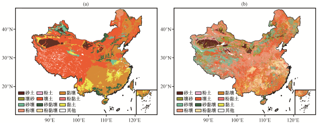
土壤质地数据: 土壤质地是根据机械组成划分的土壤类型, 土壤机械组成(或称颗粒组成)是根据土壤机械分析, 分别计算土壤各粒级(如砂粒、 粉粒和粘粒)重量的相对百分含量(黄昌勇等, 2010), 在Noah-MP模式中, 土壤质地的分类采用美国农部(United States Department of Agriculture, USDA)制。研究使用的土壤质地数据分为两组, 一组为Noah-MP模式中自带的土壤质地数据, 来自STATSGO/FAO(State Soil Geographic, STATSGO; Food and Agriculture Organization of the United Nations, FAO)混合土壤质地数据集, 该数据集在中国区域使用的实测资料少, 空间代表性较差(王绍武, 2018)。另一组土壤质地数据为Shangguan et al(2012)根据中国第二次土壤调查(Second National Soil Survey)的结果, 使用多边形连接方法发展的一个1 km的中国区域的土壤粒度分布数据(SNSS, http: //globalchange.bnu.edu.cn/research/soil), 该数据使用8979个土壤剖面数据, 空间分布广, 能较好地反映中国区域土壤质地的分布特点, 是现有的较高精度的中国区域土壤质地数据(吴龙刚等, 2014; 王绍武, 2018)。结合USDA土壤质地三角图, 生成中国区域内USDA制十二类土壤质地数据, 分别为砂土、 壤砂、 粉土、 砂壤、 壤土、 粉壤、 砂黏壤、 黏壤、 粉黏壤、 砂黏土、 粉黏土、 黏土(黄昌勇等, 2010), 采用最大面积法将其重采样为0.0625°×0.0625°。
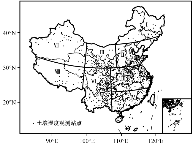
站点观测数据: 土壤湿度观测数据来源于国家气象信息中心资料服务室的2014 -2015年逐小时观测数据, 本研究利用0~10 cm, 10~40 cm深度的观测值对CLDAS/Noah-MP模拟结果进行验证, 其中10~40 cm的土壤湿度观测值由10~20 cm、 20~30 cm、 30~40 cm三层观测数据计算平均得到。研究采用韩帅(2015)提出的方法, 对土壤湿度观测数据进行质量控制, 主要包括以下步骤: (1)土壤体积含水量的观测仪器的测量范围为0~0.5 m3·m-3, 观测仪器不会出现在土壤没有水分的场地中, 剔除观测数据≤0 m3·m-3和>0.5 m3·m-3的值; (2)当温度小于0 ℃时, 由于土壤中冰水混合物的存在, 观测仪器无法正常观测, 因此, 在进行空间尺度上的分析时, 只保留各站点4 -10月的观测值; (3)由于不同土壤湿度观测站点开始业务化的时间不同, 并且观测值还存在有缺失和错误(≤0 m3·m-3和>0.5 m3·m-3的值)的情况, 因此剔除有效观测时间<180天的站点。最后, 经过质量控制后, 得到968个站点的0~10 cm, 10~40 cm的观测值, 用于对模拟结果进行精度验证分析。并参考朱智(2016)的分区方法(表1), 将中国区域分为8个分区进行比较分析[图1, 图1及以下各图是基于国家测绘地理信息局标准地图服务网站下载的审图号为GS(2017)3320的中国地图制作, 底图无修改]。
表1 各研究区经纬度范围(朱智, 2016)Table 1 Latitude and longitude range of each study area (from Zhu, 2016) |
| 区号 | 研究区 | 纬度范围 | 经度范围 |
|---|---|---|---|
| Ⅰ | 东北 | 42.5°N -54.0°N | 110.0°E -135.5°E |
| Ⅱ | 华北 | 35.0°N -42.5°N | 110.0°E -130.0°E |
| Ⅲ | 江淮 | 27.5°N -35.0°N | 107.5°E -124.0°E |
| Ⅳ | 东南 | 17.5°N -27.5°N | 107.5°E -124.0°E |
| Ⅴ | 西北东部 | 35.0°N -44.0°N | 97.5°E -110.0°E |
| Ⅵ | 西南 | 20.0°N -35.0°N | 97.5°E -107.5°E |
| Ⅶ | 西北西部 | 35.0°N -49.5°N | 74.0°E -97.5°E |
| Ⅷ | 青藏高原 | 26.5°N -35.0°N | 78.0°E -97.5°E |
2.2 方法介绍
2.2.1 CLDAS/Noah-MP系统
中国气象局陆面数据同化系统(CLDAS)利用数据同化技术, 对地面观测、 卫星观测和数值模拟等产品进行融合, 获取温、 压、 湿、 风、 降水和太阳短波辐射等大气驱动数据; CLDAS-V2.0在CLDAS-V1.0的基础上, 融入了更多的高分辨率地表信息, 并耦合了多个陆面模式, 采用最优插值(OI)、 多重网格变分同化(STMAS)、 概率密度函数匹配(CDF)、 地形校正、 物理反演等技术, 建设了覆盖亚洲区域(0° -65°N, 60°E -160°E), 空间分辨率0.0625°×0.0625°, 时间分辨率1 h的大气驱动场产品, 在中国区域具有较高质量(龚伟伟等, 2015; 陈萍萍等, 2018; 师春香等, 2018)。
Noah-MP为Noah陆面模式(version 3.0)的增强版, 引入植被冠层, 分开计算植被冠层对水分平衡和地表能量的影响; 修正二流传输方案中的辐射传输误差; 增加了短期动态植被模型、 三层雪层方案和基于径流方案的地下水模型。此外, 还可以对动态植被、 辐射传输、 气孔阻抗、 冻土渗透率、 冻土中过冷液态水、 辐射传输、 雪面反照率等参数化方案进行选择(Niu et al, 2011)。Noah-MP陆面模式中土壤湿度通过Richard公式计算:
式中: 为土壤体积含水量(单位: m3·m-3); 为时间(单位: s); 为土壤表面正向上的高度(单位: mm); 为土壤水通量(单位: mm·s-1); 为导水率(单位: mm·s-1); 为土壤基质势(单位: mm)。
式中: 为土壤第i层平均体积含水量(单位: m3·m-3), 为 内 的变化; 为土壤第i层的平均水汽汇项(单位: mm·s-1)。 定义为:
每层的厚度为:
根据式(2) , 为:
其中: , 为:
式中: 为饱和导水率(单位: mm·s-1), 为饱和土壤基质势(单位: mm), 是取决于土壤质地的常数, 为界面i的导水率(单位: mm·s-1)。
2.2.2 土壤湿度模拟方案设计
研究设计两组实验, 第一组实验利用STATSGO/FAO土壤质地类型数据, 使用CLDAS/Noah-MP系统模拟中国区域第一层(0~10 cm)和第二层(10~40 cm)土壤湿度, 记为FAO; 第二组实验将土壤质地类型替换为通过SNSS粒度分布数据计算的土壤质地, 使用CLDAS/Noah-MP模拟中国区域前两层土壤湿度。本研究采用默认参数化方案, 植被类型数据来自于美国地质调查局的全球植被类型, 对使用FAO土壤质地类型的Noah-MP陆面模式和SNSS土壤质地类型的Noah-MP陆面模式进行22年的spin-up过程, 分别得到一个稳定的初始场, 最后输出2014年每日00:00(世界时, 下同), 06:00, 12:00, 18:00四个时次的土壤湿度模拟结果, 空间分辨率为0.0625°×0.0625°, 将其求平均, 作为当日土壤湿度, 并进行计算(为了保证数据精度, 模式输出的栅格图像为等经纬度的地理坐标系, 与等面积投影下的标准中国地图相比略有变形, 本论文的数值计算得到了南京信息工程大学高性能计算中心的计算支持和帮助)。
2.2.3 差异性检验
为了判断两组实验模拟结果差异是否显著, 使用 表示差异性:
式中: 表示两组数据之间的差异性, >0.01则认为存在差异, >0.1则认为差异显著; 和 为两组数据对应的值。配对样本T检验是检验两组相关的样本是否存在显著差异的有效途径, 设 , 分别为配对样本数列, 样本差值 , 则检验统计量为:
2.2.4 精度评价指标
式中: 为样本数量; 为观测站点数据; 为模拟结果; 和 分别为观测值和模拟值的平均值。
3 结果与分析
3.1 土壤质地类型数据比较
从表2和图2可看出, FAO和SNSS两种不同土壤质地类型数据的不同土壤质地类型面积占比存在较大差异, 特别是粉壤、 壤土和黏壤, 绝对差值达到28.06%, 27.98%和17.36%。FAO的壤土面积占比高达52.75%, 主要分布在北方干旱半干旱区和青藏高原区, 但SNSS的壤土仅有24.77%, 大部分FAO中的壤土被SNSS分为壤砂(西北北部)、 砂壤(青藏高原)以及粉壤(西北东部和华北地区), 在东南和西南地区, SNSS的壤土占比增多。FAO在中西南和东南地区的主要土壤质地类型为黏壤和黏土, 它们中的一部分在SNSS中则被分为粉黏壤和壤土。SNSS在东北地区的砂壤和壤砂的面积增加。
表2 中国区域FAO和SNSS土壤质地类型的面积占比Table 2 Area proportion of soil texture of FAO and SNSS in China |
| 土壤质地类型 | STATSGO/FAO /% | SNSS/% | 绝对差值/% |
|---|---|---|---|
| 砂土 | 4.48 | 4.65 | 0.17 |
| 壤砂土 | 0.07 | 9.92 | 9.85 |
| 砂壤 | 2.98 | 14.17 | 11.19 |
| 粉壤 | 1.37 | 29.43 | 28.06 |
| 粉土 | 0 | 0.86 | 0.86 |
| 壤土 | 52.75 | 24.77 | 27.98 |
| 砂黏壤 | 6.46 | 0.71 | 5.75 |
| 粉黏壤 | 0.14 | 5.46 | 5.26 |
| 黏壤 | 26.11 | 8.75 | 17.36 |
| 粉黏土 | 0 | 0.45 | 0.45 |
| 黏土 | 5.64 | 0.63 | 5.01 |
3.2 两组实验日均土壤湿度差异性分析
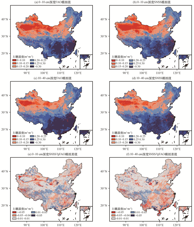
从不同土壤质地类型数据下CLDAS/Noah-MP模拟的2014年0~10 cm和10~40 cm深度的土壤湿度日均值以及模拟差值(图3)可以看出, FAO与SNSS前两层模拟值整体空间分布较为一致, 均呈现从西北到东南由干变湿的趋势。FAO与SNSS在中国区域第一层模拟结果日均值的平均值分别为0.214 m3·m-3与0.211 m3·m-3, 第二层分别为0.232 m3·m-3与0.227 m3·m-3, SNSS土壤湿度模拟均值较小, 两组实验模拟的土壤湿度皆随深度增加变大。SNSS与FAO第一层模拟值的差值范围为 -0.249~0.135 m3·m-3, 23.2%的区域差异性大于10%, 74.9%的区域差异性大于1%, 变化幅度在0.05 m3·m-3以上主要出现在西北和东南地区; 第二层SNSS与FAO模拟值的差值范围为-0.245~0.124 m3·m-3, 20.8%的区域差异性大于10%, 69.8%的区域差异性大于1%, 和第一层模拟结果相比较, 东南、 江淮和西南东部地区, SNSS与FAO模拟值的差值小于-0.01 m3·m-3的区域增加, SNSS土壤湿度模拟值相比FAO变小; 而西北地区差值在-0.01~0.01 m3·m-3范围内的区域变多, 表示第二层两组实验西北地区模拟结果更加接近。对SNSS和FAO两组实验日均模拟结果进行配对样本T检验, 在1%显著性水平上未拒绝原假设, 两组实验的模拟结果存在显著性差异, 表明土壤质地对CLDAS/Noah-MP土壤湿度模拟具有较大影响。结合中国区域FAO与SNSS土壤质地类型空间分布图(图2)不难看出, 在FAO中为壤土、 黏壤但在SNSS中却是砂黏壤、 砂壤等砂粒含量较高的土壤质地类型的区域, 以及在FAO中为黏壤但在SNSS中为粉壤的区域, SNSS与FAO模拟值的差值多为负值, SNSS模拟值小于FAO模拟值; 江淮北部、 青藏高原东部和西南地区, FAO中为砂壤、 砂黏壤, 但在SNSS中却是壤土的区域, 以及在FAO中为壤土但在SNSS中为粉壤的区域, SNSS与FAO模拟值的差值多为负值, SNSS模拟值小于FAO模拟值。
3.3 土壤湿度模拟结果的时间序列与误差分析
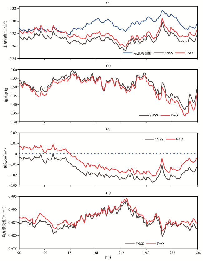
为便于分析, 研究通过双线性内插算法, 将模拟结果通过经纬度信息插值到观测站点, 计算0~10 cm深度所有站点逐日平均值, 与观测值进行比较, 并计算观测值与模拟值的相关系数与误差统计结果(图4), 可以看出FAO和SNSS两组土壤湿度模拟实验的模拟值均能基本反映土壤湿度随时间变化的规律, 两层土壤湿度模拟值和观测值的曲线波形和峰谷相似, 能反映出土壤湿度的短期震荡; 两组实验第一层的模拟值结果比较接近, 但SNSS模拟值的曲线更接近观测值, SNSS模拟结果与观测值相关系数在0.30~0.67, 10月整体表现较差; 与FAO相比, SNSS在大多数日次的相关系数大于FAO, 平均提高了0.04; 模拟值与观测值的偏差介于-0.024~0.015 m3·m-3, 除10月份出现较大的负偏差外, 其他日次的偏差表现整体较好, SNSS优于FAO; SNSS的均方根误差范围为0.076~0.090 m3·m-3, 同样在大多数日次低于FAO的均方根误差, 平均降低了0.003 m3·m-3; 整体而言, 0~10 cm深度SNSS土壤质地对CLDAS/Noah-MP土壤湿度模拟精度有所改善。
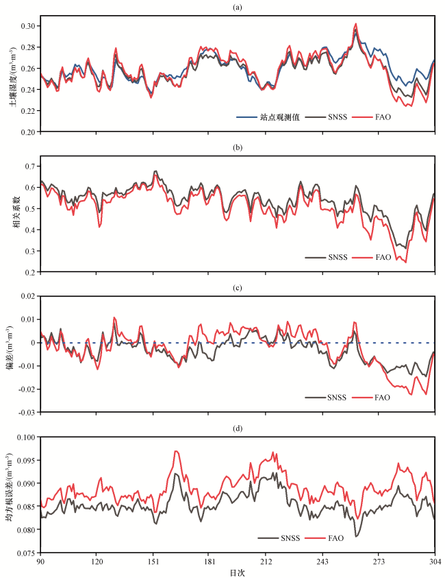
计算10~40 cm深度所有站点逐日平均值, 与观测值进行比较, 并计算观测值与模拟值的相关系数与误差统计结果(图5)可以看出, 10~40 cm深度两组实验的模拟值相比观测值都偏低, 尤其是夏季, 模拟结果出现明显低估的现象。相比第一层的模拟结果, 第二层模拟值的相关系数普遍较低, 在0.37~0.59, 夏季两组实验的相关性较为一致, 其他大多数日次SNSS的相关系数依然大于FAO; SNSS的偏差所有日次均小于FAO, 4月份更接近0, 但在其他日次存在低估现象; 模拟值与观测值的均方根误差在0.080~0.99 m3·m-3, SNSS的结果在4、 5月份的模拟结果明显好于FAO, 其他日次则没有明显差异; 整体而言, 10~40 cm深度CLDAS/Noah-MP的模拟效果比0~10 cm差, SNSS模拟结果比FAO略有改进。
3.4 土壤湿度模拟结果不同区域的空间误差分析
土壤温度小于0 ℃时, 由于站点观测的土壤湿度值严重低于实际土壤湿度(韩帅, 2015; 师春香等, 2018), 影响结果分析, 为此, 研究选用4 -10月的数据, 对应分析两组质地实验与观测值之间的相关性和误差特征(表3)。SNSS与FAO第一层土壤湿度模拟结果与观测值在中国区域的相关系数分别为0.667和0.653, 均方根误差分别为0.071 m3·m-3和0.077 m3·m-3; 第二层SNSS与FAO土壤湿度模拟结果与观测值在中国区域的相关系数分别为0.538和0.518, 均方根误差分别为0.077 m3·m-3和0.078 m3·m-3, SNSS模拟结果整体表现较好。从偏差来看, 青藏高原地区两组实验的模拟结果出现高估现象, 但整体而言, SNSS模拟结果偏差小于0的区域较多, 尤其是10~40 cm深度, 大多数区域模拟值均存在低估现象; 0~10 cm深度, SNSS在除华北、 西北、 青藏高原以外的其他区域偏差更接近0, 但第二层模拟结果出现明显的低估现象。东南地区两组实验模拟结果与实测值相关性较高, 大部分站点与模拟值的相关系数大于0.8, 整体相关系数也在0.8以上, 与FAO模拟结果比较, 东南地区第一层和第二层SNSS模拟结果的均方根误差分别降低了0.011 m3·m-3和0.005 m3·m-3; 西南地区第一层和第二层的模拟精度有所改进, 东北地区第一层SNSS的模拟效果较好, 但第二层模拟精度没有明显改进。
表3 Noah-MP土壤湿度模拟值与观测值各区域相关系数、 偏差和均方根误差Table 3 R, Bias and RMSE between Noah-MP soil moisture simulation value and observed value |
| 研究分区 | 土壤深度 | 相关系数 | 偏差/(m3·m-3) | 均方根误差/(m3·m-3) | |||
|---|---|---|---|---|---|---|---|
| SNSS | FAO | SNSS | FAO | SNSS | FAO | ||
| 东北 | 0~10 cm | 0.566 | 0.523 | -0.002 | 0.011 | 0.056 | 0.061 |
| 10~40 cm | 0.558 | 0.562 | -0.031 | -0.018 | 0.067 | 0.065 | |
| 华北 | 0~10 cm | 0.513 | 0.505 | -0.031 | -0.028 | 0.058 | 0.059 |
| 10~40 cm | 0.337 | 0.316 | -0.056 | -0.052 | 0.079 | 0.078 | |
| 江淮 | 0~10 cm | 0.714 | 0.720 | -0.021 | -0.025 | 0.072 | 0.078 |
| 10~40 cm | 0.585 | 0.556 | -0.030 | -0.022 | 0.072 | 0.073 | |
| 东南 | 0~10 cm | 0.808 | 0.805 | 0.005 | 0.010 | 0.075 | 0.086 |
| 10~40 cm | 0.668 | 0.628 | -0.012 | 0.005 | 0.071 | 0.076 | |
| 西北北部 | 0~10 cm | 0.581 | 0.572 | 0.006 | 0 | 0.066 | 0.064 |
| 10~40 cm | 0.441 | 0.438 | -0.004 | -0.010 | 0.072 | 0.075 | |
| 西南 | 0~10 cm | 0.712 | 0.705 | 0.010 | 0.014 | 0.085 | 0.090 |
| 10~40 cm | 0.606 | 0.594 | -0.005 | 0.004 | 0.077 | 0.080 | |
| 西北西部 | 0~10 cm | 0.294 | 0.267 | -0.045 | -0.039 | 0.068 | 0.070 |
| 10~40 cm | 0.259 | 0.257 | -0.055 | -0.057 | 0.107 | 0.109 | |
| 青藏高原 | 0~10 cm | 0.485 | 0.474 | 0.078 | 0.071 | 0.113 | 0.109 |
| 10~40 cm | 0.593 | 0.596 | 0.096 | 0.090 | 0.107 | 0.103 | |
相关系数均通过α=0.01的置信度检验 |
4 结论与讨论
基于SNSS和FAO两套土壤质地数据, 使用CLDAS/Noah-MP对中国区域不同深度的土壤湿度进行模拟, 并利用968个观测站点的数据对模拟结果进行评估, 得到以下结论:
(1) 两种不同土壤质地数据在中国区域差别明显, 尤其是粉壤、 壤土和黏壤的面积占比存在较大差异。CLDAS/Noah-MP模拟的不同深度土壤湿度对土壤质地均较为敏感, 两组实验结果差别较大的区域主要集中在西北和东南地区。
(2) CLDAS/Noah-MP的模拟结果能较好的体现土壤湿度的日变化特征, 相比FAO, SNSS的模拟结果在0~10 cm明显更好。第二层的模拟精度相比0~10 cm有所下降, 且出现整体低估问题, 尤其是SNSS几乎所有日次都比观测值要低, 但4、 5月份的模拟结果相比FAO依然有较为明显的改善。
(3) 从区域尺度来看, 虽然在青藏高原地区两组实验均出现明显的高估现象, 但SNSS的模拟结果在大部分区域存在低估问题, 尤其是10~40 cm深度。与FAO模拟结果比较, SNSS在东南和西南地区所有深度的模拟效果均有所改进, 东北地区0~10 cm深度SNSS的模拟效果较好, 但10~40 cm深度的模拟精度有所下降。
通过上述结论可以看出, 使用高质量的土壤质地数据能够有效改善土壤湿度的模拟精度, 但土壤质地数据还有进一步改进的空间。本文是在默认参数化方案下, 开展土壤质地对Noah-MP土壤湿度模拟的影响研究, 土壤质地对土壤湿度模拟的影响也可能随着参数化方案的不同而发生变化, 还需要深入讨论。此外, 本文仅评估了土壤质地对土壤湿度模拟的影响, 植被类型数据可以为陆面模式提供丰富的下垫面信息, Noah-MP中一些反映地表特征的参数, 如地表反照率、 冠层粗糙度、 叶面积指数等, 都是依植被类型确定(Niu et al, 2011), 使用高质量的植被类型数据, 也是提高模式模拟精度的有效途径。后期有待开展不同的模拟模型、 参数化方案和植被类型等其他地表参数对模拟结果的影响研究。