
1 引言
气候干湿状况对区域生态环境有着重要影响, 一直是气候学领域的关注重点(刘珂和姜大膀, 2015), 并且在全球变暖的情况下, 干旱事件频发, 对全球水资源的安全构成严重威胁(Mishra and Singh, 2010), 干旱已经是世界上最具破坏性的自然灾害之一(Yu et al, 2014)。
干旱形成原因比较复杂, 且形成以及发展过程中影响因素较多, 为了更好的监测和研究干旱, 学者们普遍使用比较容易获得的观测资料建立干旱指数(王林和陈文, 2014; 王素萍等, 2020), 以此来简化复杂的干旱现象(李伟光等, 2012; 周丹等, 2014)。目前使用比较广泛, 应用比较成熟的干旱指数主要有帕默尔干旱指数(Palmer Drought Severity Index, PDSI), 这是美国使用最广泛的气象干旱指数(Heim, 2002), 它充分考虑了温度、 降水及下垫面的影响(He et al, 2019)。但是PDSI也存在一些缺陷, 例如其时间尺度固定, 无法准确的识别多尺度的干旱、 计算复杂、 空间可比性差等问题, 虽然很多问题随着自修正PDSI(self-calibrating PDSI)的发展得以解决(Wells et al, 2004), 但其时间尺度固定的不足仍没有得到妥善处理(Vicente-Serrano et al, 2011)。近年来, 干旱具有多时空特征的概念被广泛认可(Hayes et al, 1999), 标准化降水指数(Standardized Precipitation Index, SPI)的出现也很好的解决了干旱的多时空尺度的问题, 该指数具有不同时间尺度且计算简单(黄梦杰等, 2020), 可以较为准确的反映干旱趋势(朱圣男等, 2020), 但SPI的不足在于其仅仅考虑了降水因素, 而没有考虑其他可以影响干旱的因素(Chen and Sun, 2015)。在全球变暖的背景下, 温度对干旱的影响已经越发重要。全球气候模型模拟的结果表明PDSI可以很好的预测变暖引起的干旱, SPI则没有这样的表现(Dubrovsky et al, 2008)。因此, 基于两种指数的优缺点, Vicente-Serrano et al(2010)建立了标准化降水蒸散指数(Standardized Precipitation Evapotranspiration Index, SPEI), 该指数使用降水和蒸发数据计算得到, 不仅解决了SPI未考虑温度变化的问题, 同时又继承了SPI多时间尺度的优势, 从而弥补了PDSI的缺陷(温庆志等, 2020)。所以SPEI结合了PDSI和SPI的优点, 是当前干旱监测、 研究的理想指标(Zhao et al, 2017)。
干旱指降水相对于长期平均水平减少, 而水汽条件是降水形成的重要条件之一, 水汽来源及强度更是直接影响降水的形成和强度(高松影等, 2020), 因此研究水汽输送有助于理解干湿演变机制。目前学者们已经做了大量关于水汽输送的研究工作, 例如徐祥德等(2002)的研究指出了高原水汽输送“大三角扇型”对中国及东亚旱、 涝异常的重要影响; Zhang et al(2017)认为由西风急流和印度季风分别携带的水汽导致了青藏高原的降水; Zhang et al(2019)以32°N为界将青藏高原分为南北两各区域, 分别受亚洲季风和西风控制, 并指出其主要水汽源地分别是高原东南部到印度洋地区以及高原到欧洲区域。这些研究主要是基于欧拉方法, 该方法的主要缺点是无法准确建立水汽源地和降水区域关系, 也没办法定量水汽源地的贡献(曾钰婷等, 2020), 而近年来, 拉格朗日方法越来越多的被用于研究水汽输送, 该方法可以追踪气团的运动轨迹, 特别是基于拉格朗日方法的粒子扩散模型(Flexible Particle Dispersion Model, FLEXPART)的应用(Stohl and James, 2004), 克服了早期拉格朗日方法无法定量判断气团扩散过程中的水汽耗散(Sodemann et al, 2008), 陈斌等(2011)利用该模型诊断了一次极端降水的水汽输送情况, 并定量估算了不同水汽源区的贡献; Sun and Wang (2014)利用FLEXPART模拟了2000 -2009年期间全球空气轨迹, 揭示了中国半干旱草地的水汽源; 朱丽等(2019)利用FLEXPART研究黄河源区异常降水情况下的水汽输送特征, 发现在正负异常降水情况下的水汽输送存在明显差异。
若尔盖高原是中国面积最大的高原湿地, 对气候变化非常敏感(李建军等, 2016), 并且位于黄河源区, 被誉为黄河上游的“蓄水池”(李志威等, 2014), 因此研究若尔盖的干湿状态及其相应的水汽输送特征有着重要意义。但目前关于若尔盖的研究多基于生态(方宇等, 2020)、 径流(刘佳等, 2016)、 能量(陆宣承等, 2020)等方面, 而关于不同干湿演变条件下的水汽输送的研究很少, 因此本文基于若尔盖地面观测站的观测资料计算SPEI, 以此提取极端干湿状态, 利用FLEXPART模拟被不同干湿状态对应的水汽输送特征, 识别可能的水汽源地, 并定量评估各水汽源地的贡献率。研究结果将有助于从水汽输送的角度理解若尔盖乃至黄河源区的干旱机制, 从而加深对区域水循环的理解。
2 研究区域、 资料及模式介绍
2.1 研究区域
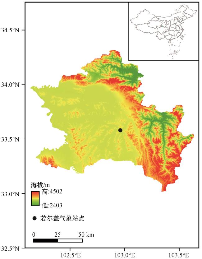
若尔盖区域(图1 , 32.93°N -34.32°N, 102.13°E -103.65°E)地处青藏高原东部边缘与季风区交接的区域, 海拔2403~4502 m, 属高原寒温带湿润季风气候, 年平均气温1 °C左右, 年降水量600 mm左右, 多集中在5 -10月, 是我国典型的高原湿地, 也是我国乃至世界上最大的高原泥炭沼泽集中分布区之一(赵娜娜等, 2019), 其境内河流多属于黄河水系, 是黄河上游重要的水源补给区。
2.2 SPEI计算数据
SPEI指数的计算是基于月总降水以及月平均温度进行的, 因此本文使用国家气象科学数据中心(http: //data.cma.cn/)提供的中国地面气候资料日值数据集(V3.0), 该数据集包含了中国基本气象站自1951年以来观测的气压、 气温、 降水等逐日数据, 本文主要使用若尔盖气象站(站点编号: 56079)的观测数据中的日平均温度以及24 h累计降水量数据, 其中日平均温度数据精度为0.1 ℃。24 h累计降水量数据精度为0.2 mm。在使用该数据计算SPEI之前, 剔除数据异常值, 并将降水数据处理成月总降水量, 温度数据处理成月平均温度。
2.3 FLEXPART模式、 数据及参数设置
FLEXPART是基于拉格朗日方法的粒子扩散模型, 最初被用于模拟污染物扩散, 现在被广泛应用于大气水分循环的研究工作中。该模式可以模拟粒子释放, 以及其在强迫场的驱动下的运动, 并追踪运动过程中的三维位置信息(经纬度、 高度)以及比湿等信息(陈斌等, 2011), 从而识别粒子的运动轨迹, 实现对大气中的传输和扩散过程的模拟。模型具有两种运行模式, 分别是前向和后向模式, 前者指在时间上向前模拟, 主要用于模拟释放物从其来源的扩散, 而后者指在时间上向后模拟, 主要用于确定释放物的潜在来源。在本研究中主要利用后向模式模拟研究区域的水汽来源及其输送路径。本研究用于驱动FLEXPART的强迫场数据来自美国国家环境预报中心提供的最终分析场数据NECP FNL(National Centers for Environmental Prediction Final), 空间分辨率1°×1°, 时间分辨率6 h。尽管FNL资料不是观测数据, 但因为其分辨率相对较高且覆盖全球, 可以有效弥补对缺少地面站点的区域的数据短缺, 因此使用FNL数据进行大气研究具有重要意义(Eom and Myoung-Seok, 2011), 近年来已经得到广泛使用, 且对其可用性也进行了评估。苏彦入等(2018)利用地面观测数据对FNL等再分析资料进行对比分析, 指出虽然青藏高原地区再分析资料与实测资料存有误差, 但其分布和变化特征具有一致性, 仍具有可用性。对应于输入数据的时间分辨率, 模式的时间积分步长设置为6 h, 每次模拟释放2万个粒子, 释放范围为32.93°N -34.32°N, 102.13°E -103.65°E, 垂直高度为海平面以上3000~16000 m, 模拟时间为粒子释放时间向后追踪10天, 这是目前比较认可的水汽在大气中的平均停留时间(Trenberth, 1998), 模式每6 h输出一次结果, 包括在强迫场驱动下的粒子运动过程中的三维空间信息以及比湿、 空气密度等信息。
3 方法介绍
本文基于SPEI指数分析干湿状态, 并利用FLEXPART模式模拟不同状态下的水汽输送特征, 提取水汽源地并计算不同源地的水汽贡献率, 其相关方法如下。
3.1 标准化降水蒸散指数(SPEI)
SPEI指数是基于SPI和PDSI两种指数的优缺点发展而来的(Vicente-Serrano et al, 2010), 综合考虑了温度因子和降水因子对干旱的影响, 因此将温度因子导致的蒸散发计算在内
式中: PET是潜在蒸散量, T是月平均温度, I是12个月的月热指数值i的总和, 而i则是从月平均温度计算得到, 其计算公式如(2)所示, m是一个取决于I的系数, 其公式如(3)所示, K是通过纬度和月份计算的修正函数, 公式如(4)所示
式中: NDM是一个月的天数, N是最大日照时数。在得到PET之后, 第i月的水分亏损量计算如下:
而不同时间尺度k的 计算如下:
式中: i, j分别代表年和月。接着使用三参数log-logistic拟合 , 其概率分布函数为
式中: α、 β、 γ分别是尺度、 形状、 位置参数。
令P=1-F(x), 当P≤0.5时, ,
当P>0.5时, ,
而根据SPEI划分的干旱等级如表1 所示(王作亮等, 2019)。
表1 基于SPEI的干旱等级划分Table 1 Classifying drought level corresponding to SPEI |
| 干旱等级 | SPEI |
|---|---|
| 极端湿润 | SPEI≥2 |
| 非常湿润 | 1.5<SPEI<2 |
| 中等湿润 | 1<SPEI≤1.5 |
| 轻微湿润 | 0.5<SPEI≤1 |
| 正常 | -0.5<SPEI≤0.5 |
| 轻微干旱 | -1<SPEI≤-0.5 |
| 中度干旱 | -1.5<SPEI≤-1 |
| 严重干旱 | -2<SPEI≤-1.5 |
| 极端干旱 | SPEI≤-2 |
3.2 水汽源地的识别方法
首先假设运动过程中气块的水分变化是由气块降水和地表蒸发导致, 这样气块运动过程中的水分变化可以通过蒸发和降水的差值识别。而通过FLEXPART模拟的粒子运动过程中的比湿变化可以追踪其运动过程中水分含量变化的区域。因此单个气块的水分收支计算如下:
式中: e和p分别是单位时间步长 内地表蒸发使得气块得到补充的水汽和气块降水失去的水汽; 为比湿变化。假设某区域大气均分为了质量相对均匀的气块, 则该区域平均的水分收支为:
式中: E和P分别是区域平均的地表蒸发量和气块降水; A为该区域的面积。当E-P为正值时, 该区域的地表蒸发导致的气块得水量大于降水导致的气块失水量, 则可以看作水汽源地。
3.3 水汽源地的贡献率计算
粒子运输到研究区域前会经历多个蒸发和降水阶段, 并且会受到地形阻碍, 因此输送到研究区域内的水汽不能简单看作之前的蒸发得到的水汽总和, 而是要考虑水汽在输送过程中的持续变化(Sun and Wang, 2014), 例如粒子在某个水汽源地首次得到水汽蒸发补充, 在该粒子之后输送到研究区域的输送过程中还会经历多次蒸发或者降水导致了水汽含量的变化, 针对这个问题, Sodemann et al (2008)提出了一种方法, 考虑了粒子运动轨迹上的蒸发和降水, 但是该方法没有没有准确的区别水汽源地内外的蒸发, 会导致错误估计水汽源地的水汽贡献率, 因此Sun and Wang( 2014)对该方法做出了改进, 在确定水汽源地的基础上, 统计所有粒子在研究区域内的降水量R total, 然后后向追踪这些产生降水的粒子轨迹, 找到其在某个水汽源地的首次水分吸收(时间上向前)△q, 接着分为水汽源地内、 研究区域内、 水汽源地和研究区域外3种情况对△q进行迭代, 最后某水汽源地的贡献率为
式中: 是研究区内的某次降水。
对研究区域内的总降水R total的贡献率为
4 结果分析
4.1 基于SPEI的干湿状态分析
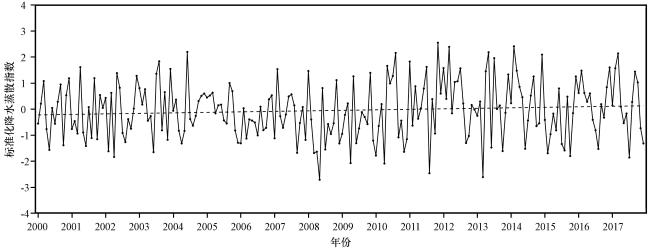
本文主要关注对象是与气象干旱密切相关的水汽输送, 而短期内降水不足引发的气象干旱和月尺度的SPEI关系最为密切(Liu et al, 2017), 因此本文绘制了2000 -2017年月尺度SPEI的时间序列以显示干湿状况的演变特征。同时根据SPEI数值确定干旱(湿润)事件: 当SPEI值首次降至0以下(升至0以上)(该月份计入事件周期), 并且随后值为-1或更小(随后值为1或更大), 确定为干旱(湿润)事件的开始, 当SPEI值返回正值(负值)时(该月份不计入事件周期), 事件结束。此外, 干湿事件的一些相关衡量标准计算如下(Tan et al, 2015): 事件期间SPEI的绝对值总和代表了该次事件的严重性, 而严重性和持续时间的比值为该次事件的强度。
4.2 极端干湿条件下到达若尔盖区域的水汽输送路径分析
干旱主要表现为降水低于正常水平, 而降水不足通常与水汽输送的变化有关(Liu et al, 2021)。为了分析水汽输送的变化和干湿变化的关系, 本文利用FLEXPART模式对该地区极端干湿条件下的水汽后向轨迹情况进行模拟。水汽输送的变化与气象干旱紧密相关, 而SPEI-1最能反映气象干旱的情况(Liu et al, 2017), 所以本文根据SPEI-1选择极端情况的月份进行模拟。SPEI-1捕捉到的最干旱的一个月是2008年5月, SPEI-1值为-2.71, 属于极端干旱的情况, 以此为基础, 结合4.1的分析结果, 选择2004年6月作为极端湿润的代表, 该月SPEI-1值为2.2, 属于极端湿润的情况。使用K-means聚类算法对FLEXPART模式模拟的水汽输送轨迹进行聚类分析, 聚类数选择为50。
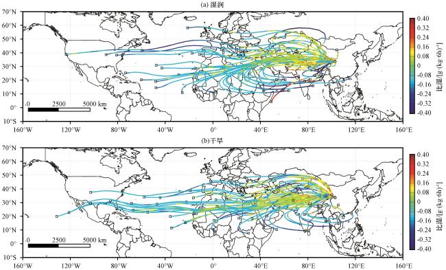
若尔盖区域是受西风和西南季风共同影响的区域, 综合对比两个时期的水汽输送路径可以发现, 干旱时期的西风作用更强, 而携带阿拉伯海以及孟加拉湾等地水汽的西南季风减弱, 从而减少了南北水汽输送, 与之相反, 湿润时期的西风作用减弱, 从图3 (a)可以发现自西向东的水汽输送路径更为分散, 而南北水汽输送的作用则要远强于干旱时期。王可丽等(2006)指出黄河源少雨年, 西风风速加强, 西南季风减弱, 黄河源大气水分含量减少, 多雨年则相反。刘彩红等(2009)认为黄河源区多雨年高空辐散, 低空辐合, 有利于南北水汽输送, 少雨年高空辐合, 低空辐散, 这种情况下, 被下层气流控制, 不利于南北水汽输送。孙立群等(2019)在其研究中指出黄河源的降水与西风指数成显著负相关, 西风的增强会减少南北水汽输送, 从而导致降水水减少。这些结论都与本文的研究结果较为一致。
4.3 潜在水汽源地分析
上文分析了极端干湿条件下到达若尔盖区域的水汽输送路及其输送过程中的水汽变化, 为了更清晰的表述可能的水汽蒸发源地, 在本节将输送路途中的比湿信息网格化, 然后利用3.3节中描述的方法识别水汽蒸发源地的分布和强度, 从而获取湿润时期和干旱时期水汽源地的空间分布信息。
如图4 面积平均的蒸散发和降水差值所示, 在湿润时期, 主要的水汽源地主要出现在阿拉伯海北部到巴基斯坦一带, 喜马拉雅山南麓西段到印度半岛东北部一直到孟加拉湾一带, 喜马拉雅山北侧雅鲁藏布江一带, 以及青藏高原东侧祁连山脉-横断山脉一带包括四川盆地。干旱时期的水汽源地则主要分布在青藏高原北部, 祁连山脉-横断山脉, 喜马拉雅山北侧雅鲁藏布江一带, 巴基斯坦东北部以及印度半岛东北部。与湿润时期相比, 干旱时期青藏高原北部出现了明显的水汽源地, 最北可达阿尔泰山, 但是喜马拉雅山脉南麓西段和孟加拉湾的水汽源地消失, 只剩下印度半岛东北部的水汽源地, 但强度也有所减弱。湿润时期贯穿巴基斯坦全境直达阿拉伯海北部的水汽源地在干旱时期大幅减弱, 只剩巴基斯坦东北部有微弱的水汽源地存在。此外, 值得注意的是, 在两个时期若尔盖区域本身都是主要的水汽源地。
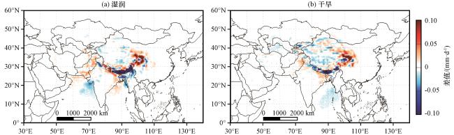
结合图3 的水汽输送路径情况可以发现, 湿润时期南北水汽输送路径更多, 作用更强, 从孟加拉湾、 阿拉伯海的输送的水汽路径更多, 因此湿润时期在孟加拉湾、 阿拉伯海北部出现了明显的水汽源地, 在其输送到若尔盖区域的过程中, 也经历了更多的蒸发和降水过程。从图4 可以发现, 高原南部区域, 特别喜马拉雅山一带, 湿润时期表现出了更明显的水汽源地以及降水区域。干旱时期, 西风作用加强, 南北水汽输送减少, 水汽源地分布较湿润时期要更加偏北, 高原北部出来了大量明显的水汽源地, 而湿润时期偏南的水汽源地都已减弱甚至消失。
4.4 不同水汽源地的贡献率
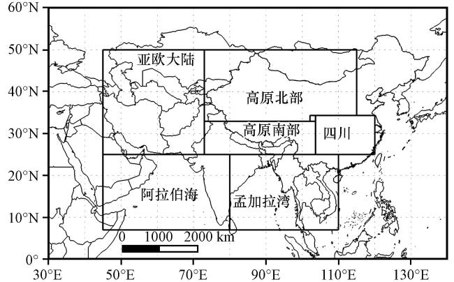
以上研究展示了对若尔盖区域降水有贡献的水汽蒸发源地以及其在不同干湿阶段的变化, 但是不同水汽源地对降水的贡献大小并没有得到清楚的定量表述, 并且水汽从水汽源地输送进入若尔盖区域的途中会经过多次降水、 蒸发导致的水分变化, 特别是若尔盖区域位于青藏高原, 高原独特的地形会使水汽爬坡从而形成降水, 使输送的水汽减少。因此为了准确表述不同水汽源地对降水的贡献以及其在不同干湿阶段的变化特征, 首先依据识别出来的水汽蒸发源地结果, 将代表性的水汽源地划分为如图5 所示的几个区域, 分别是青藏高原北部区域(32.93°N -50°N, 73°E -115°E), 青藏高原南部区域(25°N -32.93°N, 73°E -103.65°E), 亚欧大陆区域(25°N -50°N, 45°E -73°E), 阿拉伯海区域(6°N -25°N, 45°E -80°E), 孟加拉湾区域(6°N -25°N, 80°E -110°E), 四川区域(25°N -34.32°N, 103.65°E -120°E)以及若尔盖区域(32.93°N -34.32°N, 102.13°E -103.65°E)计算了不同区域的水汽蒸发对降水的贡献大小。
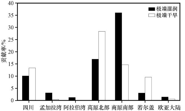
其结果如图6 所示, 其中孟加拉湾、 阿拉伯海以及欧亚大陆3个区域的贡献率在两个时期都比较低, 但在湿润时期的贡献率相对更高, 3个区域在湿润时期的贡献率分别是3.14%, 1.26%, 1.45%, 而3个区域在干旱时期的贡献率则相对较低, 都不足1%。四川、 高原北部以及高原南部3个区域则在两个时期都是主要的水汽源地区域, 贡献了大部分的水汽, 贡献率都较高, 3个区域在湿润时期的贡献率分别是10.09%, 16.97%和35.99%, 而在干旱时期的贡献率分别是13.35%, 28.35%和14.67%。因为干旱时期西风作用增强, 南北水汽输送减弱, 导致了孟加拉湾以及阿拉伯海等区域的贡献率在干旱时期减弱, 而湿润时期这些区域的水汽贡献率虽然高于干旱时期, 但由于距离若尔盖较远, 并且输送路程中地形复杂, 发生了多次蒸发降水过程(图4 ), 因此来自孟加拉湾以及阿拉伯海的水汽贡献率仍然较低。但是由于湿润时期来自孟加拉湾以及阿拉伯海的水汽输送路径数量增多, 作用增强(图3 ), 加上其输送路程中多次蒸发过程, 导致了在该水汽输送路程中的其他区域的水汽贡献率增强, 例如湿润时期高原南部的水汽贡献率是所有水汽源地中最大的, 与之相对, 干旱时期高原南部的水汽贡献率大幅降低, 此时水汽贡献率最大的区域是高原北部。此外若尔盖局地蒸发造成的贡献率不容忽视, 其贡献率在干湿两个时期都要高于孟加拉湾、 阿拉伯海和欧洲大陆3个区域的水汽贡献率, 并且该区域干旱时期的贡献率明显高于湿润时期, 在干旱时期, 该区域的局地贡献率为9.58%, 接近该时期高原南部的贡献率, 这都表明了干旱时期温度升高导致地面蒸发增加, 进而导致降水增加, 使得局地的水汽贡献率更高。
5 结论与讨论
本文基于拉格朗日轨迹模型FLEXPART模拟了根据SPEI选择的极端干湿状况下的水汽输送情况, 然后根据模拟结果对水汽输送路径、 水汽蒸发源地及不同源地对降水的贡献率进行了分析, 得到以下结论:
(1) 若尔盖区域的水汽输送主要是受到西风带影响的自西向东的输送轨迹以及受到西南季风影响的南北输送路径。其中前一条轨迹在干旱时期起到主要作用, 而第二条轨迹在湿润时期发挥更重要的作用。
(2) 两个时期的水汽源地表现出了明显差异, 湿润时期的水汽源地主要出现在高原以南的区域, 包括巴基斯坦、 阿拉伯海北部一直到孟加拉湾一带, 以及青藏高原东侧祁连山脉-横断山脉一带。干旱时期的水汽源地则主要分布在青藏高原北部, 祁连山脉-横断山脉, 喜马拉雅山北侧雅鲁藏布江一带。
(3) 湿润时期最主要的水汽源地为高原南部, 而干旱时期最主要的水汽源地是高原北部, 此外孟加拉湾、 阿拉伯海以及欧亚大陆的贡献率在湿润时期更高, 而四川区域以及若尔盖本身的贡献率在干旱时期更高。
许多学者进行了水汽输送的工作(陈亚玲等, 2022; 王美月等, 2022), 但大多工作都是针对降水异常展开的, 而水汽通过降水的形式进入地表, 继而以蒸发、 下渗等形式进行循环, 其中一部分进入土壤, 使陆表干湿状态发生变化, 因此本文跳过具体的降水事件, 针对降水事件带来的陆表干湿状态, 基于SPEI的计算结果提取了陆表极端的干湿状态并对不同状态下的水汽输送特征进行模拟分析, 从空中水汽输送的角度分析干湿演变机制, 这是我们与前人工作的不同。结果表明输送到若尔盖的水汽主要受西风带和西南季风影响, 并且在干湿两个时期表现出了明显的差异, 这一定程度上解释了若尔盖区域的干湿演变机制, 但是SPEI是基于降水和蒸发计算得到, 所以单纯的从降水角度展开的分析不足以完全解释其机制, 因此后续还将结合地面蒸发, 进行进一步工作。相对传统的水汽通量分析或者欧拉模型等研究方法, 本文使用拉格朗日模型进行水汽输送的模拟, 可以更加清楚的展示水汽输送轨迹, 定量化表示潜在水汽源地的水汽贡献率, 但该方法主要缺点是无法将蒸发和降水分开, 在模拟水汽输送过程中, 将降水和蒸发视为一个整体, 通过比湿的变化获得降水和蒸发的数值, 这种方法会导致结果的不精确, 因此后续还将结合实际观测改进结果。此外本文使用FNL资料驱动模型, 该数据资料在青藏高原存在一定的不确定性, 加上模式本身存在一定的误差, 所以模式模拟的结果和实际也会存在一定的差别, 因此在后续工作中还将结合不同的数据资料, 利用不同的数值模式进行研究, 并结合实际观测进行综合分析。