
1 引言
地形降水是受湿气流和地形相互作用影响的雨、 雪及其他降水现象(Houze, 2012; 钟水新, 2020)。湿气流过山时, 受到地形挤压、 重力波等因素的影响, 山脉上游及下游大气发生向上或者向下的垂直运动, 可能会诱发新的降水, 或者改变原有的降水系统结构(Hou et al, 2014; Lu et al, 2021; 王思懿等, 2022)。研究表明, 地形影响降水系统的强度和分布范围, 这主要取决于山脉的高度及形状、 过山气流的运动、 湿空气热动力变化等的共同影响(Zhang et al, 2018; 乌日柴胡等, 2019; Morales et al, 2021)。湿空气在盛行风作用下经过山脉时, 受风场和地形抬升共同影响, 降水多发生在山脉的迎风坡一侧, 导致山顶附近的降水增强(Alexander et al, 2017; Agel and Barlow, 2020; 刘艳霞等, 2024)。
山谷风对影响近地面的热动力条件、 大气环流和降水数值模型优化等起着至关重要的作用(Rotunno and Houze, 2007; Akinsanola et al, 2020)。李嗣源等(2023)认为青藏高原东侧四川盆地和平原的夜间降水峰值是受海拔较高的青藏高原与海拔较低的平原盆地构成的大尺度“山谷风”环流影响产生。Barros and Lang (2003)认为地形影响降水的最本质原因是地形与周围地区下垫面的不均匀受热, 造成山地与周围平原或盆地之间降水日变化特征存在差异的主要影响机制可能是山谷风环流。Houze et al (2007)研究发现, 山谷风可能在触发降水机制中发挥了重要作用。Panziera et al (2010)的研究发现风速对降水强度的影响强于静力稳定度。Jing et al (2018, 2019)通过对美国西部地形降水分布特征分析得出, 影响降水分布的主要因素是低层风速。
伊犁河谷位于天山西部, 境内地势起伏悬殊, 西风带湿润水汽受地形影响抬升凝结, 形成丰沛降水, 伊犁河谷是中亚干旱区降水量最丰富的地区, 被誉为“中亚湿岛”。前人对伊犁河谷地区降水特征、 影响系统和水汽来源等进行了大量研究 (Lu et al, 2023)。如Li et al (2017) 认为伊犁河谷复杂的地形造成了该地区受热动力驱动的山谷风及地形汇聚作用等的影响, 造成该地降水时空分布极不均匀, 平原地区年均降水量为235~526 mm, 山区则集中在600~800 mm, 伊犁河谷降水量远大于周边区域。Bothe et al (2012)指出天山地区的水汽主要通过中纬度盛行西风从更高纬度地区输送而来。Li et al (2020)基于地面气象观测站点的观测资料统计发现, 伊犁河谷地区夏季降水量和降水频率随地形抬升而增大, 降水峰值出现在傍晚至夜间, 地面多为偏西风。
伊犁河谷呈向西的“喇叭口形状”, 特殊地形有利于在山地迎风坡形成降水, 使该地区成为研究山谷风和地形对降水影响的重要区域, 目前针对伊犁河谷地区的降水主要是利用地面气象站点资料开展研究, 由于气象观测站分布稀疏, 存在较大的观测盲区, 难以对伊犁河谷复杂地形中的降水系统进行有效探测, 因此星载测雨雷达是观测该地区降水系统的唯一有效手段(Kumar et al, 2017; Zhang et al, 2018; 沈程锋和李国平, 2022)。新一代全球降水测量卫星GPM(Global Precipitation Measurement)上搭载的主动遥感测雨雷达DPR(Dual-frequency Precipitation Radar)可以实现降水系统的宏微观结构三维观测, 这为研究该地区的降水系统提供了技术支撑。风场控制了水汽的输送和积累, 是降水研究的重要组成部分(Romatschke and Houze, 2010; Rasmussen and Houze, 2011; 魏栋等, 2021)。文中结合GPM/DPR资料和ERA5的近地表风场数据, 识别了夏季伊犁河谷地形降水系统, 厘清了谷风和山风降水系统的宏微观特征差异, 揭示了山谷风和地形对降水系统结构的影响, 探究了伊犁河谷地区的降水机制, 为科学评估该地区人工增雨(雪)潜力奠定基础。
2 数据来源和方法介绍
2.1 降水系统识别
全球首部星载测雨雷达(GPM/DPR)由Ku波段(13.6 GHz, KuPR)和Ka波段(35.5 GHz, KaPR)组成, 其中KuPR与TRMM PR相似, 识别降雨率灵敏度为0.5 mm·h-1, 在观测强降水方面更可靠, KaPR对弱降水(识别降雨率灵敏度为0.2 mm·h-1)更灵敏, KuPR的扫描方式为Normal Scan(NS), 观测幅宽约245 km, KaPR具有两种观测模式: Matched Scan(MS)和High sensitivity Scan(HS), 观测幅宽约125 km, DPR的降水反演算法包含单频和双频反演算法, 双频反演算法中包含有粒子谱产品(Hamada and Takayabu, 2016)。为了获取更多的降水系统宏微观信息, 文中选取了双频反演产品GPM 2ADPR开展相关研究。
文中使用了2014 -2021年夏季(6 -8月)的2ADPR降水产品, 其水平分辨率为5 km, 垂直范围分辨率为250 m, 2ADPR包含从22 km到地表的降水三维结构信息, 主要提供了已衰减订正的雷达反射率因子(Z)、 近地表降水率(R)、 雨顶高度(STH)、 质量加权平均直径(D m)和粒子数浓度(dBN w)雨滴谱参数等。GPM/DPR持续稳定运行多年, 测量数据经过与地基测雨雷达、 雨量计和二维雨滴谱仪等进行了严格的内外部定标和交叉验证, 均一性好, 可靠性高(Le and Chandrasekar, 2019)。
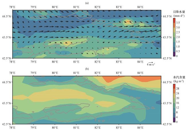
降水系统(Rain Cell, RC)是自然界中降水的最基本存在形式(Fu et al, 2018)本文中, 我们使用国际上通用的连通域识别法, 将空间上连续的2ADPR降水像元识别为RC(Pan et al, 2021)。在本文的统计分析中, 主要考虑了20个或以上像素的RC。由于伊犁河谷地区地面气象站点和地基测雨雷达分布较稀疏, 选择RC范围大小的标准是因为分布范围较大的降水系统易于在后续研究中找到对应的地面气象观测资料进行对比验证, 伊犁河谷地形和气象站点分布(图1), 图2给出了伊犁河谷平均日降水量和大气柱水汽含量分布, 可以看出降水量大值区主要分布在山区, 水汽则集中在河谷低层。
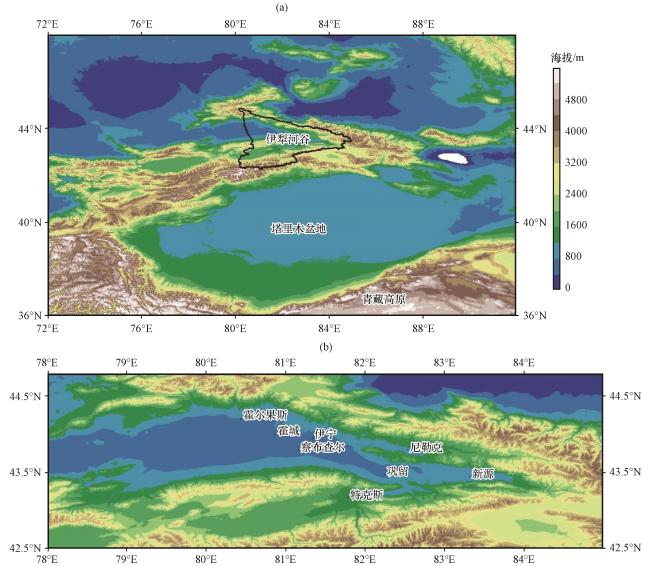
图1 伊犁河谷地形(a, 单位: m)及气象站点分布(b)Fig.1 Ili River Valley Topography (a, unit: m) and distribution of meteorological stations (b) |
2.2 研究区域地表风类型
文中使用了ERA5(ECMWF Re-analysis)再分析数据集10 m高度的平均地表风速和风向数据, 在以往的统计研究中, 平均风场被简单地计算为整个降水时间内区域的平均值, 这考虑了许多非降水区域。为了减少非降水区域的影响, 本研究将RC的有效像元与地表风数据进行时空匹配, 获得每个DPR像元对应ERA5的约12.5 km和 3 h范围内最接近地表风格点的数据, 再者计算每个RC的平均风速和风向。风场是水汽输送、 降水分布研究中的重要参量(Galewsky et al, 2008)。白天山坡向阳面受到太阳辐射加热, 温度高于周围同高度大气层, 暖而不稳定的空气由谷底沿山坡爬升; 夜间山坡辐射冷却降温, 温度低于周围同高度大气层, 冷空气沿山坡下滑。对于沿山谷轴的气流, 即指常见的谷风和山风, 白天沿山坡爬升的谷风, 夜间沿山坡下滑的山风。山谷环流交替出现使昼夜风速和风向呈现有规律的变换。在复杂地形条件下, 需要根据研究区域的位置来判断谷风和山风的风向, 山谷风不仅受热力影响, 其起止时间和风速大小还受山谷逆温、 复杂地形、 植被覆盖、 土壤湿度以及太阳辐射等因素的影响(Jin et al, 2016)。伊犁河谷地区由局地山风和谷风环流所形成的降水存在明显的差异。文中谷风和山风型降水的分类方法如下: 首先本研究将风场资料分解为u、 v分量, 称为实际风, 将某日逐时u、 v分量求均值得到 、 , 作为背景场风; 利用逐时实际风u、 v减去背景风 、 , 得到逐时局地风u′、 v′, 代表山谷风(郑祚芳等, 2018; 吴进等, 2022)。针对山谷风观测数据, 将10:00 - 20:00由山谷流向山坡/山顶的气流统计为谷风, 00:00 -06:00由山坡/山顶流向山谷的气流统计为山风(王倩倩等, 2022), 统计得出伊犁河谷地区山风/谷风的空间分布特征。文中选取了12个谷风型和14个山风型降水系统。
3 结果分析
本文首先基于地表风对伊犁河谷的降水系统进行了分类, 然后对典型的山谷风降水系统进行了个例分析, 最后对每一类典型降水系统的结构特征进行了统计研究。
3.1 个例分析
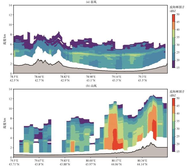
图3给出了两类RC典型个例的R和风场信息, 其中第1类降水是2014年8月18日19:08发生在伊犁河谷南坡海拔2~4 km处的谷风类降水系统, 如图3(a)所示, 对应地表风的水平风切变较小, 存在一个强降水中心, 达到了5 mm·h-1以上, R在上坡风的作用下, 自谷底向山坡随高度逐渐增强。第2类降水[图3(b)]是2015年7月11日03:45主要发生在河谷平原和北坡上的山风类降水, 受强烈的下坡风的控制, 对流性降水带相当狭窄, R与地形高度较吻合, 山坡上的降水强度大于毗邻平原, 强降水中心主要分布在5~10 mm·h-1。沿图3中A-B线对降水系统的Z进行垂直截面, 如图4所示, 其中谷风降水的Z[ 图4(a)]主要分布在距离9 km范围内, STH和Z在上坡风的影响下显著增加, 存在较明显的下挂回波(黄美元和洪延超, 1984), 这与R存在较好的对应, 剖面中可见明显的融化层亮带, Z达到了35~45 dBZ。山风类降水[图4(b)]的最高STH超过12 km, 表明该位置为强对流云(Pan et al, 2021), 相邻像元的Z值迅速减少, 云中出现显著的对流泡, 与地表降水对应关系较好, Z最大值超过了45 dBZ。
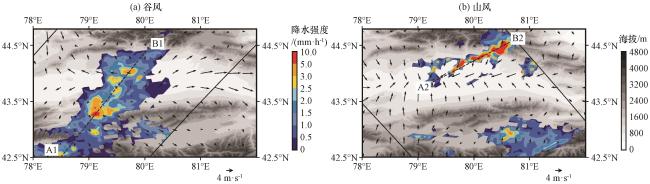
图3 山谷风RC的R分布(a)谷风, (b)山风; 虚线为剖面位置, 黑色实线为轨道宽度, 矢量箭头为风场矢量(单位: m·s-1)Fig.3 R distribution of mountain-valley wind RC.(a) valley wind, (b) mountain wind.The dotted line is the section position, the solid black line is the track width, and the vector arrow represents wind field vector (unit: m·s-1) |
3.2 降水系统的时空分布与地表风特征
本节主要对RC发生的位置、 时间和对应地表风进行了统计分析。谷风型降水空间位置和对应地表风分布表明[图5(a), 图6(a)], 受局地热力变化的影响, 谷风类RC在伊犁河谷南部和东部山麓迎风坡区域分布更为集中, 由于在上坡风和“喇叭口”地形抬升作用下沿斜坡上升的河谷底层暖湿气流在迎风坡局部凝结产生降水, 这也验证了谷风对降水触发位置的影响。受下坡风影响的山风类降水[图5(b), 图6(b)], 多出现在河谷平原地区, 当受下坡气流控制, 易在河谷底层形成弱的辐合, 导致湿空气上升凝结成降雨。伊犁河谷受昼夜循环山谷风影响的降水系统特征与Houze et al (2007) 研究得出的降水模型较为一致, 后者认为地形抬升和昼夜的加热和冷却可能在触发喜马拉雅中部地区的降水中发挥了作用。综上分析, 伊犁河谷的RC主要集中在河谷南部和东部, 这种现象与“喇叭口”的特殊地形特征有关(Veals et al, 2019)。
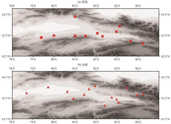
图5 山谷风RC的空间分布(a)谷风, (b)山风; 方块和三角形分别为谷风和山风类降水Fig.5 Spatial distribution of mountain-valley wind RC.(a) valley wind, (b) mountain wind.Blocks and triangles represent valley and mountain wind precipitation respectively |
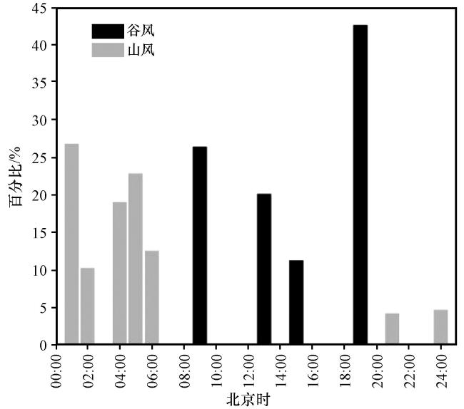
山谷风环流存在明显的日变化特征。在图7中, 谷风RC多发生在午后和傍晚(12:00 -20:00), 降水多发生在午后谷风控制时段, 峰值出现在19:00左右。这主要由于午后的地面感热最强, 低层空气被加热上升, 促进了降水系统的形成。此外山谷风环流也是山区夜雨形成的主要机制, 此时显热(感热)强迫被抑制。山风RC主要出现在夜间和清晨时段(01:00 -06:00), 峰值出现在01:00附近, 此时山风最强。地面显热在午夜被抑制得最大, 随着气温和饱和比湿降低, 水汽通过相变产生降水系统。所有降水系统与地面显热(增强或抑制)高度相关(Whiteman et al, 2000)。白天辐射加热叠加地形抬升作用导致午后山坡地区降水增加, 而夜间和清晨河谷平原和浅山区的水汽汇聚形成降水(Neiman et al, 2002)。Li et al (2020) 分析发现伊犁河谷地区不同降水强度-频次分布的台站降水具有不同的日变化特征, 强降水发生频率相对高的地区, 降水易发生于午后-傍晚时段, 而弱降水发生频率相对高的地区, 集中在夜间-清晨时段。相关统计结果与本文较为一致。
3.3 不同风场条件下的降水特征
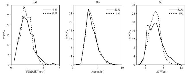
本节的分析侧重于通过对不同参数的统计分析, 以量化山谷风降水的特征差异, 图8显示了三个参数(风速、 R和STH)的概率密度分布(Probability Density Function, PDF)。就地表风速而言[图8(a)], 谷风RC平均风速是0.79 m·s-1, 集中在0.1~2.5 m·s-1的范围内, 山风RC的平均风速为0.74 m·s-1, 超过0.1~2.0 m·s-1范围的概率密度迅速下降。两类降水对应的风速超过1.5 m·s-1占比分别为5.6%和2%。R[图8(b)]的PDF分布比风速要简单一些, 谷风和山风RC的R平均值分别为1.32 mm·h-1和1.15 mm·h-1, 大于5 mm·h-1的占比为1.86%和1.79%。这些统计结果与近地面气流湿度呈正相关, 山谷风降水的水汽来源主要为河谷低层潮湿的气流携带足够的水汽, 或者通过午后蒸发累积丰富的水汽, 在山谷风的引导下产生降水过程。下坡风也会伴随强降水事件, 可能与低空急流的辐合等有关(Soderholm et al, 2014)。通过图8(c)可以看出两类降水的STH集中在3.0~10 km, 平均值分别为5.90 km和5.72 km。谷风类降水的STH的概率密度为一个双峰结构, STH大于8 km的百分比分别为6.67%和3.71%, 这一比例范围与强降雨的比例较为一致。研究表明山谷风降水STH与R呈正相关。
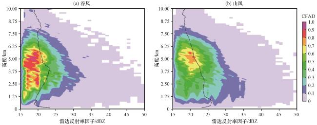
等高频率分析(Contoured Frequency by Altitude Diagram, CFAD)方法可以有效地揭示降水系统的垂直结构特征( Yuter and Houze, 1995), 两类RC的0 ℃层高度在3.5~4.5 km, 不同降水垂直结构存在明显差异(图9)。山风RC在0 ℃层高度以上冰相区域的Z较小, 云中冰粒子偏少, 谷风RC有较清晰的0 ℃层亮带, 主要表现为CFAD等值线明显向更大的Z值凸出, 在3.5~4.5 km附近达到最强, 此后, 随着高度的下降CFAD等值线逐渐朝向较小的Z方向移动, 这主要表明, 在0 ℃层高度附近融化的冰粒子产生更强的雷达反射率(Houze et al, 2007)。在0 ℃层高度以下的液相区域, 降水粒子通过碰并聚合增长和自发破碎落到地面上。谷风RC在液相区域的Z值较大, R较强, 而山风降水在冰相反射率因子更高, 而在液体区反射率要弱得多, 对应的R偏弱, 这表明该液相区域的Z大小与R呈正相关, 这种现象可能与地面湿度有关(Houze et al, 2007)。
3.4 不同风场条件下地形对降水的影响
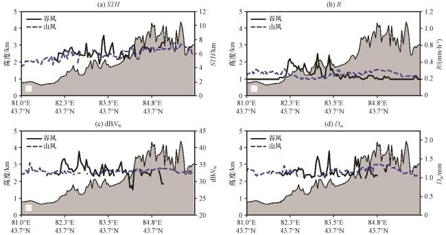
为深入认识山谷风RC的宏微观物理特征, 本节主要对伊犁河谷纬向(43.7°N)和经向(80.5°E)截面中降水的STH、 R、 D m和dBN w参数进行了对比分析。其中图10(a)和图11(a)为两类降水的STH变化, 在山坡区域1~3 km高度范围内谷风RC的STH沿地形高度升高逐渐增加, 在2~3 km附近STH出现隆起(6~9 km), 而后迅速下降, STH出现先升高后降低的现象与Zhang et al (2018)研究相一致, 后者认为在地形抬升作用下云中水汽凝结产生降水, STH不断增加, 随着云中液水含量的不断损耗STH逐渐下降。山风降水STH小于6.5 km, 随地形变化不明显, 可能是由于上升气流被下坡风抑制。在R变化特征[图10(b), 图11(b)]中, 平原地区山风降水的R(0.65 mm·h-1)是山坡区域(0.35 mm·h-1)的1.86倍。谷风降水的R随山脉高度增加不断增强, 在2~3 km高度处达到峰值0.6~0.7 mm·h-1, 其后随地势高度的增加而逐渐下降, 由于河谷地表的湿度和潜热通量大而富集了大量水汽, 在上坡风、 局地热力过程等的影响下, 强降水主要分布在2~3 km高度的山坡附近(Fu et al, 2018)。新疆地区干燥的低层空气, 空气柱中水汽较少的原因, 降水较中东部偏小(Li et al, 2021)。
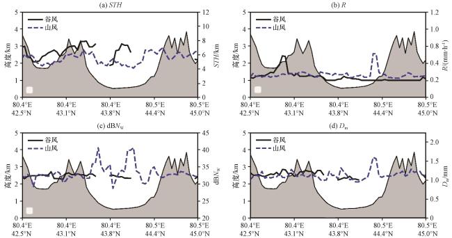
图10 山谷风降水不同参量径向平均分布(a)STH, (b)R, (c)dBN w, (d)D m; 灰色阴影表示地形高度Fig.10 Radial average distribution of different parameters of mountain-valley wind RC.(a) STH, (b) R, (c) dBN w, (d) D m.The grey shaded denotes terrain height |
统计发现谷风和山风RC的dBN w分别在28~39和29~40之间, 如图10(c)和11(c)所示, 山风降水dBN w在经向截面的平原地区较大, 谷风降水dBN w在经向截面山坡区域2~3 km处存在峰值(36~39), 谷风RC的dBN w比山风偏小3%左右。图10(d), 图11(d)显示了D m沿地形横截面的分布情况, D m主要集中在1.0~1.75 mm。谷风降水在经向截面迎风坡区域的D m出现明显的突起(1.5~1.75 mm)较平原地区(1.2~1.3 mm)大30%~35%, Zwiebel et al (2016)认为低层湿空气在沿着山坡地形爬升的过程中, 促进液相区域的碰并生长过程, 导致在山坡局部区域D m较大。在纬向截面山风RC的D m大值区集中在1.25~1.5 mm。通过对比发现谷风降水的平均D m(1.63 mm)较山风(1.38 mm)偏大18.1%。这可能是因为山风RC垂直结构较谷风RC的液相区域Z较低, 当冰粒子下降到较低的干燥层时, 大液滴破碎蒸发导致近地面dBN w偏多而D m较小(Zwiebel et al, 2016)。
综上所述, 谷风RC在径向较纬向截面的R、 STH、 D m、 dBN w参量普遍偏大, 在迎风坡地区谷风降水的各参量在迎风坡海拔2~3 km处出现极大值。山风RC宏微观参量大值区集中在纬向截面的河谷平原地区。在山谷风, 局地热力作用等的影响下, 促进了地形云内的微物理过程, 使局部湿空气抬升凝结产生碰并-聚合过程, 导致山风RC在河谷平原和谷风RC在迎风坡局部区域出现强降水(Houze, 2012)。
4 结论
为了更好地了解伊犁河谷的降水过程, 文中利用了GPM/DPR数据和ERA5地表风资料, 通过个例研究和统计分析了山谷风RC宏微观参量的水平分布、 垂直结构以及与“喇叭口”地形的关系, 探讨了不同降水的形成机制。主要结论如下:
(1) 受上坡风影响谷风RC主要发生在伊犁河谷南部和东部山麓迎风坡区域, 在下坡风作用下山风类降水多出现在河谷平原地区, 谷风RC多发生在午后-傍晚(12:00 -20:00), 主要出现在19:00左右。山风RC主要出现在夜间-清晨时段(01:00 - 06:00), 出现时段集中在01:00附近, 山谷风RC与地面显热(增强或抑制)高度相关。
(2) 谷风RC平均风速(0.79 m·s-1)比山风(0.74 m·s-1)大6.8%, R和STH平均值分别是1.32 mm·h-1、 1.15 mm·h-1和5.90 km、 5.72 km, 降水的STH与R呈正相关。两类RC的融化层高度在3.5~4.5 km, 谷风RC比山风在0 ℃层以下的液相区域Z值更大, R值偏强, 表明有效的碰并过程会导致较大的降水强度, 得出液相区域Z值大小与R为正相关。
(3) 谷风RC宏微观参量在地形抬升作用下, 在山区2~3 km处出现极大值, 可能与迎风坡大雨滴粒子增多有关, 其后随地势高度的继续增加而逐渐减小, 谷风RC在径向截面迎风坡的STH、 R、 D m、 dBN w均值分别比纬向河谷平原区域大12.5%、 20%、 13.3%和21.2%。山风RC的各参量大值区集中在纬向截面的河谷平原地区。
(4) 统计发现径向截面谷风RC的STH和R最大值(9 km和0.7 mm·h-1)比纬向截面山风RC(6.5 km和0.6 mm·h-1)大28.6%和16.7%, 谷风RC的平均dBN w(33.5)比山风(34.5)偏小近3%, 而前者平均D m(1.63 mm)较后者(1.38 mm)大18.1%。由于山风RC低层液水含量偏小, 当雨滴下降到近地面的干燥层时, 大液滴破碎蒸发导致dBN w偏多而D m较小。
在地形复杂的伊犁河谷地区降水宏微观结构的演变是十分复杂的, 本文初步讨论了伊犁河谷山谷风环流引导的地形降水特征及其成因。因客观原因限制, 本研究存在一些不确定性和局限性, 其中不同降水类型对2ADPR反演算法性能的影响待评估。此外, 本研究识别出的样本量偏少, 存在一定的局限性。今后将重点分析层云和对流云降水等不同降水类型对星载测雨雷达反演算法适用性, 同时收集整理更多的降水过程, 开展进一步研究。