
1 引言
2 案例及实验设计介绍
2.1 案例分析
表1 低空风切变个例基本信息Table 1 Basic Information of Low-level Windshear Cases |
| 日期(年-月-日) | 世界时 | 位置 | 高度/m | 起降阶段 |
|---|---|---|---|---|
| 2021-04-15 | 06:31 | 距36号跑道入口1.0 km | 91.44 | 着陆 |
| 2021-04-16 | 03: 30 | 全跑道至18号跑道向北3.0 km | 152.40~752.80 | 起飞 |
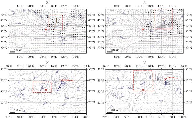
图1 2021年4月15日06:00(a, c)和16日03:00(b, d)500 hPa(a, b)与地面(c, d)天气图蓝色实线为等位势高度线, 红色线为等温线, 黑色风羽指代风向风速, 红色五角星指代中川机场位置, 红色虚线框内为影响机场的主要天气系统, 棕色线表示槽线 Fig.1 Weather charts at 500 hPa (a, b) and the ground (c, d) for 06:00 on 15 (a, c) and 03:00 on 16 (b, d) April, 2021.The blue solid lines representing contours of geopotential height, red lines representing isotherms, black wind barbs indicating wind direction and speed, a red five-pointed star indicating the location of Zhongchuan Airport, and the major weather system affecting the airport enclosed within the red dashed box, The brown line represents the trough line |
2.2 数据来源和研究区概况
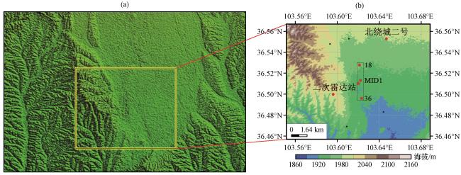
图2 原始地形tif文件研究区域范围(a)、 地形(彩色区, 单位: m)及观测站点分布状况(b)黑色断线框表示机场跑道范围, 红色圆点为观测站点位置, 五角星为中川机场中心位置 Fig.2 Original terrain tif file about the scope of the study area (a) and the topographic (color area, unit: m) and observation station distribution in the study area (b).The black dashed box indicates the airport runway area, black dots indicate the locations of observation stations, and the five-pointed star represents the central location of Zhongchuan Airport |
表2 观测站点名称与经纬度位置Table 2 Names and latitude and longitude locations of observation stations |
| 序号 | 站点名称 | 经纬度坐标 |
|---|---|---|
| 1 | 北绕城2号 | 103.647°E, 36.553°N |
| 2 | MID1 | 103.622 °E, 36.513°N |
| 3 | 二次雷达站 | 103.596°E, 36.500°N |
| 4 | 18 | 103.622°E, 36.528°N |
| 5 | 36 | 103.622°E, 36.496°N |
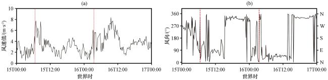
图3 2021年4月15日00:00至17日00:00 MID1站点的风速(a)、 风向(b)变化黑色实线为观测数据, 红色虚线指代低空风切变发生时间 Fig.3 Variations in wind speed (a) and direction (b) at MID1 Station from 00:00 on April 15 to 00:00 on April 17, 2021.Solid black lines represent observed data, dashed red lines indicate the occurrence time of low-level windshear |
2.3 模式参数设置及试验设计
2.3.1 WRF模式
表3 WRF模式参数化方案设置Table 3 WRF mode parameterization scheme Settings |
| 物理过程 | 参数化方案 | 备注 |
|---|---|---|
| 微物理过程(mp_physics) | Thompson (Thompson et al, 2008) | 包含冰、 雪和霰过程的适用于高分辨率模拟的方案。 |
| 积云对流过程(cu_physics) | Kain-Fritsch (Kain, 2004) | 使用有下沉气流的深对流和浅对流次网格方案。 |
| 近地面层过程(sf_sfclay_physics) | Revised MM5 Monin-Obukhov (Jiménez et al, 2012) | 基于含有Carslon-Boland粘性底层和来自查表中的标准相似函数的Monin-Obukhov方案 |
| 陆面过程(sf_surface_physics) | Noah (Chen and Dudhia, 2001) | 统一NCEP / NCAR / AFWA方案, 含有4个不同层次上土壤温度和湿度、 积雪覆盖面积和冻土物理过程。 |
表4 WRF模式物理过程参数化方案组合Table 4 Physical process parameterization schemes in WRF mode |
| WRF参数化 方案组合 | 辐射方案 | 边界层 方案 | |
|---|---|---|---|
| 长波辐射 | 短波辐射 | ||
| S1 | RRTM | Dudhai | MYJ |
| S2 | RRTM | Dudhai | YSU |
| S3 | Goddard | Goddard | MYJ |
| S4 | Goddard | Goddard | YSU |
表5 评价指标Table 5 Evaluation indicators |
| 名称 | 公式 |
|---|---|
| 均方根误差(RMSE) | |
| 平均绝对误差(MAE) | |
| 一致性指数(IA) | |
| 相关系数(R) |
2.3.2 CFD模式
2.3.3 LSTM风速预测模型
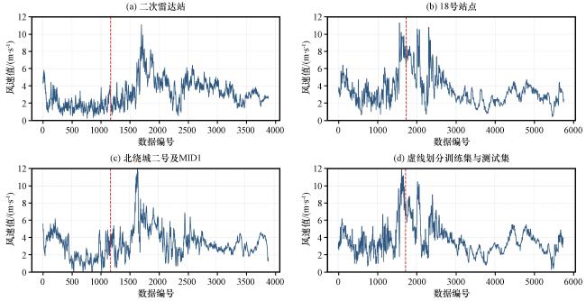
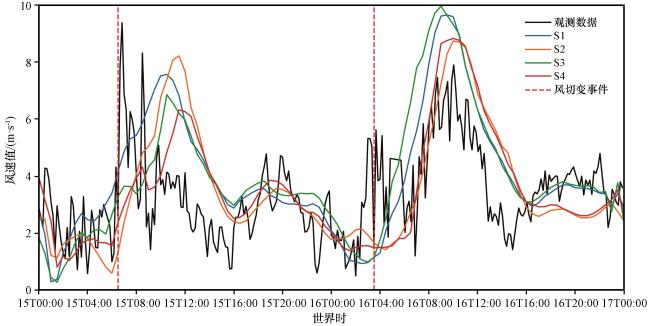
图6 WRF模式4种参数化方案组合风速模拟结果Fig.6 Combined wind speed simulation results of four parameterized schemes in WRF model |
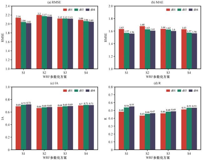
图7 WRF模式四种参数化方案组合结果评价(d02, d03, d04指代嵌套网格层数)(a) RMSE, (b) MAE, (c) IA, (d) R Fig.7 Evaluation of the Combination Results of Four Parameterization Schemes in the WRF Model (d02, d03, d04 refer to the number).(a) RMSE, (b) MAE, (c) IA, (d) R |
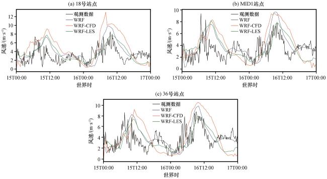
图8 WRF-LES和WRF-CFD在三个站点的10 m高度风速模拟结果对比(a)18号站点, (b)MID1站点, (c)36号站点 Fig.8 Comparison of wind speed simulation results of WRF-LES and WRF-CFD at 10 m height at three stations.(a) Site 18, (b) MID1 site, (c) Site 36 |
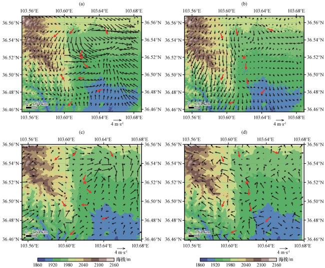
图9 2021年4月15日06:30和4月16日03:30两个时刻的WRF-CFD和WRF-LES的10 m高度水平风场对比红色五角星指代中川机场位置, 红色箭头指代观测站点风速; (a, b) WRF-CFD, (c, d) WRF-LES Fig.9 Comparison of WRF-CFD and WRF-LES horizontal wind fields at 10 m height at 06:30 on April 15 and 03:30 on April 16, 2021.Red five-pointed star refers to the location of Nakagawa Airport, red arrow refers to the wind speed at the observation station.(a, b) WRF-CFD, (c, d) WRF-LES) |
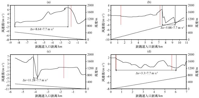
图10 2021年4月15日06:30 (a, c)和2021年4月16日03:30 (b, d)的WRF-CFD (a, b)和WRF-LES (c, d)的飞机起飞或着陆过程中的风速差对比虚线指代飞机飞行过程中的高度变化, 实线指代风速变化, 红色虚线代表遭遇低空风切变位置 Fig.10 Comparison of wind speed differences during aircraft takeoff or landing between WRF-CFD (a, b) and WRF-LES (c, d) for the times of 06:30 on April 15, 2021 (a, c), and 03:30 on April 16, 2021 (b, d).The dashed lines represent changes in altitude during the flight, solid lines represent changes in wind speed, red dashed lines indicate the positions where low-altitude wind shear is encountered |
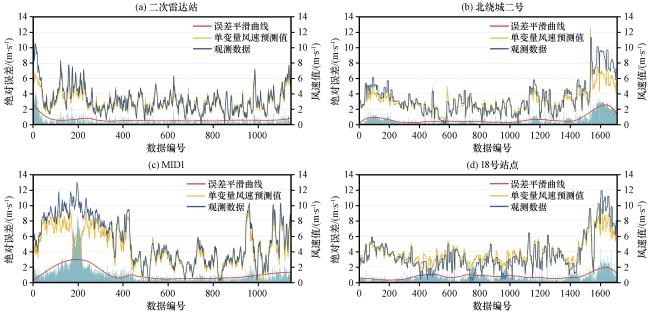
图11 单变量时间序列风速预测结果与绝对误差(a~d)依次为二次雷达站、 北绕城二号、 MID1及18号站点 Fig.11 Wind speed prediction results and absolute errors of unit time series.(a~d) are the Secondary Radar Station, North Ring Road No.2, MID1, and site 18, respectively |
3 模拟结果分析
3.1 WRF模拟效果分析
3.2 WRF-LES与WRF-CFD模拟效果分析
3.3 LSTM风速预测结果分析
表6 单变量风速预测结果指标Table 6 Indicators of unit wind speed prediction |
| 二次雷达站 | 18 | 北绕城2号 | MID1 | |
|---|---|---|---|---|
| RMSE/(m·s-1) | 0.6709 | 0.9035 | 1.5274 | 0.8804 |
| MAE/(m·s-1) | 0.4099 | 0.5902 | 0.942 | 0.6622 |
| IA | 0.9496 | 0.9367 | 0.9187 | 0.946 |
| R | 0.9323 | 0.9634 | 0.9159 | 0.9632 |
| SMAPE | 13.4010 | 17.2266 | 20.1793 | 22.9070 |
表7 多变量风速预测结果指标Table 7 Result indicators of multiple wind speed prediction |
| d02 | d03 | d04 | |
|---|---|---|---|
| RMSE/(m·s-1) | 0.0078 | 0.018 | 0.0145 |
| MSE/(m·s-1) | 0.0065 | 0.0149 | 0.0108 |
| IA | 0.9989 | 0.9982 | 0.9988 |
| R | 0.9979 | 0.9975 | 0.9981 |
| SMAPE | 5.028 | 2.2717 | 6.6015 |
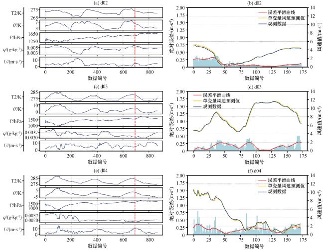
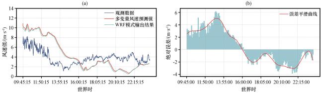
图13 WRF输出结果、 多变量风速预测结果与观测数据比较(a)为WRF输出结果、 多变量风速预测结果与观测数据曲线, (b)为WRF输出结果与观测数据间的误差及平滑曲线 Fig.13 Comparison of WRF output results, multivariate wind speed prediction results and observed data.(a) Curves of WRF output results, multivariate wind speed prediction results and observed data, (b) errors and smooth curves between WRF output results and observed data |