
1 引言
蒸散发(Evapotranspiration, ET)是大气水循环的关键环节, 也是陆地生态系统能量平衡的重要组成部分, ET的变化深刻影响着“地-气”系统的互馈过程。随着全球气候变暖(蒲春等, 2024), ET呈上升趋势。这一趋势对水资源的可用性和生态系统的稳定性提出了新的挑战, 对气候、 生态系统以及农业生产等方面有着重要影响(王周锋等, 2021), 特别对水资源匮乏的干旱地区, ET增加可能导致自然和人类用水矛盾更加突出(Zhao, 2020)。传统ET观测只能监测到站点周围一定范围ET, 无法实现对较大范围的监测, 并且由于自然及社会经济条件限制, 观测站点数量设置较少、 分布不均匀, 从站点尺度扩展到流域尺度乃至全球尺度时存在很大的不确定性 (刘宏鑫等, 2023, 王远征等, 2023)。
近年来, 随着遥感技术的进步, 基于各种估算模型的遥感ET产品实现了从流域乃至全球尺度的长时间动态监测(梁顺林等, 2020)。目前, 常见的遥感ET产品有SSEBop、 GLEAM、 MOD16、 PML_ V2、 GLASS和ETMonitor等, 这些ET产品各有特点和局限性。如SSEBop产品基于能量平衡模型生成(Senay et al, 2007), 该方法假设蒸散发速率与潜在蒸散发速率相等, 大大简化了计算过程, 适用于全球尺度ET估算, 其驱动数据主要为遥感数据和气象数据, 适合数据获取困难的地区。然而, 模型简化也导致估算精度有限, 特别是在复杂地区。GLEAM产品结合多种遥感数据和地面观测数据, 通过物理过程模拟提高了ET估算的准确性, 具有高时间分辨率的优点 (Miralles et al, 2011; 杨泽龙等, 2022)。然而, 其复杂的数据处理和模拟过程导致计算成本较高, 输入数据质量和覆盖范围直接影响ET计算的准确性, 特别是在高纬度地区和极端气候条件下表现不佳 (Qian et al, 2023)。MOD16产品是Mu et al(2007, 2011)基于Penman-Monteith模型改进算法提出的, 其主要驱动数据来自MODIS卫星数据, 通过叶面积指数(LAI)、 植被光合有效辐射吸收比(FPAR)等生成, 提供了高时空分辨率的全球ET产品。然而, ET的精度依赖于输入数据的质量, 且在地下水蒸散发显著地区存在低估情况(Yang et al, 2015)。PML_V2产品结合Penman-Monteith模型和Leuning模型, 利用多源遥感数据, 改进植被参数化方法, 提高了ET估算的准确性(Zhang et al, 2019)。然而, 其在高山、 极地和城市区域的表现不如在平坦地区(魏涛和王云权, 2023)。GLASS产品结合多种卫星数据和模型算法(蔡俊飞等, 2022), 提供了高时空分辨率的ET产品, 但其简化了植物水分传输物理过程, 显著降低了复杂地形和气候条件下ET的估算精度。ETMonitor产品通过校正不同地理区域和气候条件, 提高了ET估算的可靠性和准确性(Zheng et al, 2022; 郑超磊等, 2023)。然而, 其对遥感数据和地面观测数据质量要求较高, 且参数校正和优化增加了模型复杂性和工作量。这些遥感ET产品优缺点各异, 亟须对这些ET产品在由复杂地形、 气候和生态系统组成的流域内的表现开展评价。
黑河流域是中国第二大内陆河流域, 地处西北干旱半干旱区, 远离海洋、 气候干燥、 降水稀少、 蒸发强烈 (董世玉等, 2023)。流域上游以山地森林、 高寒草甸为主, 中游分布有大面积的农田绿洲和戈壁沙漠(窦寒梅等, 2024), 下游的额济纳绿洲是我国重要的天然生态屏障。因此准确量化蒸散发分布与变化对于区域生态建设和社会经济可持续发展至关重要。2007 -2009年, 在中国科学院西部行动计划二期项目“黑河流域遥感-地面观测同步试验与综合模拟平台建设”的支持下, 开展了“黑河综合遥感联合试验” (李新等, 2012)。“黑河综合遥感联合试验”获取了一套多尺度的航空-卫星遥感和地面同步观测数据集, 在蒸散发观测与遥感估算等方面取得了丰硕的成果。2010年, “黑河流域生态-水文过程集成研究”重大研究计划(简称“黑河计划”)启动, 建成了“黑河流域生态-水文过程综合遥感观测联合试验”(Xu et al, 2020)。2017年, 在前述基础上, 中国科学院西北生态环境资源研究院与北京师范大学共建的“黑河流域地表过程综合观测网”, 目前已发布11个站点的地表水热碳通量、 水文气象要素和植被参数等的多年连续数据集。根据已有的观测站点, Cui et al(2021)利用阿柔、 观滩、 盈科及大满等站点ET数据, 对双源能量平衡模型和深度神经网络模型的耦合进行了验证和评估, 结果显示该模型具有较高的准确度。Ding et al(2024)选择了流域内大沙龙、 大满、 四道桥等上中下游3个站点的数据, 对其水碳通量动态以及耦合模式进行研究, 结果显示大满农田生态系统的ET主要受气温和净辐射的控制, 而大沙龙和四道桥的ET主要受土壤温度和净辐射的调控, 表明这些生态系统存在能量限制。
总的来看, 在黑河流域开展的观测实验以及相关学者的研究多以站点尺度为主, 数据覆盖范围小, 缺乏对整个流域不同下垫面的综合考虑, 较少从流域尺度上来开展研究工作。因此, 本文通过收集并整理黑河流域不同下垫面基于涡度协方差技术的15个站点通量数据, 通过缺失值插补等得到不同下垫面站点多年蒸散发数据, 之后提取站点所在像元的ET产品年值, 评估了遥感ET产品的精度及其在黑河流域的适用性, 以期为干旱区流域ET模型选取提供科学依据。
2 研究区概况
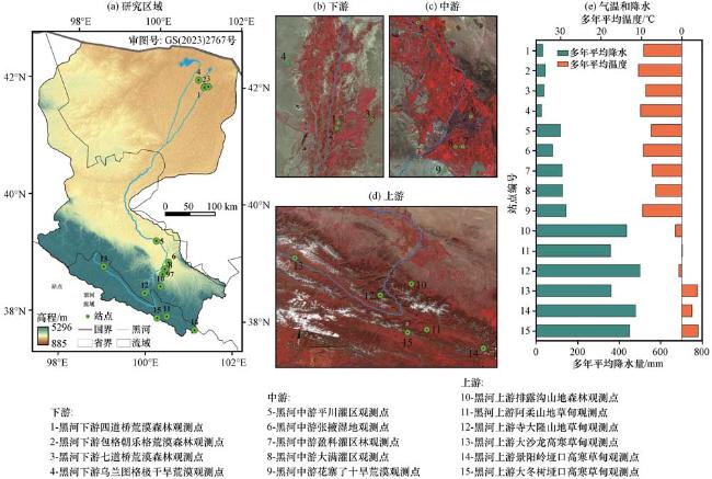
黑河流域是我国第二大内陆河流域, 主要包括祁连山地、 中部河西走廊和下游干旱荒漠绿洲, 大致介于98°E -102°E, 37°N -43°N, 流域面积约15.25 km2 [图1, 该图是基于中华人民共和国自然资源部地图技术审查中心标准地图服务系统下载的审图号为GS(2023)2767号的标准地图制作, 底图无修改]。黑河发源于青海省祁连山区, 流经河西走廊, 最终没入内蒙古额济纳旗的东、 西居延海。流域内气候、 地形地貌差异明显, 上游为高海拔山区, 气候较为湿冷, 多年平均降水量约为350 mm, 植被类型主要为高寒草甸、 灌丛和乔木林, 是黑河流域的产流区; 中游地区较为干旱, 多年降水量为60~160 mm, 但潜在ET在1000~2000 mm, 大部分面积被灌区覆盖, 是黑河流域主要耗水区; 下游为干旱荒漠区, 气候极端干旱, 多年平均降水量小于100 mm, 多年平均潜在ET大于2500 mm, 该区域内除河道两岸以及末端三角洲及居延海附近有少量植被分布外, 其他大部分地区被荒漠和戈壁覆盖(董世玉等, 2023; 鱼腾飞等, 2017)。
2 数据来源和方法介绍
2.1 蒸散发数据
本文选择以下6种ET产品在黑河流域地区进行验证和评估。(1) SSEBop 产品基于简化的地表能量平衡(SSEB)方法生成, 以 MODIS 数据和GLDAS 气象数据作为模型输入, 其最大的特点是使用了预定义的“热”和“冷”边界条件估算蒸散发。(2) GLEAM产品, 基于全球陆地蒸发阿姆斯特丹模型生成, 提供两个版本的蒸散发数据(v4.1a和v4.1b), 分别为1980年至现在, 2003年至现在, 该算法主要由潜在蒸散发模块、 降雨截留模块、 土壤水模块及胁迫模块构成, 其使用的驱动数据较少且多为遥感数据, 此外还考虑了高大植被、 低矮植被、 水体、 裸土等4种地表土地类型, 力求最大限度地恢复当前气候和环境变量卫星观测中包含的蒸发信息。(3)MOD16产品是通过Aqua和Terra卫星数据基于改进的Penman-Monteith模型生成的全球地表ET数据集, 其结合气象再分析数据和MODIS遥感数据进行计算, 提高了数据的物理意义和准确性, 该产品分别提供了蒸散发、 潜热通量、 潜在蒸散发和潜在潜热通量4个要素。(4)PML_V2产品由中国科学院地理科学与资源研究所张永强团队 (Zhang et al, 2019; Zhang et al, 2016b)基于Penman-Monteith-Leuning模型计算得到, 包括总初级生产力, 植被蒸腾, 土壤蒸发, 冠层截流蒸发和水体、 冰雪蒸发5个要素。其结合了气孔导度理论, 并耦合了GPP过程使得其在ET模拟的准确性上相较于以往的模型有了显著提升。(5)GLASS 产品, 使用贝叶斯平均方法集合5种潜热通量算法(MODIS算法、 改进的PM、 PT-JPL、 MS-PT以及半经验彭曼算法), 生成的覆盖全球陆表空间连续的潜热通量遥感产品, 大大降低单一算法的不确定性, 保证了产品的精度和质量。(6)ETMonitor产品基于S-W(Shuttleworth-Wallace)模型和优化过的RS-G(Remote Sensing-Gash)降雨截留模型生成, 利用FLUXNET等地面观测数据进行直接验证, 估算结果与地面实测数据一致性较好。以上6种蒸散发产品的主要特征信息见表1。
表1 蒸散发产品信息Table 1 Evapotranspiration product information |
| 产品 | 时间分辨率 | 空间分辨率 | 时间跨度 | 空间范围 | 数据来源 |
|---|---|---|---|---|---|
| SSEBop | 10天 | 1000 m | 2013 -2023年 | 全球 | https: //earlywarning.usgs.gov/ |
| GLEAM | 年/月 | 0.25° | 1980 -2023年 | 全球 | https: //www.gleam.eu/ |
| MOD16 | 8天 | 500 m | 2000 -2023年 | 全球 | https: //developers.google.com/ |
| PML_V2 | 8天 | 500 m | 2002 -2020年 | 全球 | https: //poles.tpdc.ac.cn/ |
| GLASS | 8天 | 0.05° | 2001 -2018年 | 全球 | http: //www.geodata.cn/ |
| ETMonitor | 月 | 1000 m | 2000 -2019年 | 全球 | https: //poles.tpdc.ac.cn/ |
2.2 涡动协方差通量数据
本文在研究区内共收集到15个地面观测站的涡度协方差通量数据, 其位置分布和简要信息分别见图1和表2。数据来源于国家青藏高原科学数据中心(http: //data.tpdc.ac.cn/)以及相关文献(Li et al, 2009; Liu et al, 2018; Yu et al, 2019; 高云飞, 2020; 吉喜斌等, 2023), 另外排露沟观测点的数据来自个人交流。由于观测数据的连续性以及可靠性, 需要对数据进行筛选, 之后使用R语言中的missForest包对缺失值进行插补, 最后得到完整的潜热通量数据。此外, 由于某些站点的数据起始年份只有少则几天、 多则不超3个月的有效数据, 为了更好地从年尺度上获取数据进行后续分析, 本文中对所使用数据集起始第一年的不完整数据进行了剔除。
表2 涡度通量观测站及数据信息Table 2 Eddy flux observatories and data information |
| 序号 | 行政区 | 观测点位置 | 经度 /°E | 纬度 /°N | 高程 /m | 年均降雨 /mm | 年均气温 /℃ | 生态系统类型 | 植被群系 | 时间 | 数据来源 |
|---|---|---|---|---|---|---|---|---|---|---|---|
| 1 | 内蒙古额济纳旗 | 四道桥 | 101.14 | 42.00 | 873 | 30 | 9.5 | 荒漠森林 | 柽柳纯林 | 2014 -2023年 | 刘绍民等, 2023 |
| 2 | 内蒙古额济纳旗 | 包格朝乐格 | 101.13 | 41.99 | 874 | 42.39 | 10.74 | 荒漠森林 | 胡杨+柽柳混交林 | 2014 -2023年 | 刘绍民等, 2023 |
| 3 | 内蒙古额济纳旗 | 七道桥 | 101.23 | 42.00 | 931 | 36.5 | 9 | 荒漠森林 | 胡杨纯林 | 2014 -2016年 | Yu et al, 2019 |
| 4 | 内蒙古额济纳旗 | 乌兰图格 | 100.99 | 42.11 | 1054 | 24.5 | 10.22 | 极干旱荒漠 | 红砂 | 2016 -2023年 | 刘绍民等, 2023 |
| 5 | 甘肃张掖 | 平川灌区 | 100.14 | 39.33 | 1381 | 117 | 7.6 | 农田 | 玉米 | 2012 -2015年 | 吉喜斌等, 2023 |
| 6 | 甘肃张掖 | 张掖湿地 | 100.45 | 38.98 | 1460 | 77.91 | 9.6 | 沼泽湿地 | 芦苇等 | 2013 -2022年 | 刘绍民等, 2023 |
| 7 | 甘肃张掖 | 盈科灌区 | 100.41 | 38.86 | 1519 | 124 | 7.4 | 农田 | 玉米 | 2008 -2011年 | 刘强等, 2015 |
| 8 | 甘肃张掖 | 大满灌区 | 100.37 | 38.86 | 1556 | 126.52 | 6.47 | 农田 | 玉米 | 2013 -2023年 | 刘绍民等, 2023 |
| 9 | 甘肃张掖 | 花寨子 | 100.32 | 38.77 | 1731 | 142.22 | 9.69 | 干旱荒漠 | 盐爪爪 | 2015 -2023年 | 刘绍民等, 2023 |
| 10 | 甘肃张掖 | 排露沟 | 100.29 | 38.55 | 2762 | 435.5 | 1.6 | 山地森林 | 青海云杉 | 2018 -2020年 | 郝玉莲, 2024 |
| 11 | 青海祁连县 | 阿柔 | 100.46 | 38.05 | 3033 | 357.57 | -0.12 | 山地草甸 | 垂穗披碱草+短颖鹅观草 | 2013 -2023年 | 刘绍民等, 2023 |
| 12 | 甘肃肃南县 | 寺大隆 | 99.93 | 38.43 | 3146 | 542.4 | 0.2 | 山地草甸 | 苔草+垂穗披碱草 | 2014 -2018年 | 高云飞, 2020 |
| 13 | 青海祁连县 | 大沙龙 | 98.94 | 38.84 | 3739 | 360.48 | -3.89 | 高寒草甸 | 西藏蒿草+喜马拉雅蒿草+矮生蒿草 | 2014 -2023年 | 刘绍民等, 2023 |
| 14 | 青海祁连县 | 景阳岭垭口 | 101.12 | 37.84 | 3750 | 478.5 | -2.52 | 高寒草甸 | 唐古拉红景天+青藏薹草+矮生蒿草 | 2018~2023年 | 刘绍民等, 2023 |
| 15 | 青海祁连县 | 大冬树垭口 | 100.24 | 38.01 | 4148 | 450.5 | -4.03 | 高寒草甸 | 红景天+青藏薹草 | 2016~2023年 | 刘绍民等, 2023 |
2.3 数据处理
下载获得的潜热通量数据经过质量控制以及数据清洗后, 各站点的半小时尺度的潜热通量数据存在不同程度的缺失情况, 本文采用随机森林(Random Forest)算法对缺失值进行插补以构建完整的数据集。本研究使用R语言的missForest包插补缺失数据, 该方法通过多次迭代的方式数据集中的缺失值, 该方法的优点是不需要对数据进行特定的分布假设, 这使得它适用于各种类型的数据, 包括连续型变量和分类变量。此外, 通过多次迭代插补的方法, 可以提供缺失值的不确定性估计, 尤其是在处理大量缺失值时仍能保持较高的准确性。
2.4 研究方法
2.4.1 蒸散发计算
待数据插补后, 使用式(1) 将30 min的潜热通量换算成ET (韩聪等, 2023):
式中: LE为潜热通量(单位: W·m-2); λ为水的汽化潜热值(取常数, 为2.45 kJ·g-1), 为水的密度(取常数, 为1 g·cm-3)。之后, 将每天30 min数据求和得到日蒸散发量(mm·day-1)。
2.4.2 评价指标
评价遥感蒸散发产品的常用指标有:
均方根误差(Root Mean Square Error, RMSE)(黄武斌等, 2024):
式中: 是观测值; 是模型估算值; N是样本数。RMSE用于衡量模型估算值与观测值之间的平均误差。
平均绝对误差(Mean Absolute Error, MAE):
MAE反映了估算值与观测值之间的平均绝对差异。
偏差(Bias):
偏差用于评估估算值是否系统性地高估或低估观测值, 如果Bias为正, 表示预测值总体偏高; 如果为负, 则表示预测值总体偏低。
决定系数(Coefficient of Determination, R 2 ):
式中: R²用于衡量模型解释观测数据变异的能力, 值越接近1表示数据拟合效果越好。
3 结果与分析
3.1 站点蒸散发数据分析
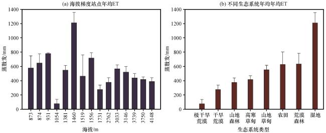
黑河流域15个涡度通量站点的蒸散发年内变化如图2所示, 以天然降水为主的荒漠生态系统(4和9)、 山地森林(10)、 山地草甸(11和12)和高寒草甸(13~15)的ET年际差异较大, 而其他以地表水和地下水为主的农田(5、 7和8)、 荒漠河岸森林(1~3)及湿地(6)年际变化较小。各通量站点海拔梯度多年蒸散发均值分布如图3(a)所示。整体上来看, 蒸散发多年均值整体呈增加趋势; 蒸散发值最高的是中游区域的张掖湿地站。多年均值为1210.72 mm, 最低的是下游区域的乌兰图格极干旱荒漠观测点, 多年均值为76.04 mm。而在中游区域的几个站点由于生态系统类型多样, 其不同站点之间蒸散发均值差异明显, 区域内蒸散发值最高与最低之间差值为934.54 mm, 而这一项差异在上游和下游区域则为188.87 mm和702.97 mm。各通量站点生态系统多年均值分布如图3(b)所示, 总的来看, 湿地生态系统的蒸散发值最高, 荒漠森林生态系统的蒸散发值次之, 农田生态系统与荒漠生态系统差异较小, 最低的是荒漠生态系统, 为181.99 mm, 而山地森林和高草甸生态系统的多年ET均值差异不大, 分别为376.97 mm和415.81 mm, 各生态系统多年蒸散发均值的大小顺序分别为湿地 > 荒漠森林 > 农田 > 山地草甸 > 高寒草甸 > 山地森林 > 干旱荒漠>极干旱荒漠。
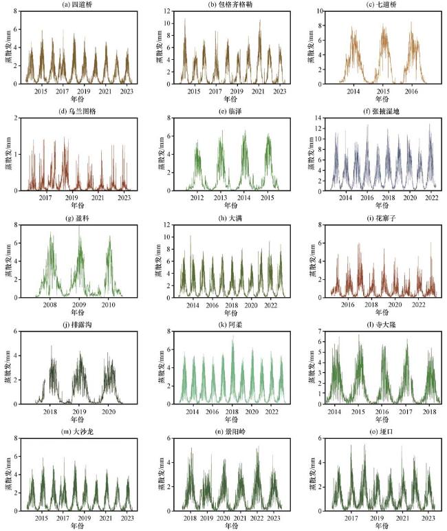
图2 黑河流域15个涡度通量站点日蒸散发的年变化编号见图1 Fig.2 Annual variation of daily evapotranspiration at 15 eddy flux stations in the Heihe River Basin.See Fig.1 for numbers |
3.2 遥感蒸散发产品时空分布
黑河流域6种遥感蒸散发产品多年均值空间分布如图4所示, 6种产品中流域多年均值最高的是MOD16产品, 为393.05 mm, 然后是GLASS蒸散发产品, 为309.64 mm, 而最小的是SSEBop产品, 为92.76 mm, PML_V2产品次之, 为128.49 mm。在流域内部尺度上, 呈现上游高, 中游次之, 下游低的态势。上游区域整体上蒸散发最高, 中游的蒸散发高值区位于绿洲和河道附近, 如张掖、 酒泉、 金塔及鼎新等绿洲区, 这些绿洲区也是整个流域的蒸散发最高值分布, 下游由于有大片的沙漠戈壁, 蒸散发高值区位于黑河末端的额济纳绿洲及居延海附近。而从6种产品的对比来看, ETMonitor、 GLASS、 SSEBop三种产品的流域多年蒸散发均值空间分布情况类似, 最高值区位于中游绿洲部分, MOD16产品由于其数据特性, 中下游存在大片空白区域, 且高值区多位于上游祁连山区部分。
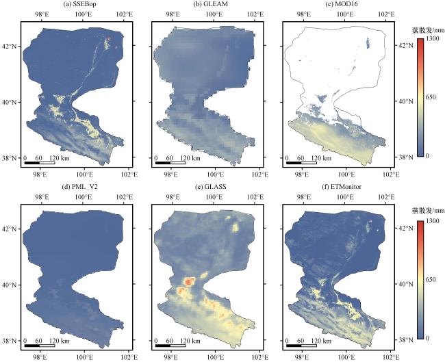
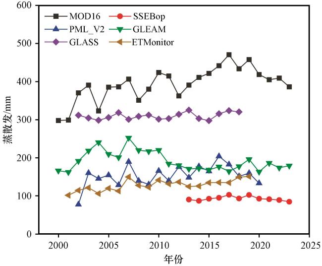
从黑河流域6种遥感蒸散发产品逐年均值时间变化(图5)可以看出, 整体上MOD16产品和GLASS产品多年的蒸散发值要高于其他四种产品, PML_V2产品和ETMonitor产品的相近, 最小的是SSEBop产品; 此外, 除MOD16、 GLASS和SSEBop产品以外的其他三种产品的逐年均值分布多处在100~250 mm之间。而从变化趋势来看, MOD16、 PML_V2、 ETMonitor和GLASS四种蒸散发产品多年蒸散发值呈现增加趋势, 增幅最大的是MOD16产品, 最小的是GLASS产品。而SSEBop产品和GLEAM产品则呈现出小幅的下降趋势
3.3 蒸散发产品整体精度评价
各站点蒸散发年值与各产品对应像元蒸散发值的拟合结果以及各评价指标见图6和表3所示, 可以看出, 从R²来看, 拟合效果较好的产品为SSEBop, 其次为ETMonitor和PML_V2, 而其余的三种产品的表现较差。6种产品中RMSE最小的是SSEBop产品, 为251.99 mm·a-1, 其次为ETMonitor产品的275.47 mm·a-1和GLASS产品的296.51 mm·a-1, RMSE最大的是GLEAM产品的442.31 mm·a-1, RMSE最大与最小的差值为190.32 mm·a-1。而就各个产品的Bias来看, 最小的是GLASS产品, 为-22.57 mm, 最大的是GLEAM产品, 为-317.49 mm, 差值在294.92 mm。各产品MAE从小到大的顺序为ETMonitor > SSEBop > GLASS > PML_V2 > MOD16 > GLEAM, MAE最大的ETMonitor与最小的GLEAM之间差距在142.76 mm。
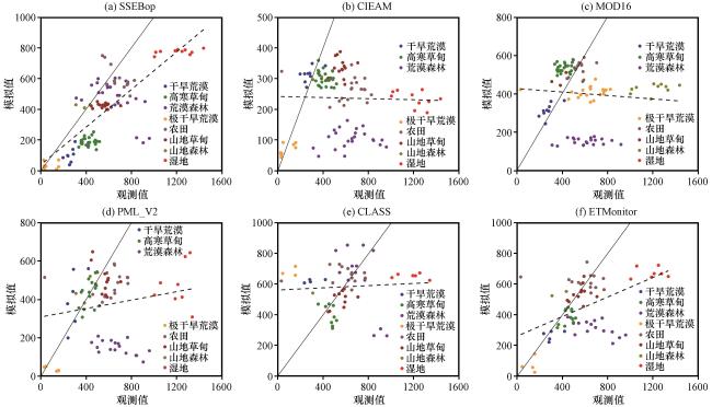
图6 地面站点与蒸散发产品拟合结果Fig.6 Fitting results of ground station and evapotranspiration product |
表3 蒸散发产品各指标Table 3 Indicators of evapotranspiration products |
| 产品 | 拟合方程 | 显著性 | RMSE/(mm·a-1) | Bias | MAE/(mm·a-1) | R² |
|---|---|---|---|---|---|---|
| SSEBop | y=0.612x+38.438 | P<0.01 | 251.99 | -178.42 | 200.65 | 0.63 |
| GLEAM | y=-0.009x+241.65 | p>0.05 | 442.31 | -317.49 | 332.79 | 0.0007 |
| MOD16 | y=-0.045x+427.80 | p>0.05 | 360.47 | -180.33 | 263.15 | 0.0068 |
| PML_V2 | y=0.11x+309.15 | p>0.05 | 363.99 | -204.97 | 259.72 | 0.033 |
| GLASS | y=0.036x+562.36 | p>0.05 | 296.51 | -22.57 | 212.09 | 0.004 |
| ETMonitor | y=0.318x+262.81 | P<0.01 | 275.47 | -140.37 | 190.03 | 0.26 |
4 讨论
对于各ET产品在不同生态系统的表现, 研究发现, 与地面通量观测站点数据相比, 各个遥感ET产品有着不同的表现。总体来看, SSEBop产品、 ETMonitor和GLASS产品在某些指标上表现较好, SSEBop产品的R²最优, GLASS产品的偏差最小, ETMonitor产品在除湿地、 荒漠森林之外的生态系统类型中表现最优。MOD16产品存在低值时高估、 高值时低估的现象, 尤其是在草甸类和农田类站点表现最为明显。GLEAM产品在湿润地区的表现较差, 低估现象尤为严重, 而在干旱地区的模拟效果相对较好。GLEAM产品低估蒸散发的严重程度可能与其模型对干湿度区域的响应能力有关。此外, GLASS产品在某些生态系统中表现出明显的高估现象, 尤其是在荒漠类站点, 高估现象尤为突出。ETMonitor产品在部分生态系统中的表现相对平衡, 但在某些生态系统中依然存在一定的偏差(图7, 表4)。总的来看, 各遥感产品在不同类型的生态系统中具有各自的优势和局限性。
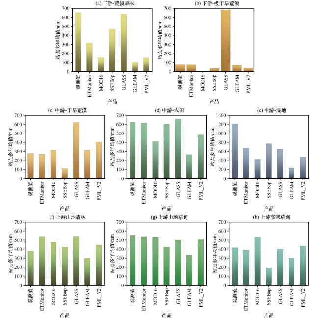
图7 不同生态系统各蒸散发产品对比(a)荒漠森林, (b)极干旱荒漠, (c)干旱荒漠, (d)农田, (e)湿地, (f)山地森林, (g)山地草甸, (h)高寒草甸 Fig.7 Comparison of evapotranspiration products in different ecosystems.(a) Desert forest, (b) extremely arid desert, (c) arid desert, (d) farmland, (e) wetland, (f) mountain forest, (g) mountain meadow, (h) alpine meadow |
表4 不同生态系统各蒸散发产品各指标Table 4 Different ecosystems have their own evapotranspiration products |
| 产品 | SSEBop | GLEAM | MOD16 | PML_V2 | GLASS | ETMonitor | |
|---|---|---|---|---|---|---|---|
| 农田 | 拟合方程 | y=-0.58x+1002.1 | y=0.08x+210.34 | y=0.09x+349.35 | y=0.27x+310.07 | y=-0.19x+780.02 | y=-0.12x+693.5 |
| R² | R²=0.5004 | R²=0.0514 | R²=0.1013 | R²=0.177 | R²=0.1434 | R²=0.0574 | |
| 显著性 | <0.01 | >0.05 | >0.05 | >0.05 | >0.05 | >0.05 | |
| 湿地 | 拟合方程 | y=0.06x+707.98 | y=-0.08x+331.85 | y=0.07x+346.7 | y=0.16x+284.3 | y=-0.03x+692.69 | y=0.01x+664.86 |
| R² | R²=0.2438 | R²=0.2015 | R²=0.1559 | R²=0.0273 | R²=0.0605 | R²=0.0006 | |
| 显著性 | >0.05 | >0.05 | >0.05 | >0.05 | >0.05 | >0.05 | |
| 干旱荒漠 | 拟合方程 | y=0.57x-47.08 | y=0.21x+255.69 | y=0.42x+196.35 | y=3.88x+330.95 | y=0.10x+591.85 | y=0.19x+210.51 |
| R² | R²=0.4703 | R²=0.3086 | R²=0.5109 | R²=0.0017 | R²=0.4851 | R²=0.1637 | |
| 显著性 | <0.05 | >0.05 | <0.05 | >0.05 | >0.05 | >0.05 | |
| 极干旱荒漠 | 拟合方程 | y=0.002x+33.46 | y=0.21x+52.57 | 无数据 | y=-0.18x+55.65 | y=0.16x+663.11 | y=0.17x+52.93 |
| R² | R²=3E-05 | R²=0.4758 | R²=0.9033 | R²=0.1082 | R²=0.0335 | ||
| 显著性 | >0.05 | 0.05 | 0.01 | >0.05 | >0.05 | ||
| 荒漠森林 | 拟合方程 | y=-0.34x+680.73 | y=0.05x+74.57 | y=0.01x+145.88 | y=-0.16x+254.74 | y=-0.92x+1272 | y=-0.21x+454.11 |
| R² | R²=0.1859 | R²=0.0507 | R²=0.0074 | R²=0.2657 | R²=0.1818 | R²=0.2535 | |
| 显著性 | <0.05 | >0.05 | >0.05 | <0.05 | >0.05 | 0.05 | |
| 山地森林 | 拟合方程 | y=-0.02x+430.3 | y=0.02x+293.77 | y=0.32x+351.99 | y=0.60x+219.58 | 数据≤2 | 数据≤2 |
| R² | R²=0.0135 | R²=0.0435 | R²=0.3551 | R²=0.2903 | |||
| 显著性 | >0.05 | >0.05 | >0.05 | >0.05 | |||
| 高寒草甸 | 拟合方程 | y=0.03x+177.71 | y=-0.10x+341.56 | y=0.07x+505.3 | y=0.53x+202.25 | y=-0.79x+767.46 | y=0.37x+220.07 |
| R² | R²=0.0033 | R²=0.0524 | R²=0.0318 | R²=0.1804 | R²=0.3541 | R²=0.163 | |
| 显著性 | >0.05 | >0.05 | >0.05 | >0.05 | >0.05 | >0.05 | |
| 山地草甸 | 拟合方程 | y=-0.01x+427.12 | y=0.07x+298.23 | y=0.19x+429.36 | y=-0.62x+852.3 | y=0.35x+306.17 | y=0.23x+411.66 |
| R² | R²=0.0012 | R²=0.0173 | R²=0.0883 | R²=0.361 | R²=0.2457 | R²=0.0909 | |
| 显著性 | >0.05 | >0.05 | >0.05 | <0.05 | >0.05 | >0.05 |
就黑河流域不同生态系统而言, 各产品的表现存在明显差异(图7, 表4)。首先, 下游的干旱区主要包括极干旱荒漠、 荒漠森林等生态系统。对于荒漠生态系统, GLASS产品存在严重的高估现象, 高估约465.19 mm; MOD16产品也有一定程度的高估, 主要原因是其使用的P-M公式在干旱荒漠地区误差较大, 将这些地区的蒸散发假设为零, 如图3(e)所示, 黑河流域下游地区存在大片空白区域, 实际上这些地区的蒸散发值并非为零, 这使得MOD16产品无法准确反映干旱荒漠或植被稀少地区的蒸散发特征(熊育久等, 2021)。此外, SSEBop产品在荒漠地区则低估了蒸散发, 其他三种产品在荒漠地区表现良好。同时, 不同站点之间也存在差异, 例如下游乌兰图格站点的年均ET较中游的花寨子站点低200 mm左右, 可能是由于下游戈壁荒漠面积较大, 而中游区域分布有河流和绿洲, 年降水量也相对较高。对于荒漠森林生态系统, 除GLASS产品外, 其他5种产品均呈现不同程度的低估, 低估最小的是SSEBop产品, 约为184.10 mm, ETMonitor次之, 而GLEAM产品低估最严重, 达到了约547.43 mm。同为森林类型, 荒漠森林的ET高于山地森林, 可能是因为二者处于不同的水热组合条件, 山地森林位于上游高海拔地区, 降水多但气温低, 而下游荒漠森林则降水较少, 但气温较高, 空气饱和亏缺严重。
黑河中游主要是以农田、 湿地以及外围的荒漠生态系统为主。对于农田生态系统, MOD16、 GLEAM和PML_V2产品均存在低估现象, 但低估幅度较小, 差异最大的是GLEAM产品, 低估约362.18 mm, 其余产品的表现优异, 差异仅在11~31 mm之间。对于蒸散发最大的湿地生态系统, 所选取的6种蒸散发产品均有低估现象, 其中GLEAM产品低估最为严重, 约为976.87 mm, ETMonitor、 SSEBop、 GLASS产品的表现较为相似。整体来看, 各类遥感产品严重低估了湿地生态系统ET, 一方面可能是由于湿地相对于其他生态系统, 具有更为复杂的水文动态和多样的植被类型, 而这并未能被遥感产品的简化模型充分反映, 各产品对湿地ET的低估(杨泽龙等, 2022)。另一方面可能是因为干旱区地下水埋深较浅、 土壤含水量较高, 湿地本身ET较高(Zhang et al, 2016a), 如本文中的湿地站点所在地下水埋深在1 m以内, 这为蒸散发提供了充足的水分来源。
黑河流域上游主要是山地森林、 山地及高寒草甸等生态系统。对于山地森林和山地草甸, GLEAM产品也有一定程度的低估, 分别为76.75 mm和219.22 mm, 其他5种产品在山地森林中均呈现不同程度的高估, 其中GLASS产品高估最多, 约为165.33 mm; 在山地草甸中, 除SSEBop和GLEAM产品外, 其他4种产品表现良好, 差异在13~53 mm之间。ETMonitor产品在山地森林中存在高估, 而在山地草甸中表现良好, MOD16产品的表现则恰好相反。总体来看, MOD16产品表现出低值高估、 高值低估的现象, 尤其是在草甸和农田站点(刘宏鑫等, 2023)。对于山地草甸, SSEBop产品也有明显的低估, 约为130.97 mm, 而其他产品表现优异。值得注意的是, 对于高寒草甸, MOD16是唯一高估的产品, 高估约为119.41 mm; SSEBop产品低估最明显, 约为226.52 mm, GLEAM产品次之, 其他3种产品均表现良好。各生态系统年均ET显示, 山地森林与高寒草甸的ET差异较小, 可能是由于两者海拔高度和温湿度状况相似。
对于同一区域的各个遥感蒸散发产品来说, 不同的空间分辨率不会对该区域的蒸散发均值产生影响, 但是各个产品在模拟过程中所使用的驱动数据由于来源不同, 制作不同, 因此会具有不同的空间分辨率, 这会对最终的蒸散发模拟产生一定程度的影响。荒漠森林系统的差异可能与分辨率有关, GLEAM产品的分辨率为0.25°, 难以准确反映黑河下游末端的荒漠森林系统, 而在农田地区, 较低的空间分辨率同样无法准确反映地表复杂区域的蒸散发差异(熊育久等, 2021)。此外, GLASS产品在荒漠类站点严重高估, 而在荒漠森林站点低估, 可能是因为荒漠地区的裸露土壤或低矮植被导致模型未能准确捕捉蒸散发过程。裸露土壤在高温下可能大量蒸发水分, 而GLASS模型将这种蒸发计入蒸散发总量中。同时, GLASS模型依赖卫星观测数据和参数化方案, 未能充分考虑地下水对荒
漠森林蒸散发的贡献, 导致模拟结果偏差。纵观黑河流域, 各生态系统内部的各产品表现参差不齐, 在山地森林、 山地草甸、 高寒草甸以及农田类的站点差异较小, 而荒漠、 荒漠森林以及湿地类站点的差异明显。在站点缺失值插补以及蒸散发产品预处理过程中的误差可能会导致本文的结果与前人研究有出入, 此外数据获取以及站点布设位置的原因会导致本文选取的通量站点数量以及下垫面类型依然有一些欠缺之处, 例如本文中湿地类和山地森林类的站点只有一个, 其蒸散发产品表现的结论是否适用于其他的同类型条件的站点有待后续研究补充验证。另外, 本文中选取站点的观测数据涉及年时间尺度还相对不够长, 无法反映更长时间尺度上的蒸散发变化以及各蒸散发产品表现, 后续需要拓宽数据获取渠道以及拉长时间尺度, 以期获得更具说服力的结果。
5 结论
为了评价全球尺度蒸散发产品在黑河流域的适用性, 本文收集了黑河流域不同下垫面的15个站点、 113个站点年的潜热通量数据, 通过采用随机森林算法插补缺失值得到各站点多年的日蒸散发数据, 采用R 2、 RMSE、 MAE、 Bias等指标对蒸散发产品在黑河流域的表现进行比较, 得到以下主要结论:
(1) 站点尺度上, 湿地生态系统ET最大, 约为1210 mm, 荒漠生态系统ET最小, 约为180 mm, 各生态系统ET从大到小依次为: 湿地、 荒漠森林、 农田、 山地草甸、 高寒草甸、 山地森林、干旱荒漠和极干旱荒漠。从下游至上游沿海拔梯度, 呈先增加后减少的趋势。
(2) 总体而言, 6种ET产品在黑河流域的表现存在明显差异, SSEBop产品表现最好, 与各通量站点之间的R 2最大, 为0.63。其次是ETMonitor产品, R 2为0.26, 其他产品均表现较差。值得注意的是, 6种产品的Bias最小的是GLASS产品, 为-22.57 mm, 最大的是GLEAM产品, 为-317.49 mm。
(3) 就不同的生态系统而言, 6种产品与观测值之间的差异也非常明显。农田、 山地森林、 山地草甸和高寒草甸与遥感ET产品的差异相对较小, 其中MOD16产品明显高估了高寒草甸ET, 而低估了农田ET。荒漠和荒漠森林与遥感ET产品的差异相对较大, 其中GLASS 产品对荒漠ET明显高估而在荒漠森林中表现优异。6种产品均低估了湿地ET。