
1 引言
2 资料来源与方法介绍
2.1 资料来源
2.2 方法介绍
2.2.1 锋生函数
2.2.2 湿位涡
3 降水概况和环流演变特征
3.1 降水实况
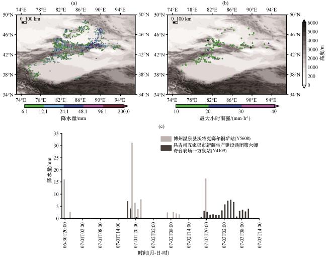
图1 2024年6月30日20:00至7月3日23:00降水等级实况(a, 彩色圆点, 单位: mm)、 最大雨强≥10 mm·h-1站点分布(b, 彩色圆点, 单位: mm·h-1)、 6月30日20:00至7月3日14:00暴雨代表站逐小时降水量(c)灰色填充区为地形高度(单位: m); ●代表博州温泉县沃特克赛尔铜矿站(Y5608), ▲代表昌吉州五家渠市新疆生产建设兵团第六师奇台农场一万泉站(Y4109)Fig.1 Real situation of precipitation levels from 20:00 on June 30 to 23:00 on July 3, 2024 (a, colored dots, unit: mm), distribution of stations with maximum rain intensity greater than or equal to 10 mm·h-1 (b, colored dots, unit: mm·h-1), and hourly precipitation of representative stations of heavy rain from 20:00 on June 30 to 14:00 on July 3 (c).Gray shaded areas represent terrain height (unit: m); ● represents Wotkesaier Copper Mine Station in Wenquan County, Bozhou Prefecture (Y5608), ▲ represents Yiwanquan Stationof Qitai Farm, Sixth Division, Xinjiang Production and Construction Corps, Wujiaqu City, Changji Prefecture (Y4109) |
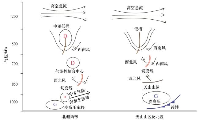
3.2 环流演变特征
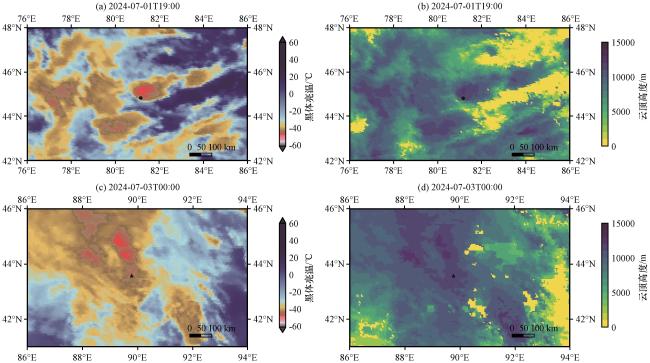
4 对流云团演变特征
5 不稳定机制
5.1 博州短时暴雨不稳定机制
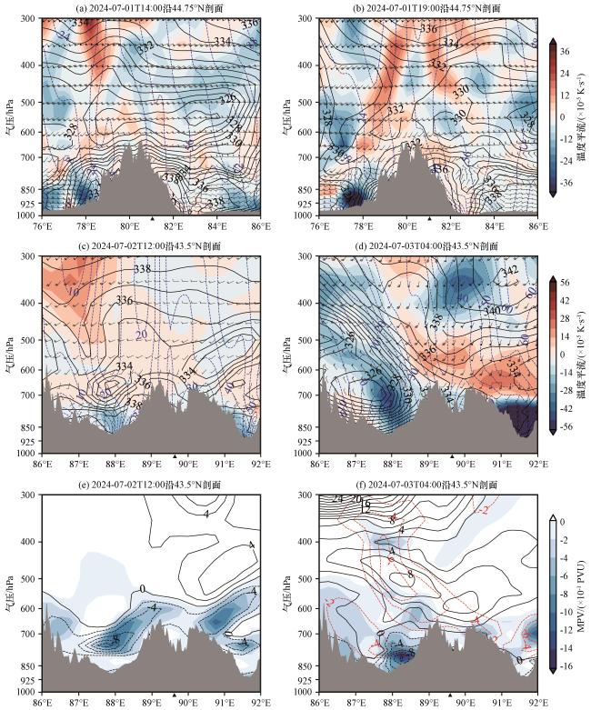
图4 2024年7月1日沿44.75°N 14:00(a)、 19:00(b)、 2日沿43.5°N 12:00(c)、 3日04:00(d)温度平流(彩色阴影, 单位: ×10-5 K·s-1)、 假相当位温(黑色等值线, 单位: K)、 风场(矢量, 单位: m·s-1)、 绝对地转角动量(蓝色等值线, 单位: m·s-1)和2024年7月2日12:00(e)、 3日04:00(f)沿43.5°N MPV(彩色阴影, 单位: ×10-1 PVU)、 MPV1(黑色等值线, 单位: ×10-1 PVU)、 MPV2(红色等值线, 单位: ×10-1 PVU)▲为暴雨中心代表站经度位置, 阴影为地形Fig.4 14:00 (a) and 19:00 (b) along 44.75°N on July 1 2024, 12:00 (c) on July 2 2024, and 04:00 (d) on July 3 2024 along 43.5°N temperature advection (colored shading, unit: ×10-5 K·s-1), false equivalent potential temperature (black contour, unit: K), wind field (vector, unit: m·s-1), absolute geoangular momentum (blue contour, unit: m·s-1) and 12:00 (e) on July 2 2024, 04:00 (f) MPV (colored shading, unit: ×10-1 PVU) along 43.5°N on July 3 2024, MPV1 (black contour, unit: ×10-1 PVU), MPV2 (red contour in ×10-1 PVU).▲ represents the longitude position of the representative station in the rainstorm center, The shaded areas indicate the terrain |
5.2 中天山暴雨不稳定机制
6 触发机制
6.1 博州短时暴雨触发机制
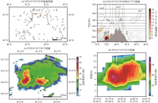
图5 2024年7月1日19:00地面风场(风羽, 单位: m·s-1)(a)、 18:00锋生函数(彩色阴影, 单位: ×10-9 K·m-1·s-1)、 垂直速度(等值线, 单位: Pa·s-1)、 流线[风矢量表示u和w合成风场(下同), w放大50倍, 单位: m·s-1]剖面图(b)、 18:23伊宁雷达组合反射率因子(彩色阴影, 单位: dBz)(c)、 反射率因子(彩色阴影, 单位: dBz)垂直剖面(d) 图(a)●代表Y5608, 图(b)▲代表暴雨中心代表站经度位置Fig.5 Surface wind field (barb, unit: m·s⁻¹) at 19:00 on July 1 2024 (a), cross-sectional diagram of frontogenesis function (color shading, unit: ×10⁻⁹ K·m⁻¹·s⁻¹), vertical velocity (contour line, unit: Pa·s⁻¹), and streamline [wind vector represents the combined wind field of u and w (the same below), with w amplified by 50 times, unit: m·s⁻¹)] at 18:00 (b), Yining radar composite reflectivity factor at 18:23 (colored shading, unit: dBz) (c), vertical section of reflectivity factor(colored shading, unit: dBz) (d).●represents Y5608 in (a).▲indicates the longitude position of the representative station in the rainstorm center in (b) |
6.2 中天山暴雨触发机制
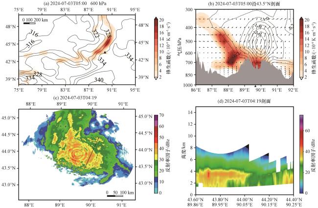
图6 2024年7月3日05:00 600 hPa锋生函数(彩色阴影, 单位: ×10-9 K·m-1·s-1)和假相当位温(等值线, 单位: K)(a)、 3日05:00锋生函数(彩色阴影, 单位: ×10-9 K·m-1·s-1)、 垂直速度(等值线, 单位: Pa·s-1)、 流线(风矢量, 单位: m·s-1)剖面图(b)、 3日04:19奇台雷达组合反射率因子(彩色阴影, 单位: dBz)(c)、 反射率因子(彩色阴影, 单位: dBz)垂直剖面(d)图(a) ▲代表Y4109, 图(b) ▲代表暴雨中心代表站经度位置Fig.6 The frontogenesis function (colored shading, unit: ×10-9 K·m-1·s-1) and pseudo-equivalent potential temperature (contour line, unit: K) at 600 hPa on July 3 2024, at 05:00(a), cross-sectional diagram of frontogenesis function (colored shading, unit: ×10⁻⁹ K·m⁻¹·s⁻¹), vertical velocity (contour lines, unit: Pa·s⁻¹), and streamlines (wind vectors, unit: m·s⁻¹) at 05:00 on the 3rd.(b), the composite reflectivity factor of Qitai radar at 04:19 on the 3rd (colored shading, unit: dBz) (c), and the vertical section of the reflectivity factor (colored shading, unit: dBz)(d).▲ represents Y4109 in (a).▲ indicates the longitude position of the representative station in the rainstorm center in (b) |