
1 引言
2 资料来源和方法介绍
3 过程覆冰概况
3.1 空间分布特征
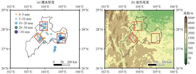
图1 2023年12月16-22日昭通观测覆冰厚度空间分布(a, 单位: mm), 昭通地区地形高度(b, 单位: m)三个红色方框分别表示3个覆冰厚度高值中心 Fig.1 Spatial distribution of the observed ice-coating thickness in Zhaotong from December 16 to 22 of 2023 (a, unit: mm), the topographic height of Zhaotong (b, unit: m).The three red boxes indicate the centers of three high-value areas of ice-coating thickness, respectively |
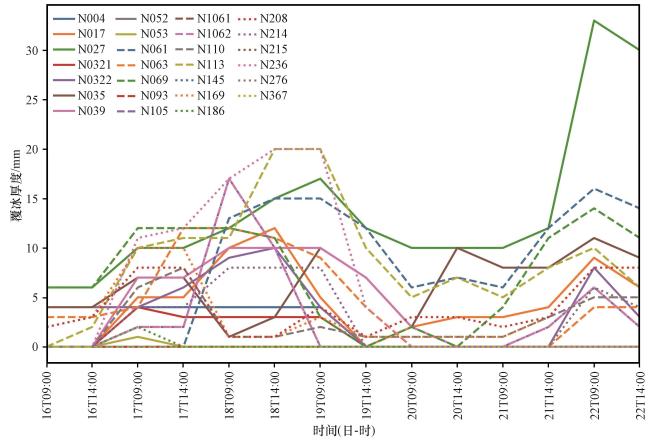
3.2 时间分布特征
4 覆冰类型及形成气象条件
4.1 地面气象要素特征
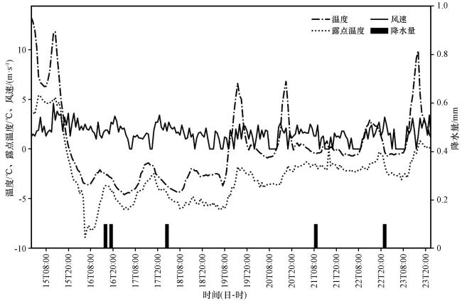
图3 2023年12月15日00:00至23日23:00镇雄站气温、 露点温度、 风速及降水量逐小时演变Fig.3 The temporal evolution of temperature, dew point temperature, wind speed and precipitation at Zhenxiong station from 00:00 on December 15th to 23:00 on December 23th, 2023 |
表1 镇雄站覆冰过程中部分时次地面气象观测要素Table 1 The surface meteorological observation elements at Zhenxiong station during the icing process |
| 观测要素 | 15日16:00 | 15日19:00 | 15日20:00 | 15日21:00 | 15日22:00 | 16日15:00 | 16日16:0 | 16日17:00 | 16日18:00 | 16日19:00 |
|---|---|---|---|---|---|---|---|---|---|---|
| 气温/℃ | 5.1 | 1.2 | 0.3 | -0.3 | -0.9 | -2.4 | -2.6 | -2.6 | -2.8 | -2.9 |
| 露点温度/℃ | 3.8 | -0.1 | -1 | -1.6 | -2.6 | -4 | -3.7 | -3.7 | -3.8 | -4.3 |
| 降水量/mm | / | / | / | / | / | / | 0.1 | / | / | 0.1 |
| 现在天气现象 | 雨夹雪 | 小雨 | 轻雾 | 小雪 | 雨夹雪 | 轻雾 | 轻雾 | 轻雾 | 小雪 | 轻雾 |
| 风向/(°) | 319 | 322 | 354 | 294 | 319 | 308 | 300 | 293 | 301 | 298 |
| 风速/(m·s-1) | 3.5 | 2.4 | 3.6 | 1.3 | 2.6 | 1.7 | 1.9 | 1.9 | 1.5 | 2.7 |
| 观测要素 | 18日00:00 | 18日01:00 | 18日02:00 | 18日03:00 | 18日04:00 | 21日08:00 | 21日09:00 | 21日10:00 | 21日11:00 | 21日12:00 |
| 气温/℃ | -3.5 | -3.7 | -3.9 | -4 | -4.1 | -0.4 | -0.5 | -0.4 | -0.4 | -0.3 |
| 露点温度/℃ | -4.2 | -4.4 | -4.9 | -5 | -5.2 | -1.7 | -1.5 | -2 | -1.8 | -1.6 |
| 降水量/mm | / | 0.1 | / | / | / | / | 0.1 | / | / | / |
| 现在天气现象 | 轻雾 | 轻雾 | 轻雾 | 轻雾 | 轻雾 | 雨夹雪 | 雨夹雪 | 霾 | 轻雾 | 轻雾 |
| 风向/(°) | 296 | 312 | 291 | 298 | 297 | 314 | 315 | 91 | / | 308 |
| 风速/(m·s-1) | 2.6 | 1.8 | 2.7 | 2.2 | 2 | 1.3 | 1.3 | 2.4 | / | 1.1 |
/代表无观测数据(/ represents no observation data) |
4.2 天气系统与覆冰类型
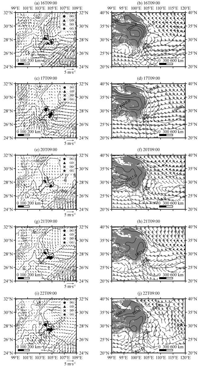
图4 2023年12月昭通覆冰过程中地面气温(等值线, 单位: ℃)、 风场(矢量, 单位: m·s-1)及覆冰类型(左); 海平面气压(等值线, 单位: hPa)及700 hPa风场(风羽, 单位: m·s-1)(右)右侧图中灰色阴影为地形高度(≥3000 m) Fig.4 Surface temperature (unit: ℃), surface wind (unit: m·s-1) and ice-coating types (left), sea level pressure (unit: hPa) and 700 hPa wind (unit: m·s-1) (right) during the icing process in Zhaotong in December 2023.The gray shaded areas in right figures drepresent the terrain elevation (≥3000 m) |
5 不同类型覆冰气象要素的垂直分布
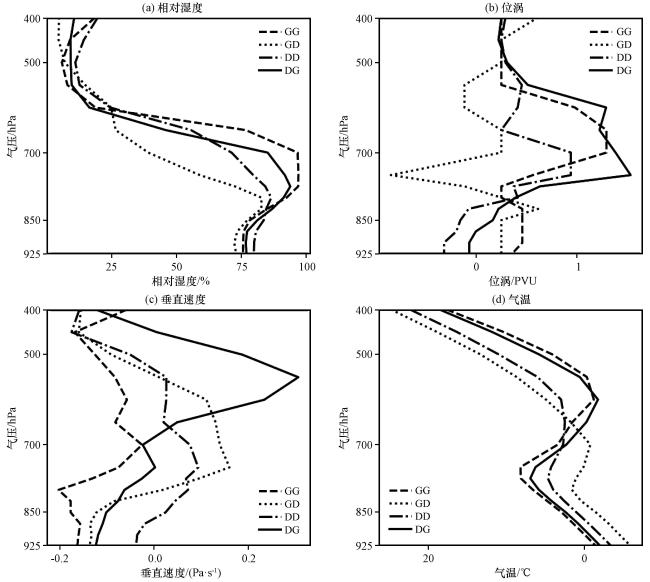
图5 不同覆冰类型合成气象要素垂直剖面图(a)相对湿度(单位: %), (b)位涡(单位: PVU, 1 PVU=1×10⁻⁶ K·m2·kg-1·s-1), (c)垂直速度(单位: Pa·s-1), (d)气温(单位: ℃) Fig.5 Vertical profiles of composite meteorological elements for different ice-coating types.(a) relative humidity (unit: %), (b) potential vorticity (unit: PVU, 1 PVU=1×10⁻⁶ K·m2·kg-1·s-1), (c) vertical velocity (unit: Pa·s-1) and (d) temperature (unit: ℃) |
6 不同类型覆冰要素空间剖面
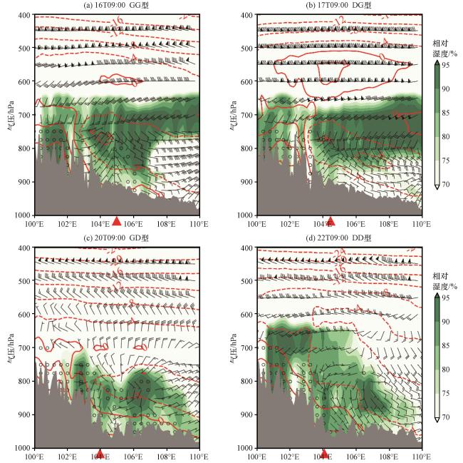
图6 2023年12月不同类型覆冰气温(等值线, 单位: ℃)、 相对湿度(绿色阴影, 单位: %)及风场(单位: m·s-1)的纬向垂直剖面图(a)16日09:00 GG型沿27.54°N剖面图, (b)17日09:00 DG型沿27.52°N剖面图, (c)20日09:00 GD型沿28.09°N剖面图, (d)22日09:00 DD型沿28.08°N剖面图灰色阴影为地形, 红色三角形为观测覆冰位置 Fig.6 Vertical cross sections of temperature (contours, unit: ℃), relative humidity (green shading, unit: %) and wind (unit: m·s-1) for different icing types at 27.54°N for GG at 09:00 on December 16, 2023 (a), at 27.52°N for DG at 09:00 on December 17, 2023 (b), at 28.09°N for GD at 09:00 on December 20, 2023 (c) and at 28.08°N for DD at 09:00 on December 22, 2023 (d).The grey shaded area represents the terrain and the red triangles indicate observed ice-coating locations |