
1 引言
2 数据来源与方法介绍
2.1 观测数据集
2.2 研究区域
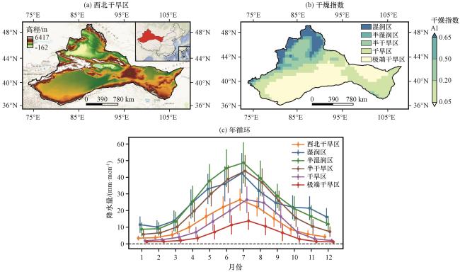
图1 1961 -2021年中国西北干旱区高程(a, 单位: m)、 基于干燥指数AI划分的干湿子区域(b)及其降水量月变化(c, 单位: mm·mon-1)(c)中圆点和短竖线分别表示月降水量的气候平均值和1倍标准差(单位: mm·mon-1) Fig.1 Elevation (a, unit: m) in the arid region of Northwest China (NWC), five sub-regions classified by the Aridity Index (AI) (b) and monthly evolution of precipitation (unit: mm·mon-1) over each sub-regions during 1961 -2021.In (c), dots and short vertical bars indicate climatology and one standard deviation for monthly precipitation (unit: mm·mon-1) |
2.3 降水均匀性表征
2.3.1 月尺度降水均匀性
2.3.2 日尺度降水均匀性
2.4 统计方法
3 结果分析
3.1 月尺度降水均匀性的长期变化特征
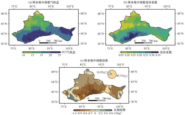
图2 1961 -2021年中国西北干旱区月尺度降水集中指数(PCI)气候态(a)、 变异系数(b)和长期趋势[c, 单位: (10a)-1]的空间分布(c)中黑色斜线表示通过p < 0.05的显著性检验, 饼图表示下降(黄色)和上升(浅绿色)趋势区域占西北干旱区面积的百分比(单位: %) Fig.2 Spatial distribution of the climatology (a), coefficient of variation (b), and long-term trend [c, unit: (10a)-1] of the monthly-scale Precipitation Concentration Index (PCI) in the arid region of Northwest China (NWC) during 1961 -2021.In (c), black slanted lines indicate areas passing the 0.05 significance test.The pie charts depict the percent area (unit: %) with decreasing (yellow) and increasing (light-green) trends in NWC |
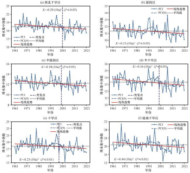
图3 1961 -2021年中国西北干旱区及5个干湿子区域月尺度降水集中指数(PCI)的时间变化序列(a)西北干旱区, (b)湿润区, (c)半湿润区, (d)半干旱区, (e)干旱区, (f)极端干旱区。浅蓝色实线和虚线分别为PCI的区域平均序列及其9年滑动平均序列, 红色实线和黑色虚线分别为线性趋势和平均值, 垂直蓝色虚线为突变点年份, K值为线性趋势斜率[单位: (10a)-1] Fig.3 Temporal changes of the monthly-scale Precipitation Concentration Index (PCI) area-averaged in the arid region of Northwest China (NWC) and its five dry-wet sub-regions during 1961-2021.(a) NWC, (b) humid, (c) semi-humid, (d) semi-arid, (e) arid, (f) hyper-arid.The light blue solid and dashed lines represent the regional mean PCI series and its 9-year moving average, respectively.The red solid lines and black dashed lines indicate the linear trend and the mean value, respectively, the vertical blue dashed lines mark the abrupt change year, and Kdenotes the slope of the linear trend [unit: (10a)-1] |
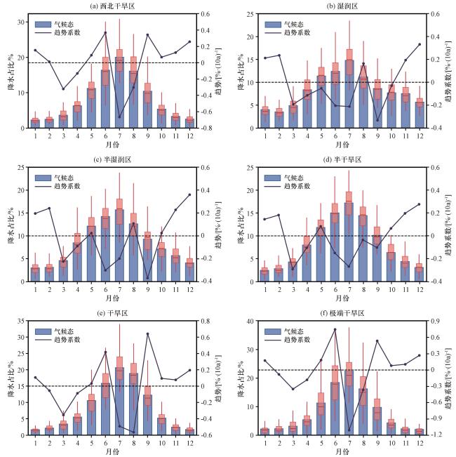
图4 1961 -2021年中国西北干旱区和5个干湿子区域逐月降水量占年降水量比例(MPAP)的气候平均值(单位: %)和长期趋势增率[单位: %·(10a)-1](a)西北干旱区, (b)湿润区, (c)半湿润区, (d)半干旱区, (e)干旱区, (f)极端干旱区。蓝色柱状表示MPAP的气候平均值(单位: %), 盒须图表示1961 -2021年各月MPAP的统计特征, 盒体表示第25百分位数至第75百分位数的范围, 红线为中位数, 蓝色实线表示MPAP的长期趋势系数[单位: %·(10a)-1] Fig.4 Climatology (unit: %) and long-term tendency [units: %·(10a)⁻¹] of the Monthly Percentage of Annual Precipitation (MPAP) in the arid region of Northwest China (NWC) and its five dry-wet sub-regions during 1961 -2021.(a) NWC, (b) Humid, (c) semi-humid, (d) semi-arid, (e) arid, (f) hyper-arid.Blue bars represent the climatological mean of MPAP (unit: %), and boxplots illustrate the statistics of MPAP with the interquartile range (25th to 75th percentiles) and the median value (red lines) during 1961 -2021.(b) The blue solid line indicates the long-term tendency [unit: %·(10a)-1] |
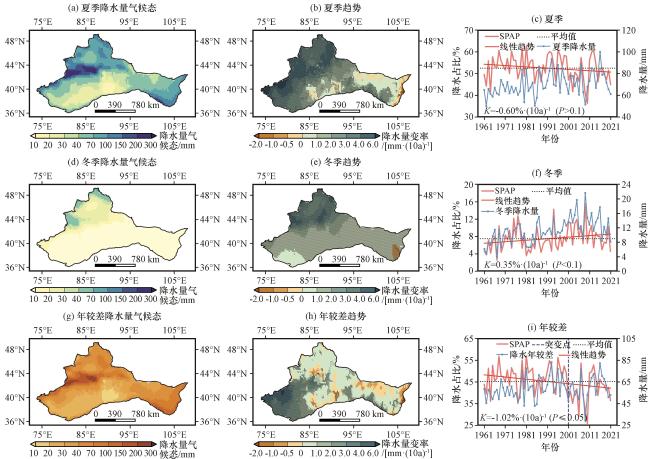
图5 1961 -2021年中国西北干旱区夏季(a~c)、 冬季(d~f)降水量及其年较差(g~i)的时空变化(a, d, g)气候态空间分布(单位: mm); (b, e, h)长期趋势空间分布[单位: mm·(10a)-1]; (c, f, i)季节降水量(单位: mm)及其占年降水量比例(SPAP, 单位: %)的时间变化序列 Fig.5 Temporal and spatial variation of summer (a~c) and winter (d~f) precipitation and their annual range (g~i) in the arid region of Northwest China (NWC) during 1961 -2021.(a, d, g) spatial distribution of the climatology (unit: mm); (b, e, h) spatial distribution of the long-term trends [unit: mm·(10a)-1]; (c, f, i) temporal variations of seasonal precipitation (unit: mm) and its proportion of annual precipitation (SPAP, unit: %) |
表1 1961 -2021年中国西北干旱区和5个干湿子区域四季降水变化的趋势系数及其相对变化率Table 1 The long-term tendency coefficient and relative change of seasonal precipitation in the arid region of Northwest China and its five dry-wet sub-regions during 1961 -2021 |
| 春季 | 夏季 | 秋季 | 冬季 | |||||
|---|---|---|---|---|---|---|---|---|
| 趋势系数/[mm·(10a)-1] | 相对变化率/[%·(61a)-1] | 趋势系数/[mm·(10a)-1] | 相对变化率/[%·(61a)-1] | 趋势系数/[mm·(10a)-1] | 相对变化率/[%·(61a)-1] | 趋势系数/[mm·(10a)-1] | 相对变化率/[%·(61a)-1] | |
| 西北干旱区 | 0.87 | 16.62 | 2.25** | 19.51 | 1.82** | 15.73 | 1.06 | 57.22 |
| 湿润区 | 1.25 | 10.75 | 3.10* | 17.15 | 2.06* | 18.5 | 3.11** | 50.27 |
| 半湿润区 | 1.53 | 12.23 | 3.10* | 14.20 | 2.18* | 20.08 | 2.94** | 60.56 |
| 半干旱区 | 1.47 | 14.9 | 3.00** | 15.36 | 2.40** | 28.31 | 1.98** | 61.55 |
| 干旱区 | 0.79 | 19.7 | 2.20* | 18.84 | 2.20** | 51.18 | 0.57** | 55.06 |
| 极端干旱区 | 0.54 | 26.34 | 1.75** | 29.97 | 1.24** | 69.49 | 0.40** | 63.6 |
*表示通过0.05显著性检验, **表示通过0.01显著性检验(* indicates significance at the 0.05 level, ** indicates significance at the 0.01 level) |
3.2 日尺度降水均匀性的长期变化特征
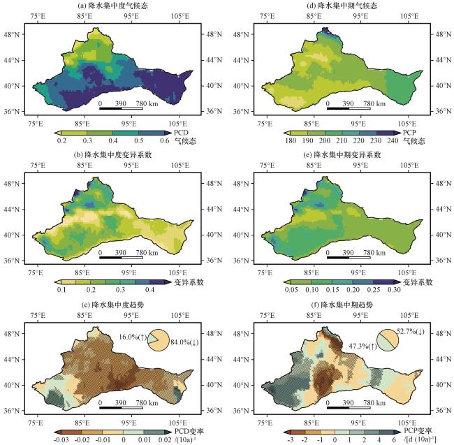
图6 1961 -2021年中国西北干旱区日尺度降水集中度(PCD)和降水集中期(PCP)气候态(a, d)、 变异系数(b, e)和长期趋势[c, 单位: (10a)-1; f, 单位: d·(10a)-1]的空间分布(c)和(f)中黑色斜线表示通过0.05显著性检验, 饼图表示下降(黄色)和上升(浅绿色)趋势区域占西北干旱区面积的百分比(单位: %) Fig.6 Spatial distribution of the climatology (a, d), coefficient of variation (b, e), and long-term trend [c, unit: (10a)⁻¹; f, unit: d·(10a)⁻¹] for the daily-scale Precipitation Concentration Degree (PCD) and Precipitation Concentration Period (PCP) in the arid Northwest China (NWC) during 1961 -2021.Black slanted lines in (c) and (f) indicate areas passing the 0.05 significance test, and the pie charts show the percent area (unit: %) with decreasing (yellow) and increasing (light green) trends in NWC |
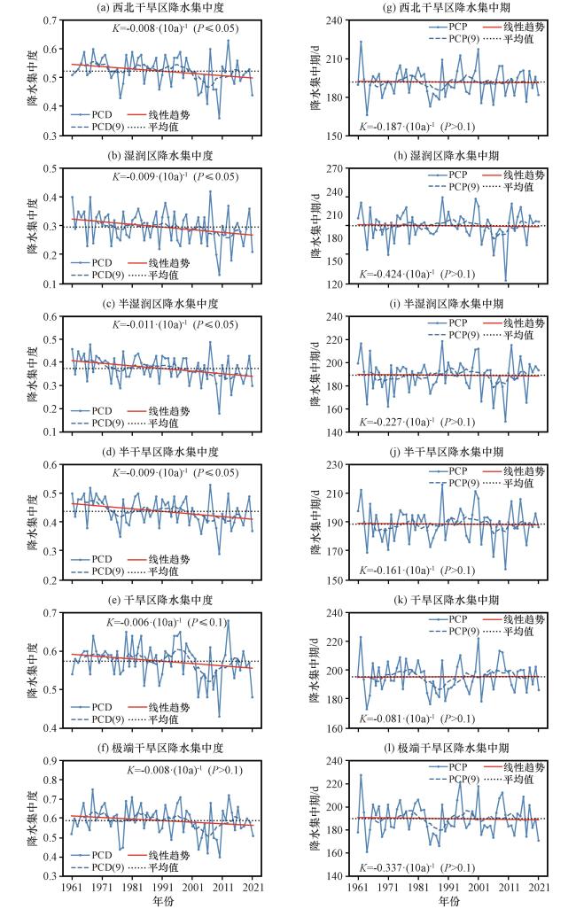
图7 1961 -2021年中国西北干旱区和5个干湿子区域日尺度降水集中度(PCD)和降水集中期(PCP)的时间变化序列(a, g)西北干旱区, (b, h)湿润区, (c, i)半湿润区, (d, j)半干旱区, (e, k)干旱区, (f, l)极端干旱区。蓝色实线和虚线分别表示PCD和PCP的年际变化及其9年滑动平均值, 红色实线和黑色虚线分别表示线性趋势和平均值, K为线性趋势的斜率[单位: (10a)-1] Fig.7 Temporal evolution of the Precipitation Concentration Degree (PCD) and Precipitation Concentration Period (PCP) at the daily scale in the arid Northwest China (NWC) and five dry-wet sub-regions during 1961 -2021.(a, g) NWC, (b, h) humid, (c, i) semi-humid, (d, j) semi-arid, (e, k) arid, (f, s) hyper-arid.The blue solid and dashed lines represent the interannual variation and 9-year moving averages of PCD and PCP, respectively.The red solid lines and the black dashed lines indicate the linear trend and the mean value, andK represents the slope of the linear trend [unit: (10a)-1] |
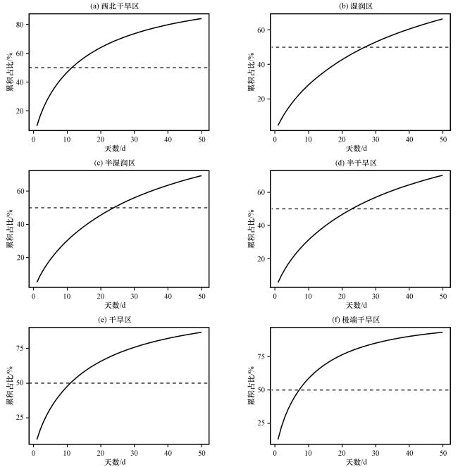
图8 1961 -2021年中国西北干旱区和5个子区域的日降水累积占比曲线(a)西北干旱区, (b)湿润区, (c)半湿润区, (d)半干旱区, (e)干旱区, (f)极端干旱区。横轴表示按日降水量由大到小排序的前N(N=1~50)天, 纵轴为对应日数累积降水量占年降水量的百分比(单位: %) Fig.8 Curves of the wettest days and their corresponding proportations for the accumulated daily precipitation in the arid region of Northwest China (NWC) and its five dry-wet sub-regions during 1961 -2021.(a) NWC, (b) humid, (c) semi-humid, (d) semi-arid, (e) arid, (f) hyper-arid.The x-axis represents the number of top-ranked precipitation days in a year, ordered by daily precipitation amount, and the y-axis indicates the percentage of cumulative precipitation in the corresponding wettest days to the annual precipitation (unit: %) |
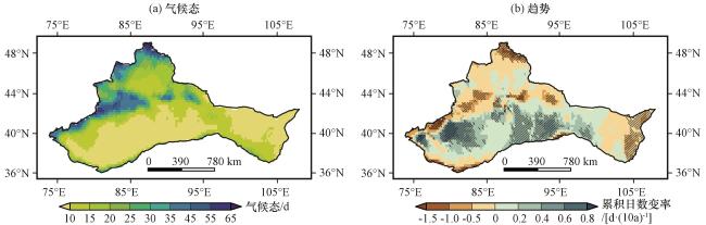
图9 1961 -2021年中国西北干旱区达到一半年降水量累积日数的气候态(a, 单位: d)和长期趋势[b, 单位: d·(10a)-1]的空间分布(b)中黑色斜线表示通过0.05显著性检验 Fig.9 Spatial distribution of the climatology (a, unit: d) and long-term trend [b, unit: d·(10a)-1] of the cumulative number of days contributing to half of the annual precipitation in the arid region of Northwest China (NWC) during 1961 -2021.In (b), black slanted lines indicate areas passing the 0.05 significance test |