
1 引言
2 数据与方法
2.1 研究区域
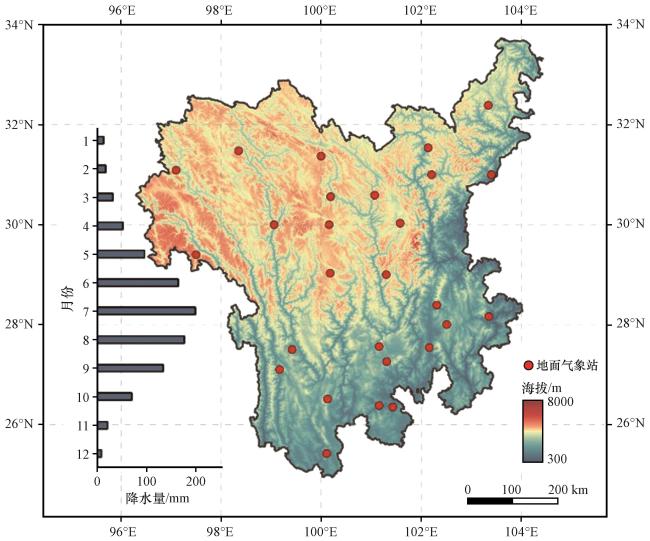
2.2 数据选取
2.3 统计量定义
表1 小时极端(强)降水的相关统计量Table 1 Associated statistics of hourly (very) extreme precipitation events |
| 统计量 | 定义 | 单位 |
|---|---|---|
| 小时极端(强)降水阈值 | 第95 (99)百分位的小时降水量 | mm·h-1 |
| 小时极端(强)降水量 | 超过第95 (99)百分位数部分的年均降水量 | mm |
| 小时极端(强)降水频次 | 超过第95 (99)百分位数部分的年均发生小时数 | h |
| 小时极端(强)降水强度 | 小时极端(强)降水量与次数的比值 | mm·h-1 |
| 小时极端(强)降水事件持续时间 | 单个小时极端(强)事件所经历的时长 | h |
3 结果
3.1 小时极端降水阈值
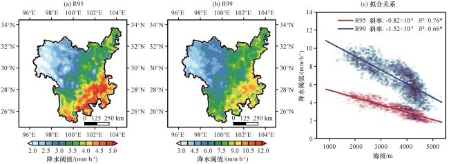
图2 横断山区小时极端降水(a)和小时极端强降水(b)阈值(单位: mm·h-1)及阈值与海拔的线性拟合关系(c)上标*表示通过99%置信水平检验 Fig.2 Thresholds (unit: mm·h-1) for hourly extreme precipitation (a) and hourly very extreme precipitation (b) in the Hengduan Mountain.Linear fit (c) of hourly extreme precipitation (red) and very extreme precipitation (blue) thresholds to elevation.The superscript * indicates that it passes the 99% confidence level test |
3.2 空间分布
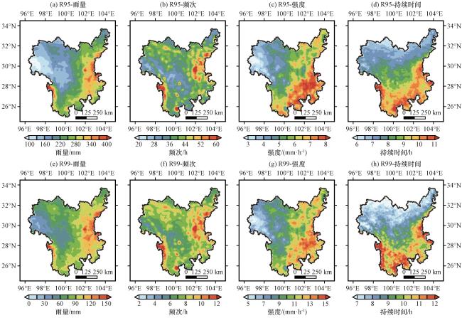
图3 横断山区小时极端降水(a~d)和极端强降水(e~h)雨量(a, e, 单位: mm)、 频次(b, f, 单位: h)、 强度(c, g, 单位: mm·h-1)和持续时间(d, h, 单位: h)空间分布图Fig.3 Spatial distribution of hourly extreme (a~d) and very extreme (e~h) precipitation amount (a, e, unit: mm), number (b, f, unit: h), intensity (c, g, unit: mm·h-1), and duration (d, h, unit: h) in the Hengduan Mountain |
表2 小时极端降水和小时极端强降水全年、 雨季和非雨季时期年均雨量与频次和强度的相关系数Table 2 Correlation coefficients between amount and number or intensity of hourly extreme precipitation and very extreme precipitation over the whole year, rainy and non-rainy season periods |
| 频次 | 强度 | ||||||
|---|---|---|---|---|---|---|---|
| 全年 | 雨季 | 非雨季 | 全年 | 雨季 | 非雨季 | ||
| 小时极端降水 | 0.70* | 0.64* | 0.95* | 0.77* | 0.81* | 0.39* | |
| 小时极端强降水 | 0.74* | 0.72* | 0.96* | 0.76* | 0.79* | 0.30* | |
上标*表示通过99%置信水平检验 (the superscript * indicates that it passes the 99% confidence level test) |
3.3 年际变化
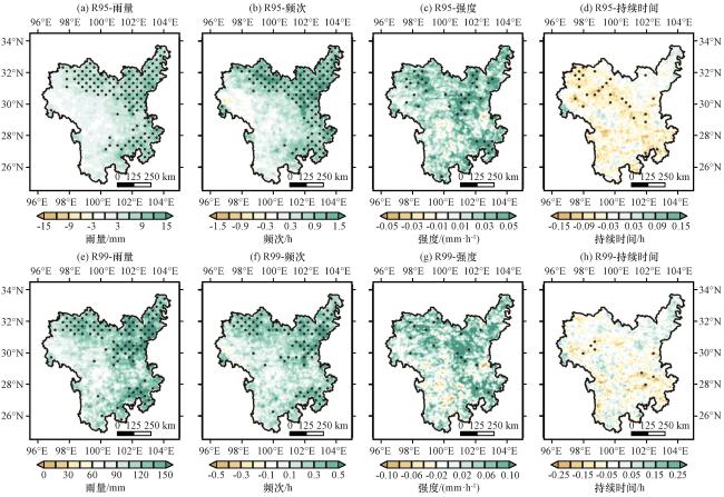
图4 横断山区小时极端降水(a~d)和极端强降水(e~f)雨量(a, e, 单位: mm)、 频次(b, f, 单位: h)、 强度(c, g, 单位: mm·h-1)和持续时间(d, h, 单位: h)年际变化趋势的空间分布打点区域为通过90%置信水平检验 Fig.4 Distribution of the interannual variations of hourly extreme (a~d) and very extreme (e~f) precipitation amount (a, e, unit: mm), number (b, f, unit: h), intensity (c, g, unit: mm·h-1), and duration (d, h, unit: h) in the Hengduan Mountain.Black dots indicate the stations that passed the 90% significance test |
表3 小时极端降水和小时极端强降水全年、 雨季和非雨季时期雨量年际变化趋势与频次和强度年际变化趋势之间相关系数Table 3 Correlation coefficients between interannual variations in amount and interannual variations in number or intensity of hourly extreme precipitation and very extreme precipitation over the whole year, rainy and non-rainy season periods |
| 频次 | 强度 | ||||||
|---|---|---|---|---|---|---|---|
| 全年 | 雨季 | 非雨季 | 全年 | 雨季 | 非雨季 | ||
| 小时极端降水 | 0.90* | 0.89* | 0.94* | 0.47* | 0.45* | 0.56* | |
| 小时极端强降水 | 0.91* | 0.90* | 0.94* | 0.44* | 0.45* | 0.60* | |
上标*表示通过99%置信水平检验(The superscript * indicates that it passes the 99% confidence level test) |
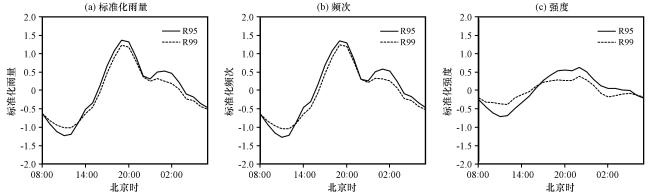
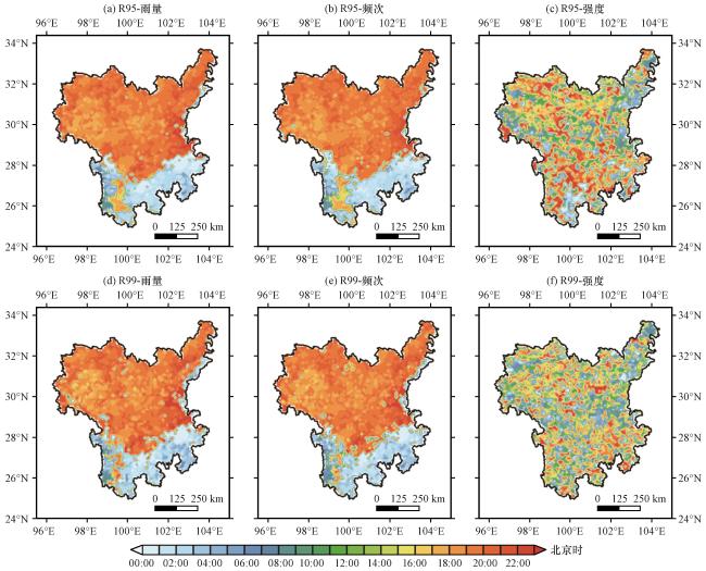
3.4 日变化
3.5 雨季与非雨季对小时极端降水的贡献
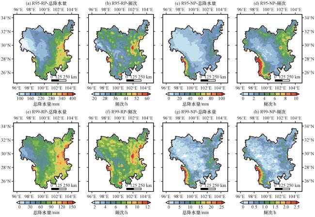
图7 横断山区雨季(a, b, e, f)和非雨季(c, d, g, h)小时极端降水(a~d)和极端强降水(e~h)雨量(单位: mm)和频次(单位: h)的空间分布Fig.7 Spatial distribution of hourly extreme (a~d) and very extreme (e~h) precipitation amount (unit: mm) and number (unit: h) during rainy season (a, b, e, f) and non-rainy season (c, d, g, h) in the Hengduan Mountain |
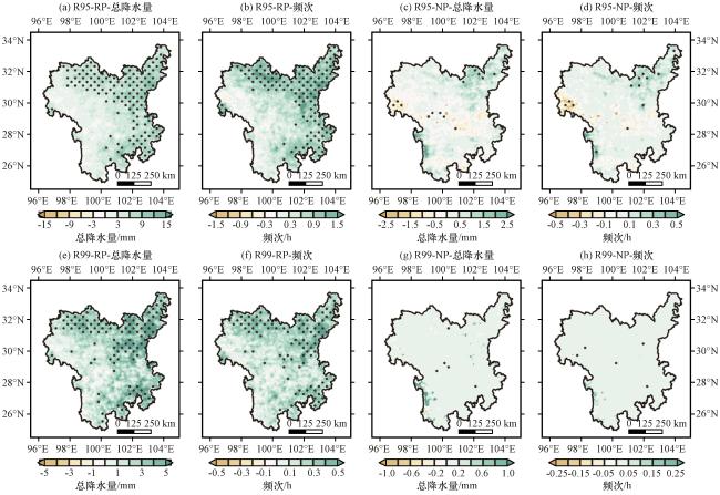
图8 横断山区雨季(a, b, e, f)和非雨季(c, d, g, h)小时极端降水(a~d)和极端强降水(e~h)雨量(单位: mm)和频次(单位: h)的年际变化趋势空间分布打点区域为通过90%置信水平检验 Fig.8 Distribution of the interannual variations of hourly extreme (a~d) and very extreme (e~h) precipitation amount (unit: mm) and number (unit: h) during rainy season (a, b, e, f) and non-rainy season (c, d, g, h) in the Hengduan Mountain.Black dots indicate the stations that passed the 90% significance test |
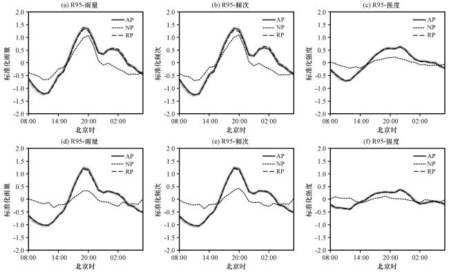
图9 横断山区全年(AP)、 雨季(RP)和非雨季(NP)时期小时极端降水(a~c)和小时极端强降水(d~f)雨量(a, d, 单位: mm)、频次(b, e, 单位: h)和强度(c, f, 单位: mm·h-1)的日变化特征Fig.9 Diurnal variations in normalized regional averaged rainfall amount (a, d, unit: mm), number (b, e, unit: h), intensity (c, f, unit: mm·h-1) of hourly extreme (a~c) and very extreme (d~f) precipitation during the annual (AP),rainy season (RP) and non-rainy season (NP) in the Hengduan Mountain |