Journals
  Publication Years
  Channels
 
  Article type
 

Not found West Pacific subtropical High during rainstorm formation

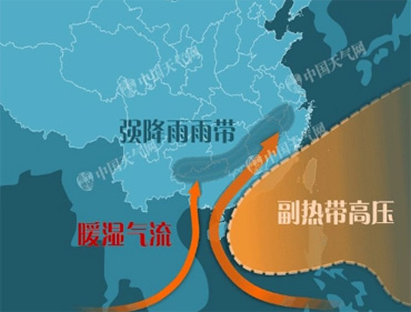
西太平洋副热带高压(在中国简称西太平洋副高),是一个在太平洋上空的永久性高压环流系统,范围一般采用500 hPa高度图上西太平洋地区,5880 gpm线包围的区域为代表。

西太平洋副高对我国天气的影响十分重要,夏半年更为突出,这种影响一方面在西太平洋副高本身;另方面还在西太平洋副高与其周围天气系统间的相互作用。

副高是向我国大陆输送水汽的重要系统。我国降水的水汽来源,虽然主要依靠西南气流从印度洋输送来,而太平洋副高的位置、强度和活动,不仅对西南气流的水汽输送有关,而且还影响着它南侧的东南季风从太平洋向大陆输送来的水汽。同时,西太平洋副高的北侧是沿副高北上的暖湿空气与中纬度南下的冷空气相交绥的地带,往往形成大范围的阴雨天气,是我国大陆地区的重要降水带。


Default Latest Most Read  
Please wait a minute...
For Selected: Toggle Thumbnails
  • Characteristic Analysis on Two Regional Rainstorms at Guanzhong in Early Summer
  • ZHANG Yabin;MA Xiaohua;RAN Lingkun;HOU Jianzhong
  • 2016, 35 (3): 708-725. DOI: 10.7522/j.issn.1000-0534.2015.00014
  • Abstract (298) PDF (15060KB)(594)
  • NCEP 1°×1° reanalysis data,conventional observation data and satelite data are used to analyse characteristics of circulation pattern,physical field and Temperature of Black Body(TBB)for two early summer rainstorms at Guanzhong from 2 to 3 June 2006(the‘0602')and on 25 May 2013(the‘0525’)with midsummer case comparison.Results show that:before early summer rainstorms happen,Tibetan High is weak and located obviously southward,which cause morphology and location changes of 200 hPa Jet north to rainstorm are small.At the same time,wind longitudinal gradient at the south side of 200 hPa Jet increases significantly.During early summer rainstorm there are no impacts of West Pacific Subtropical High and remote typhoon,meanwhile,westerlies influence systems at upstream and surrounding area are different,which lead to vapor transportation and convergence at low levels are significantly weaker than midsummer cases and different distributions.Stability of high pressure around China eastern continent on 850 hPa is contributed to duration of southeast vapor transportation to rainstorm area.Early summer rainstorms happened under potential stable stratification and warm and moist air climbe northward along the low level cold air.Isentropic surface tilted northward with height increasing along rainstorm centre and it exist energy front genesis and symmetric instability.Moist Potential Vorticity (MPV)anomaly appear over rainstorm area.Meanwhile,vertical difference between deeply positive MPV at mid-high levels and shallowly negative at low level increases.MPV above 300 hPa increase significantly.Zonal vertical circulations about 300 km east to early summer rainstorms contribute to upward movement maintaining.The maximum of vertical velocity,central height and unstable energy near high energy ridge at low level during early summer rainstorms are obviously lower than midsummer cases.Total helicity significantly increased zone is indicative to early summer rainstorm beginning.Zero line between positive and negative helicity area is near the north boundary of early summer heavy rain,meanwhile,positive helicity increasing center is near the north boundary of rainstorm.There is a significant negative helicity area north to Guanzhong.Positive helicity range and strength near Guanzhong are obvious small and its center moving and increase area are relatively south with midsummer case comparison.Meanwhile,locations of positive helicity centers in vertical direction are relatively dispersive.Early summer rainstorm clouds are large and have complex structure,which mainly composed of northern shield shaped cloud corresponding significant anticyclonic region at high level and southern belt cloud region at low level.TBB centers are higher than -60 ℃ and cloud top are lower than those of midsummer cases.Early summer rainstorm mainly located near the convergence area of north and south clouds and strong belt echo rather than TBB central or large gradient areas.
  • Baidu(4)
  • Some Influence Factors of a Sudden Rainstorm Event in Northeast Sichuan Basin of China
  • Fangli ZHANG;Guoping LI;Xiao LUO
  • 2020, 39 (2): 321-332. DOI: 10.7522/j.issn.1000-0534.2019.00080
  • Abstract (537) HTML (20) PDF (11446KB)(447)
  • Using the data of ERA5 reanalysis as well as a new generation of radar mosaic data, a sudden rainstorm in Northeast Sichuan Basin was fully analyzed, including its influencing systems and dynamic impact factors.The analysis indicates that the predominate influencing systems of this process are the middle-latitude trough in 500 hPa moving to east, the Western Pacific subtropical high which extends to west, the southwest low-level jet(SWLJ) in the lower troposphere and the shear line of low layer.The large-scale SWLJ and the meso-micro scale low-level jet in mountainous terrain built a dynamical coupling of the positive vorticity column and strong divergence column in low-level.The strong upward vertical movement, result from the convergence ascending of low-level jet exit region and the local topographic forcing, which is the trigger condition in the rainstorm.The potential instability stratification established by the low-level jet is the thermal condition of this rainstorm.The main reason for the increase of precipitation in the second stage is that cold air gradually intrudes into the upper layer from the lower layer.The topography in Northeast Sichuan Basin is the enhancement factor in the process of rainstorm.It influences the vertical ascending motion through the uplift effects.The windward slope of Qin-Ba mountainous is relatively strong on first stage and the eastern leeward slope of the Qinghai-Tibetan Plateau is relatively strong on the second stage.What’s more, the mountains terrain in Northeast Sichuan Basin make the mesoscale convection systems (MCSs) stagnant in Sichuan Basin and develop fully through the blocking effect.
  • Impact of Plateau and Cold Air on SHWP and Rain Belt Summer in 1998 and 1991
  • SONG Min-hong;QIAN Zheng-an
  • 2002, 21 (6): 556-564.
  • Abstract (255) PDF (500KB)(534)
  • The 500 hPa Subtropical High over the West Pacific(SHWP) is one of the members of summery monsoon systems in Eastern Asia,it has the important influence on the main rain belt in China summer.In this paper to seek the forecast precursors for medium-and short-range forecast of the SHWP moving southward and northward suddenly,the impacts on the SHWP moving southward and northward and associated rain belt of the Qinghai-Xizang Plateau(QXP) vortexes moving eastward,the 100 hPa Southern Asia High(SAH) moving southward and northward,as well as the cold air invading from the North have been analyzed,utilizing the daily weather maps from June to August in 1998 and 1991,and the observational data from the Second Meteorology Science Test on the QXP,and the daily averaged gridded reanalysis data(e.g. u,v,h) on 2.5°×2.5° from NCEP/NCAR.The main conclusions are as follows:1) If the air-column thickness between 300 and 500 layers over the eastern QXP is greater than or equal to 392 gpdm,then the QXP vortexes moves eastward out of the QXP,and the southwest vortexes occurs and moves eastward,as a result,the SHWP moves southward and the rainstorm belt occurs in mid-and lower reaches of Changjiang River in the future.2) Both the eastern section of SAH ridge line and the west section of the SHWP ridge line have the same trend of moving southward and northward.But the former is much more stable and changes three days ahead.We can predict the moving of SWHP and the associated rain belt.3) If there are the cold air invading in North China and more than 2 m·s-1 positive and negative south wind anomaly on 850 hPa occurring Changjiang River,the rainstorm belt occurs easily in the transition band of the positive and negative anomaly of the south wind,especially on the negative anomaly side.It makes the SWHP more stable.4) Certainly,the combined consideration will be needed in real forecast,and the first priority will be given to the SAH moving and the north cold air invading.
  • Baidu(72)
  • Diagnostic Analysis on Torrential Rain Caused by the Tropical Storm Billis(0604)
  • KANG Zhi-ming;CHEN Tao;QIAN Chuan-hai;YANG Ke-ming
  • 2008, 27 (3): 596-607.
  • Abstract (212) PDF (2400KB)(508)
  • Based on the intensive observations, precipitation data of automatic observations and NCEP(1°×1°) 6 h reanalysis data, the study on the torrential rain caused by the Tropical Storm Billis(0604) was made through the analyses on energy, thermodynamics, vapor flux, synoptic circulation, cold air and terrain effect. The results show that the combination of west Pacific subtropical high and mainland high, extremely strong southwestern monsoon, intensive divergent stream filed in upper level and weak vertical shear jointly contributed to the persistence of Bills over land, and the southwest monsoon was strengthened by cross equatorial flow and transported the moisture in the Bay of Bengal and South China Sea into the rainfall area. Also the study arrived at some conclusions as follows:(1) The apparent heat energy was the main component part of the energy of Billis, the latent heat energy was second only to the apparent one at the low level of troposphere, but the potential energy takes the place of latent heat energy above the middle level of the troposphere. The maintenance of the total energy of the storm mainly depended on the advection of latent heat energy, which also contributed to the persistence of warm structure and the advent of torrential rain. The kinetic energy that caused the blustering weather of the storm was generated by the Ageostrophic wind, which crossed the isobar and intensified the baroclinicity of the air.(2) The local variation term was reverse to the advection term for both the apparent heat source(Q1) and moisture sink(Q2). When warm and moist air at low level was lifted to higher level, the condensation of the moisture and the release of latent heat resultedin the anomaly of Q1 and Q2 through vertical transportation term. The feedback from the latent heat associated with cumulus convection playeda significant role in the torrential rain of typhoon.(3) The cold air invaded the lower level part of the storm from east and west sides, and triggered off the convection. The deformation term of the vorticity and divergence at atmospheric and surface level made the mountain area a vorticity source, where the mesoscale convective systems were constantly triggered off and the rainfall was increased.
  • Baidu(42)
  • Frontogenesis and Moisture Characteristic Analysis on a Sudden Rainstorm at the Edge of Subtropical High
  • QIU Guiqiang;ZHAO Guixiang;DONG Chunqing;WANG Xiaoli
  • 2018, 37 (4): 946-957. DOI: 10.7522/j.issn.1000-0534.2017.00059
  • Abstract (454) HTML PDF (14843KB)(261)
  • For the sudden rainstorm predicted with a large deviation by several operational models, which occurred at the edge of western Pacific subtropical high (WPSH) southwest of Shanxi province at night on 31 July 2010, the conventional observation, hourly precipitation, TBB data derived from FY-2E satellite and WRF model high resolution simulation results were used to analyze the evolution of rainstorm, frontogenesis and moisture characteristics. The results indicated that the sudden rainstorm was due to frontogenesis that caused by dry and cold air at the back of upper trough pushing the warm and moist air at the edge of WPSH. The meso-β circular convective system (MβCCS) led to the rainstorm directly. The formation and development of mesoscale-β vortex provided a favorable condition of moisture convergence to the maintenance of MβCCS. The surface cold front and nearby mesoscale convergence line triggered the convection develop. Frontogenesis diagnosis showed that the vertical structure of low-level convergence and middle-level divergence led to low-level horizontal frontogenesis and middle-level horizontal frontolysis in the troposphere. The strong ascending motion made the height of strong instability layer rise and thus led to strong middle-level vertical frontogenesis. The vertical and horizontal frontogenesis happened at the same time, but the vertical frontogenesis was an order of magnitude larger than the horizontal frontogenesis. The appearance of middle-and low-level strong frontogenesis and secondary circulation corresponded well with the time and the location of strong precipitation. In comparison, the tilting term contributed most to total frontogenesis, and the convergence term contributed least. The strength of middle-and low-level frontogenesis is beneficial to the rise of low-level moisture. In the process of frontogenesis, deep moisture saturation layer thickness and the water vapor content stretching to high-level have evident indication to the forecast of local strong precipitation. At last, the intensity and moving track of upper cold air and development of MβCCS are major points to determine the location of such type of rainstorm.
  • Variations of South Asia High and West Pacific SubtropicalHigh and their Relationships with Precipitation
  • CHEN Yong-ren-;LI Yue-qing;QI Dong-mei
  • 2011, 30 (5): 1148-1157.
  • Abstract (655) PDF (1361KB)(1091)
  • Using the precipitation data of 160 climatic stations in China and NCEP/NCAR reanalysis data, the characteristics on South Asia High (SAH) and the Wes Pacific Subtropical High (WPSH) and their effects on precipitation in mid-summer were analyzed. The results showed that the index of eastward extension of SAH had time scales of 3~6 a periods, 10~15 a and approximate 20 a period. The index of westward extension of WPSH had time scales of 3~6 a and approximate 20 a periods. Also the relations between the index of eastward extension of SAH and the index of westward extension of WPSH were more significant from 1980 to 1990. Meanwhile, the results of spectrum analysis showed that both relationships were very significant in 10~15 a, 3 a, 6 a periods, and there was significant correlative relation between the precipitation of Yangtze River and SAH on 10~15 a time scales, but not significant relation between Yangtze River and WPSH. To some extent, the precipitation variation of Yangtze River region had close relationship with SAH in 10~15 a periods, therefore, the index of eastward extension of SAH can be regard to forecast precipitation interdecadal variation of Yangtze River in mid-summer as a conference signal.
  • Baidu(13)
  • Analysis and Application of the Two Type Vorticity Vectors on a Heavy Rainfall in Sichuan Basin
  • SONG Wenwen;LI Guoping
  • 2016, 35 (6): 1464-1475. DOI: 10.7522/j.issn.1000-0534.2015.00115
  • Abstract (300) HTML PDF (4903KB)(1147)
  • By using the WRF model, NCEP 1°×1° reanalysis datasets and conventional observational data, numerical simulation and diagnostic analysis is performed for a heavy rainfall in Sichuan basin occurring during June 29th-July 2nd, 2013. The results showed the heavy rainfall was caused by the interaction of plateau vortex and southwest vortex, and the blocking effect formed by the west pacific subtropical high westward extension and stabilize in Sichuan Basin led to stagnate of plateau vortex and southwest vortex. WFR model can better simulate the affecting system, precipitation area and strength of the precipitation. θe analysis showed the heavy rainfall area was in the high temperature and high humidity area, and the lower level of the heavy rainfall area was convective instability area. Equivalent potential temperature was dense in the middle and upper level, and the isothermal surface of the equivalent potential temperature was steep. As the rainfall went on, the convective instability energy released, and the equivalent potential temperature declined. By using the convective vorticity vector (CVV) and moist vorticity vector (MVV), diagnostic analysis result of the heavy rainfall showed the vertical integration of the CVV and MVV vertical component and the trend of the positive cincture of the horizontal distribution was consistent with the precipitation area, and the maximum center could better correspond to the precipitation center. The distribution and development of the maximum area of the CVV and MVV vertical component was consistent with the movement and development of the precipitation area, the coincident positive distribution from low level to top level of the precipitation area was indicative to the heavy rainfall development. The CVV and MVV vertical component can well indicate the development and evolution of the heavy rainfall system in Sichuan Basin.
  • Research and Analysis of Dry Intrusion during Beijing ‘7·21' Extreme Torrential Rain
  • TANG Pengyu;HE Hongrang;YANG Xiangrong;YAN Yuxiang;WANG Yahua;MIAO Ziqing
  • 2015, 34 (1): 210-219. DOI: 10.7522/j.issn.1000-0534.2013.00128
  • Abstract (280) PDF (6107KB)(1191)
  • The weather situation and mesoscale systems characteristics of the extreme torrential rain occurred in Beijing on 21 July 2012 was analyzed. With the mesoscale numerical mode WRFV3.2 the extreme heavy precipitation is simulated. And based on the dry intrusion theory, the process of dry cold air activities during the heavy rain and its impact of the torrential rain are analyzed. The results show that: The torrential rain occurred in weather situation of the violent intersection of the southward cold air guided by upper trough and strong southwest warm wet air in North China area. WPSA prevented the upper-level trough from moving eastward and thus the precipitation process in Beijing kept a long time. The convective development process is along with the obvious mesoscale convective complex (MCC) activities, and MCC's ongoing activities and the rainfall centers are temporal and spatial consistent. The WRF model could accurately simulate this torrential rain process. Within 24 h before the precipitation occurs there is constant high potential vorticity and low humidity dry cold air from 35°N near the tropopause being transported along northward and downward path to 39°N near 700 hPa at the lower-level atmosphere in Beijing area. Dry intrusion changed little from 24 h to 10 h before the start of the precipitation, soon afterwards had a slight weakening and weakened rapidly after the precipitation started. The dry intrusion changed atmospheric thermal and dynamic environment of the Beijing area to impact the torrential rain before the precipitation started. Dry intrusion could increase the atmospheric potential instability in rainfall area and reserve CAPE abundant for the development of convection, providing the environment conducive for the occurrence and development of MCC. At the meantime, it increased the low-level cyclonic vorticity which is conducive to low-level air convergence and upward motion and this may be the trigger mechanism of severe convective weather, such as the MCC and its accompanying torrential rain in Beijing area.
  • Relation of Summer Rainstorm and West Pacific Ocean Subtropical High Circulation in Southeast Part of Guizhou Province
  • CHI Zai-xiang;BAI Hui;HUANG Hong;GONG Xue-qin;NIU Jun-mei
  • 2008, 27 (1): 176-183.
  • Abstract (184) PDF (723KB)(462)
  • hrough the generalized analysis of main impact systems, the various element field and the terrain characteristics of the local rainstorm in southeast Guizhou in summer of 1996-2005, the result show that, first, 9 time local rainstorm are closely related with the position change of west Pacific subtropical high(WPSTH), and the southwest air flow of the SPSTH circulation turn into jet stream, which transports the massive water vapor and the instability energy. And then the strengthened function of special advantageous terrain creates the local rainstorm. According to the rainstorm area, we have divided it into four kinds of types, namely west rainstorm, eastern rainstorm, south rainstorm and middle rainstorm, but the southern rainstorm and the middle rainstorm have the mid-and low-level low vortex shear line coordination.
  • Baidu(22)
  • Analysis on the Causes of an Extreme Rainstorm in the Eastern Xinjiang
  • Xiaocui ZHUANG;Boyuan LI;Rong QING;Ruqi LI;Yunhui ZHANG;Songzhu BAI
  • 2020, 39 (5): 947-959. DOI: 10.7522/j.issn.1000-0534.2019.00081
  • Abstract (589) HTML (12) PDF (11743KB)(810)
  • By using FNL reanalysis data, the routine observation data, the regional automatic station data, FY-2G data, Analysis of extreme rainstorm environmental field characteristics in eastern Xinjiang on July 31, 2018, and compared with the research results of torrential rain in Xinjiang and southern China.The results are as follows: The extreme rainstorm were in the stable two ridges one trough large-scale circulation background; It caused by elevated convection; The rainstorm zone were located in the right side of southwest jet stream inlet region in high altitude, the Confluence area on the 500 hPa from southwest stream before central Asia low vortex and south airflow From western Pacific subtropical high on the west side, front convergence zone of southeast low level jet stream outlet zone on the 700 hPa and the overlapping area of the negative variable temperature area behind the cold front on the ground map; Central Asia low vortex of 500 hPa, low level jet of 700 hPa and its anterior convergence area, strong frontal zone 800~600 hPa that the elevated convection were triggered; Strong convergence and high level strong divergence nearby the lower troposphere 700 hPa, it provides dynamic triggering conditions for the development of elevated convection, so that SW Warm and Wet Air Flow in the Front of Central Asian Low Vortex and water vapor bypasses and crosses the Qinghai-Xizang Plateau, from the Arabian sea, Bay of Bengal, South China Sea and Western Pacific and Convergence and concentration rapidly in rainstorm area, and constantly being lifted to the sky, it provides sufficient water vapor condition for extreme rainstorm.The extreme rainstorm in this region is quite different from that in other parts of Xinjiang; There were also significant differences between the elevated convection system in south China.